
Images


September 29, 2020 - Burn Scars in Oregon
 Tweet
Tweet
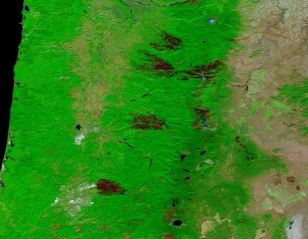
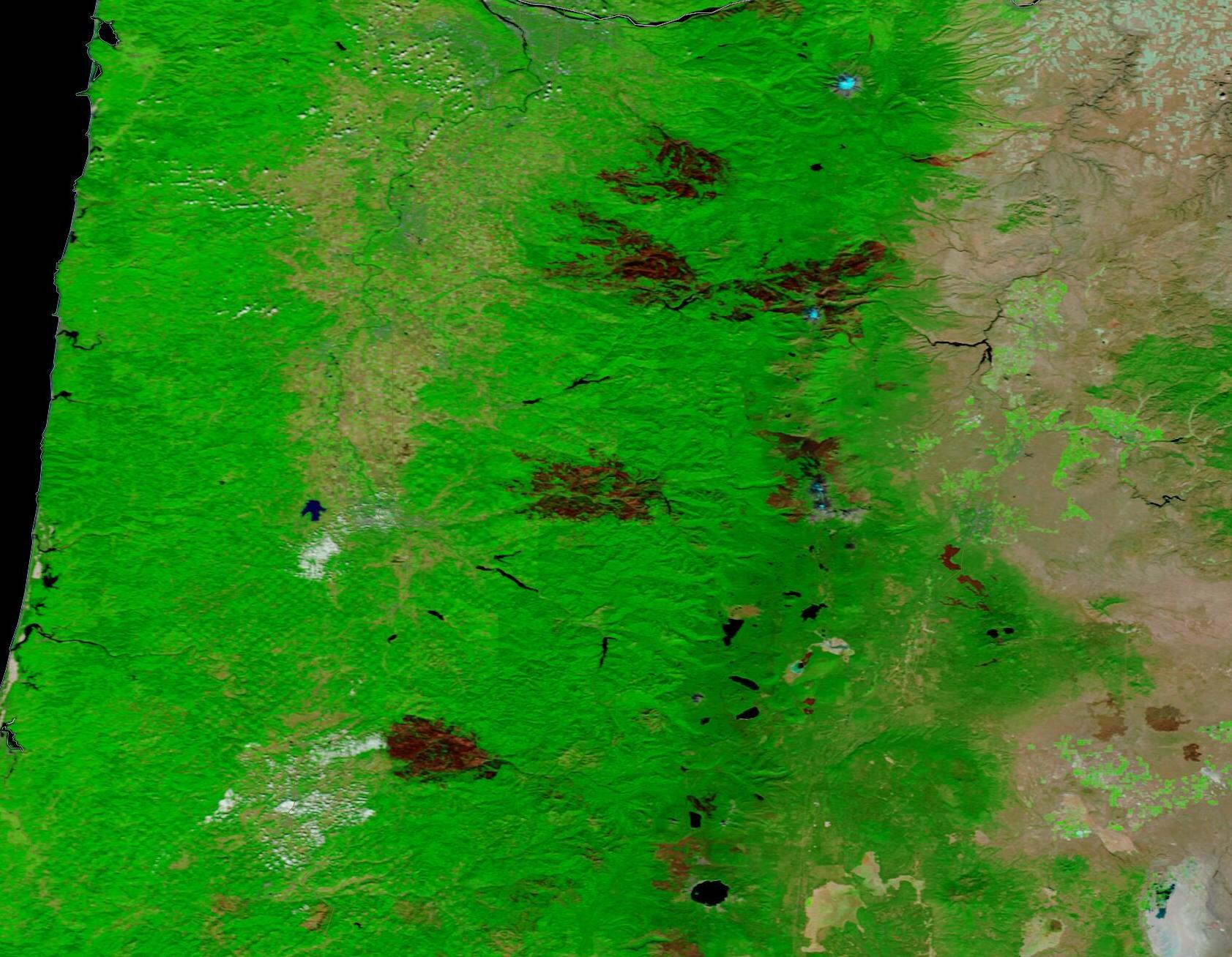
An intense fire season has left Oregon heavily scarred. On September 27, 2020, the Moderate Resolution Imaging Spectroradiometer (MODIS) on board NASA’s Terra satellite acquired a false-color image that highlights massive burn scars across the state.
By using visible and near-infrared light (bands 7,2,1) the burn scars – which may appear black, brown, or brick red - stand out in stark contrast to vegetation, which appears bright green. Open land appears tan, deep water is colored deep blue and clouds, when present, may appear either white or tinted with electric blue. The color variation in burn scars depends on type of vegetation burned, the completeness of the burn, the amount of residue remaining after the burn, and the age of the burn.
At least six large new burn scars are visible in this image. The largest scar measures 50 miles (80.4 km) long and more than 22 miles (35.4 km) wide at the widest point. Several other smaller scars also sit in the green vegetation. Also seen are numerous deep blue areas marking lakes and rivers. These are similar enough to small burn scars that it could be possible to confuse the two.
While this single image gives significant information on the landcover change from fire, observing two similar images acquired by MODIS on the same satellite at two different days, one before the fires and one after, is even more informative. Comparisons can dramatically reveal the differences caused by fire and also the stability of structures such as lakes and rivers.
Thanks to the NASA Worldview App, a beautiful roll-over comparison of MODIS false-color images of Oregon acquired on July 19, 2020 (before most of the fires started) and this one, acquired September 27 can be found here.
To use the roll-over bar, you may have to tap the up-arrow on the right-hand side of the Worldview title box. You can then drag the bar to the right to see the landcover change.
NASA's Earth Observing System Data and Information System (EOSDIS) Worldview application provides the capability to interactively browse over 700 global, full-resolution satellite imagery layers and then download the underlying data. Many of the available imagery layers are updated within three hours of observation, essentially showing the entire Earth as it looks "right now".
Image Facts
Satellite:
Terra
Date Acquired: 9/27/2020
Resolutions:
1km (14.2 KB), 500m (327.6 KB), 250m (321.5 KB)
Bands Used: 7,2,1
Image Credit:
MODIS Land Rapid Response Team, NASA GSFC
An intense fire season has left Oregon heavily scarred. On September 27, 2020, the Moderate Resolution Imaging Spectroradiometer (MODIS) on board NASA’s Terra satellite acquired a false-color image that highlights massive burn scars across the state.
By using visible and near-infrared light (bands 7,2,1) the burn scars – which may appear black, brown, or brick red - stand out in stark contrast to vegetation, which appears bright green. Open land appears tan, deep water is colored deep blue and clouds, when present, may appear either white or tinted with electric blue. The color variation in burn scars depends on type of vegetation burned, the completeness of the burn, the amount of residue remaining after the burn, and the age of the burn.
At least six large new burn scars are visible in this image. The largest scar measures 50 miles (80.4 km) long and more than 22 miles (35.4 km) wide at the widest point. Several other smaller scars also sit in the green vegetation. Also seen are numerous deep blue areas marking lakes and rivers. These are similar enough to small burn scars that it could be possible to confuse the two.
While this single image gives significant information on the landcover change from fire, observing two similar images acquired by MODIS on the same satellite at two different days, one before the fires and one after, is even more informative. Comparisons can dramatically reveal the differences caused by fire and also the stability of structures such as lakes and rivers.
Thanks to the NASA Worldview App, a beautiful roll-over comparison of MODIS false-color images of Oregon acquired on July 19, 2020 (before most of the fires started) and this one, acquired September 27 can be found here. To use the roll-over bar, you may have to tap the up-arrow on the right-hand side of the Worldview title box. You can then drag the bar to the right to see the landcover change.
NASA's Earth Observing System Data and Information System (EOSDIS) Worldview application provides the capability to interactively browse over 700 global, full-resolution satellite imagery layers and then download the underlying data. Many of the available imagery layers are updated within three hours of observation, essentially showing the entire Earth as it looks "right now".
Image Facts
Satellite:
Terra
Date Acquired: 9/27/2020
Resolutions:
1km (14.2 KB), 500m (327.6 KB), 250m (321.5 KB)
Bands Used: 7,2,1
Image Credit:
MODIS Land Rapid Response Team, NASA GSFC
