
Images


November 28, 2020 - Tropical Cyclon Nivar
 Tweet
Tweet
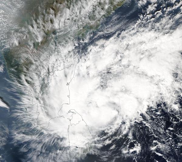
Tropical Cyclone Nivar formed over the southern Bay of Bengal on November 23, 2020 and moved northwest towards the southeastern Indian coastline. By 0000 UTC on November 24 the cyclone’s center was located about 250 km (155 mi) northeast of Trincomalee City, Sri Lanka. Maximum sustained winds were 74 km/h (46 mph).
The Moderate Resolution Imaging Spectroradiometer (MODIS) on board NASA’s Aqua satellite acquired a true-color image of Tropical Cyclone Nivar on November 24 as it moved northwest off the coast of Sri Lanka. Convective bands circulated around a large and loosely formed eye, and the clouds associated with the storm stretched more than 1,000 miles (1,610 km) at its widest point. Heavy rain and storm surge were impacting Sri Lanka at the time the image was captured.
The storm made landfall on the southeastern coast of India near Marakkanam in Tamil Nadu State between 1800 and 2100 UTC on November 25. According to the India Meteorological Department (IMD), Tropical Cyclone carried maximum sustained winds of 120-130 km/h (75-80 mph) and gusts reaching 145 km/h (90 mph). By November 26 Nivar had weakened substantially while moving inland. Initial reports counted five people killed by the storm, hundreds of homes damaged, and about 175,000 people evacuated in Tamil Nadu.
Image Facts
Satellite:
Aqua
Date Acquired: 11/24/2020
Resolutions:
1km (436.5 KB), 500m (1.4 MB), 250m (4.2 MB)
Bands Used: 1,4,3
Image Credit:
MODIS Land Rapid Response Team, NASA GSFC
