
Images


January 10, 2021 - The Caribbean
 Tweet
Tweet
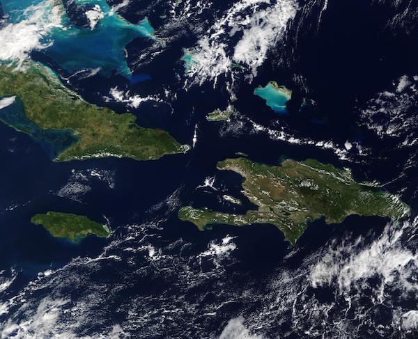
“The chief character in this narrative is the Caribbean Sea, one of the world's most alluring bodies of water, a rare gem among the oceans, defined by the islands that form a chain of lovely jewels to the north and east”.
So starts James Michener’s insightful book, “Caribbean”, which describes the allure and roughly 700 years of history of the glittering string of islands that rise from the blue waters of the Caribbean Sea. Michener’s skills captured much of the essence and historical highlights of the Caribbean, but the diversity and many-thousand-year history of the more than 700 islands, islets, and cays strewn across about 1.063 million square miles of blue water are impossible to completely capture, even in a 672-page tome.
On January 5, 2021, the Moderate Resolution Imaging Spectroradiometer (MODIS) on board NASA’s Terra satellite acquired a true-color image of a slice of the Caribbean. This image captures the large islands of Hispaniola (east), Cuba (west) and Jamaica (south), all part of the Greater Antilles. Puerto Rico is also part of the Greater Antilles but is located east of Hispaniola and not in this image.
The Lucayan Archipelago sits north of the Greater Antilles and is often considered to be part of the Caribbean, despite not bordering the Caribbean Sea. The bright blue to the north of Hispaniola marks the coral reef and shallow water of the Turks and Caicos Islands. The colorful waters and green islands to the northwest are The Bahamas.
Image Facts
Satellite:
Terra
Date Acquired: 1/5/2020
Resolutions:
1km (270.5 KB), 500m (862.3 KB), 250m (2.3 MB)
Bands Used: 1,4,3
Image Credit:
MODIS Land Rapid Response Team, NASA GSFC
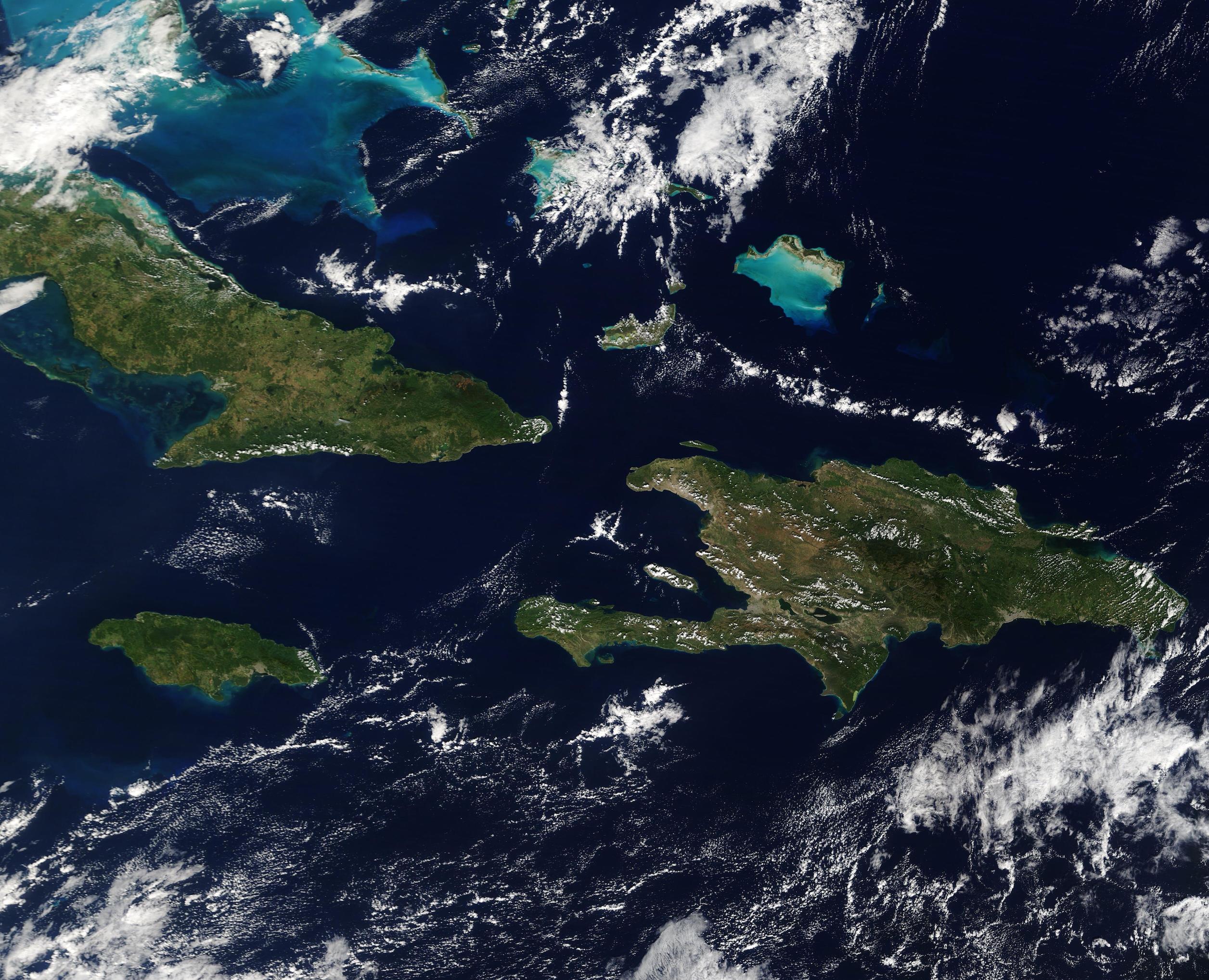
“The chief character in this narrative is the Caribbean Sea, one of the world's most alluring bodies of water, a rare gem among the oceans, defined by the islands that form a chain of lovely jewels to the north and east”. So starts James Michener’s insightful book, “Caribbean”, which describes the allure and roughly 700 years of history of the glittering string of islands that rise from the blue waters of the Caribbean Sea. Michener’s skills captured much of the essence and historical highlights of the Caribbean, but the diversity and many-thousand-year history of the more than 700 islands, islets, and cays strewn across about 1.063 million square miles of blue water are impossible to completely capture, even in a 672-page tome.
On January 5, 2021, the Moderate Resolution Imaging Spectroradiometer (MODIS) on board NASA’s Terra satellite acquired a true-color image of a slice of the Caribbean. This image captures the large islands of Hispaniola (east), Cuba (west) and Jamaica (south), all part of the Greater Antilles. Puerto Rico is also part of the Greater Antilles but is located east of Hispaniola and not in this image.
The Lucayan Archipelago sits north of the Greater Antilles and is often considered to be part of the Caribbean, despite not bordering the Caribbean Sea. The bright blue to the north of Hispaniola marks the coral reef and shallow water of the Turks and Caicos Islands. The colorful waters and green islands to the northwest are The Bahamas.
Image Facts
Satellite:
Terra
Date Acquired: 1/5/2020
Resolutions:
1km (270.5 KB), 500m (862.3 KB), 250m (2.3 MB)
Bands Used: 1,4,3
Image Credit:
MODIS Land Rapid Response Team, NASA GSFC
