
Images


February 20, 2021 - Tropical Cyclone Guambe
 Tweet
Tweet
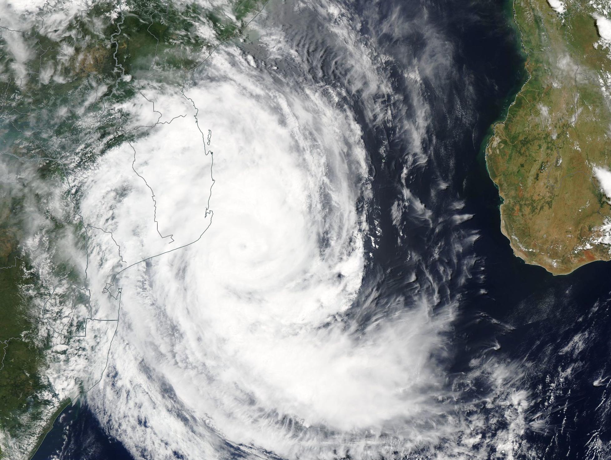
The third cyclone to impact Mozambique this season was spinning in the Mozambique Channel on February 19, 2021. Although the center of Tropical Cyclone Guambe is expected to remain 60-90 miles (100-150 km) off the coast, the western side of the storm will bring heavy rain and strong winds to parts of Sofala, Inhambane, Manica, and Zambezia Provinces over the next few days.
The Moderate Resolution Imaging Spectroradiometer (MODIS) on NASA’s Aqua satellite acquired a true-color image of Tropical Cyclone Guambe in the early afternoon of February 19. Around the time this image was captured, the storm carried maximum sustained winds of about 100 miles per hour (155 km/h)—equivalent to a Category 2 storm on the Saffir-Simpson Hurricane Wind Scale.
According to the Joint Typhoon Warning Center (JWTC), Tropical Cyclone Guambe is forecast to strengthen to a peak of about 103.5 mph (167 km/h) over the next 24 hours as it moves to the south-southeast, moving away from land.
Mozambique is in the middle of the annual cyclonic rainy season, which begins in October and ends in April. During this season, storms frequently come in from the Indian Ocean while flooding arises from southern African Basins. Two significant and damaging storms have preceded Tropical Cyclone Guambe. In January, Tropical Cyclone Eloise made landfall near Beira in Sofala Province in January, bringing damaging wind and severe flooding and Tropical Storm Chalane struck the region late in 2020.
Image Facts
Satellite:
Aqua
Date Acquired: 2/19/2021
Resolutions:
1km (411.3 KB), 500m (1.3 MB), 250m (3.8 MB)
Bands Used: 1,4,3
Image Credit:
MODIS Land Rapid Response Team, NASA GSFC
The third cyclone to impact Mozambique this season was spinning in the Mozambique Channel on February 19, 2021. Although the center of Tropical Cyclone Guambe is expected to remain 60-90 miles (100-150 km) off the coast, the western side of the storm will bring heavy rain and strong winds to parts of Sofala, Inhambane, Manica, and Zambezia Provinces over the next few days. The Moderate Resolution Imaging Spectroradiometer (MODIS) on NASA’s Aqua satellite acquired a true-color image of Tropical Cyclone Guambe in the early afternoon of February 19. Around the time this image was captured, the storm carried maximum sustained winds of about 100 miles per hour (155 km/h)—equivalent to a Category 2 storm on the Saffir-Simpson Hurricane Wind Scale.
According to the Joint Typhoon Warning Center (JWTC), Tropical Cyclone Guambe is forecast to strengthen to a peak of about 103.5 mph (167 km/h) over the next 24 hours as it moves to the south-southeast, moving away from land.
Mozambique is in the middle of the annual cyclonic rainy season, which begins in October and ends in April. During this season, storms frequently come in from the Indian Ocean while flooding arises from southern African Basins. Two significant and damaging storms have preceded Tropical Cyclone Guambe. In January, Tropical Cyclone Eloise made landfall near Beira in Sofala Province in January, bringing damaging wind and severe flooding and Tropical Storm Chalane struck the region late in 2020.
Image Facts
Satellite:
Aqua
Date Acquired: 2/19/2021
Resolutions:
1km (411.3 KB), 500m (1.3 MB), 250m (3.8 MB)
Bands Used: 1,4,3
Image Credit:
MODIS Land Rapid Response Team, NASA GSFC
