
Images


May 6, 2021 - Autumn along the Paraná River
 Tweet
Tweet
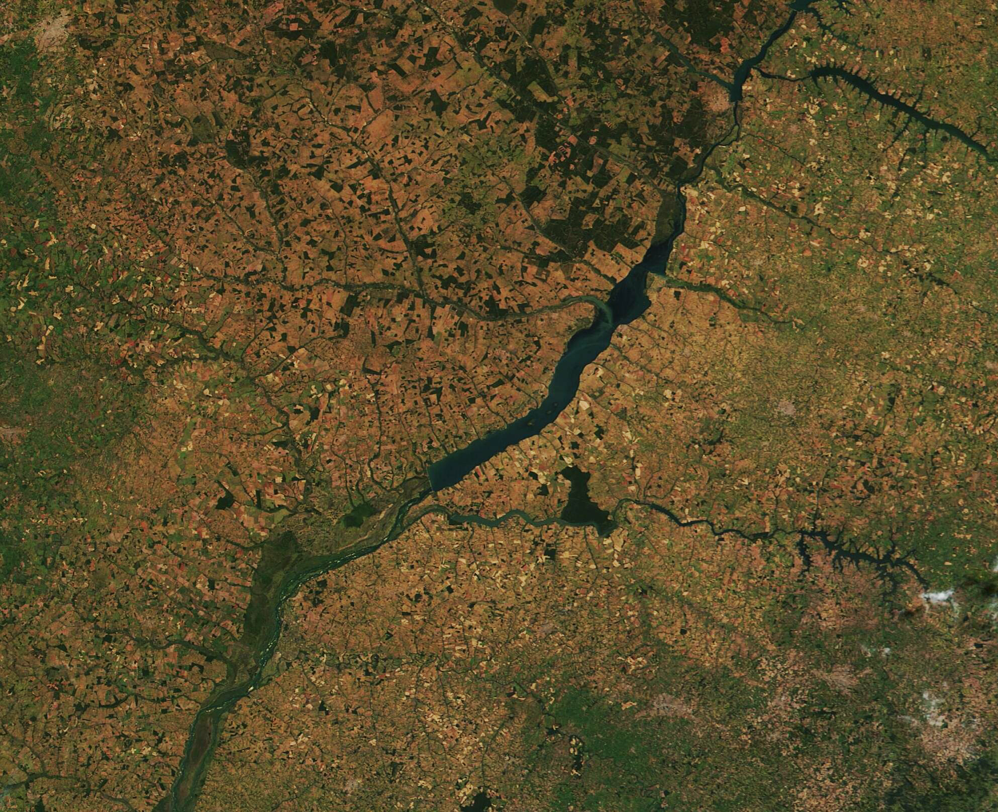
As summer softly turns to autumn in southwestern Brazil, a dramatic color change sweeps over the landscape.
On May 4, 2021, the Moderate Resolution Imaging Spectroradiometer (MODIS) on board NASA’s Terra satellite acquired a true-color image of a sunny autumn day over the Paraná River. South America’s second-longest river, the Paraná flows through Brazil, Paraguay, and Argentina for roughly 3,030 miles (4,880 km), serving many vital functions, such as providing a transportation link through the region, supporting a rich fishery, and a offering source of water for agriculture. This image captures a small section of the Paraná River as it flows between the states of Mato Grosso (west) and Sao Paulo (east).
The rich oranges and tans which offset patches of varying shades of green do not come from autumn leaves, as commonly occurs in some parts of the world, but are the colors of cropland and fields as weather cools and dry weather comes. Although residents and tourists often speak of Brazil as having four seasons, it really has two major seasons: the wet season and the dry season. The start of the dry season also comes in April, so autumn not only brings cooler temperatures but dries the fields, enhancing the color change as rains cease and vegetation begins to dry. The deep greens represent remnant patches of rainforest. Unlike deciduous forests, trees and plants of the rainforest remain green year-round, shedding their leaves asynchronously throughout the year rather than all at once as seasons change.
This image captured a single snapshot in time, on May 4, when the seasonal color change was well underway. To truly appreciate the transition between summer and autumn (and between the wet season and the dry season), it’s helpful to compare images acquired by the same instrument on different days. Thanks to the NASA Worldview app, this comparison is simple – just click
here to view a comparison between today's image and one acquired on December 20, 2020 (summer).
The NASA Worldview app provides a satellite's perspective of the planet as it looks today and as it has in the past through daily satellite images. Worldview is part of NASA’s Earth Observing System Data and Information System. EOSDIS makes the agency's large repository of data accessible and freely available to the public.
Image Facts
Satellite:
Terra
Date Acquired: 5/4/2021
Resolutions:
1km (358.2 KB), 500m (1002.3 KB), 250m (2.3 MB)
Bands Used: 1,4,3
Image Credit:
MODIS Land Rapid Response Team, NASA GSFC
As summer softly turns to autumn in southwestern Brazil, a dramatic color change sweeps over the landscape.
On May 4, 2021, the Moderate Resolution Imaging Spectroradiometer (MODIS) on board NASA’s Terra satellite acquired a true-color image of a sunny autumn day over the Paraná River. South America’s second-longest river, the Paraná flows through Brazil, Paraguay, and Argentina for roughly 3,030 miles (4,880 km), serving many vital functions, such as providing a transportation link through the region, supporting a rich fishery, and a offering source of water for agriculture. This image captures a small section of the Paraná River as it flows between the states of Mato Grosso (west) and Sao Paulo (east).
The rich oranges and tans which offset patches of varying shades of green do not come from autumn leaves, as commonly occurs in some parts of the world, but are the colors of cropland and fields as weather cools and dry weather comes. Although residents and tourists often speak of Brazil as having four seasons, it really has two major seasons: the wet season and the dry season. The start of the dry season also comes in April, so autumn not only brings cooler temperatures but dries the fields, enhancing the color change as rains cease and vegetation begins to dry. The deep greens represent remnant patches of rainforest. Unlike deciduous forests, trees and plants of the rainforest remain green year-round, shedding their leaves asynchronously throughout the year rather than all at once as seasons change.
This image captured a single snapshot in time, on May 4, when the seasonal color change was well underway. To truly appreciate the transition between summer and autumn (and between the wet season and the dry season), it’s helpful to compare images acquired by the same instrument on different days. Thanks to the NASA Worldview app, this comparison is simple – just click here to view a comparison between today's image and one acquired on December 20, 2020 (summer).
The NASA Worldview app provides a satellite's perspective of the planet as it looks today and as it has in the past through daily satellite images. Worldview is part of NASA’s Earth Observing System Data and Information System. EOSDIS makes the agency's large repository of data accessible and freely available to the public.
Image Facts
Satellite:
Terra
Date Acquired: 5/4/2021
Resolutions:
1km (358.2 KB), 500m (1002.3 KB), 250m (2.3 MB)
Bands Used: 1,4,3
Image Credit:
MODIS Land Rapid Response Team, NASA GSFC
