
Images


June 22, 2021 - Ice Break-up in the Greenland Sea
 Tweet
Tweet
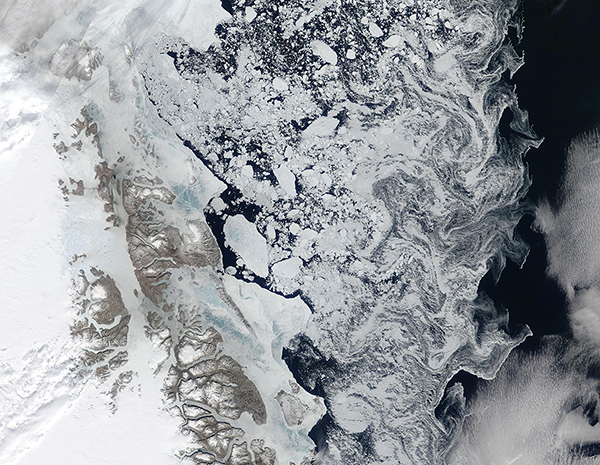
Ice break-up was well underway in the Greenland Sea in mid-June 2021. The Moderate Resolution imaging Spectroradiometer (MODIS) on board NASA’s Terra satellite acquired this true-color image on June 20.
Fast ice—ice that is connected to land and not adrift—clings to the coastline of and inlets of northeastern Greenland while sea ice of nearly every shape and size float offshore. The finest bits of ice are carried by winds and currents into delicate-appearing filigrees at the edge of open water. At the same time, snow and ice continue to cover interior Greenland and several bright-white glaciers are also visible.
According to the Arctic Regional Climate Centre Network, surface air temperature along the Greenland Sea is expected to be warmer than normal in June-August 2021. Sea ice break-up, which is defined as the first day in a 10-day interval where ice concentration falls below 50 percent in a region, is earlier along the northern Greenland coast than the average from 2012-2020. The minimum sea ice extent occurs during the month of September in the Northern Hemisphere. It is expected to be near normal for the Greenland Sea in 2021.
Image Facts
Satellite:
Terra
Date Acquired: 6/20/2021
Resolutions:
1km (374.6 KB), 500m (1.1 MB), 250m (1010 KB)
Bands Used: 1,4,3
Image Credit:
MODIS Land Rapid Response Team, NASA GSFC
