
Images


July 8, 2021 - Tropical Storm Elsa off the Florida Coast
 Tweet
Tweet
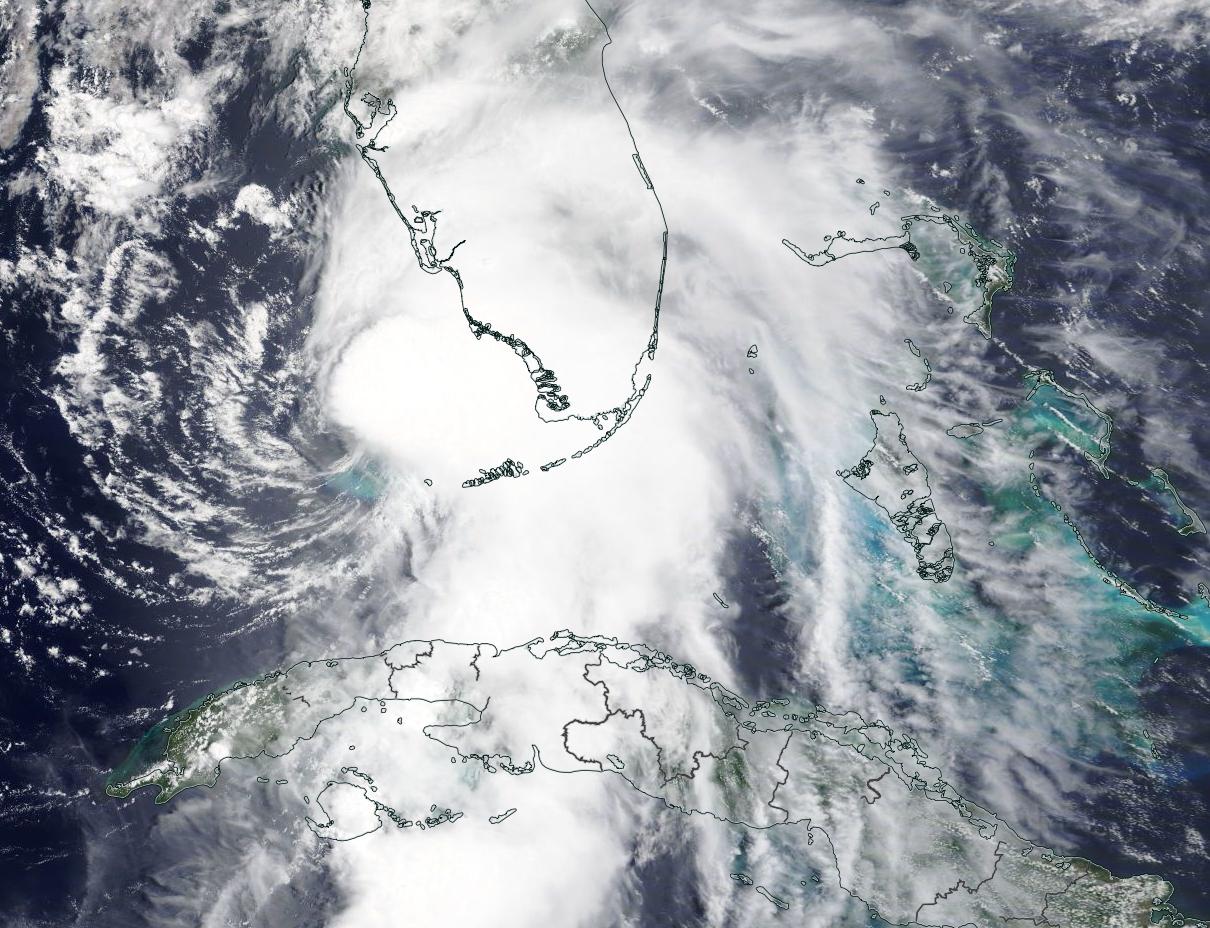
After a fast and furious run through the Caribbean, Tropical Storm Elsa was strengthening and taking aim at the coast of Florida on July 6, 2021, when the Moderate Resolution Imaging Spectroradiometer (MODIS) on board NASA’s Terra satellite acquired this true-color image of the storm.
At the time the image was acquired, Elsa sported a cloud-filled eye and rain bands covered the southern portion of the U.S. state of Florida. The rain bands and clouds stretched more than 208 miles (335 km) from the center of the storm to north of Orlando. At 2:00 p.m. EDT (1800 UTC) on July 6, the National Hurricane Center (NHC) advised that Tropical Storm Elsa was located at about 95 miles (150 km) northwest of Key West and about 180 miles (295 km) south of Tampa. It was carrying maximum sustained winds of 70 mph (100 km/h) and was moving north at 9 mph (15 km/h).
Several hours later, at 8:00 p.m. EDT on July 6 (0000 UTC July 7), maximum sustained winds had reached 75 mph (120 km/h), bringing Hurricane Elsa to Category 1 status on the Saffir-Simpson Hurricane Wind Scale. This strengthening was only temporary, however. At 2:00 a.m. EDT (0600 UTC) on July 7, Elsa was once again a tropical storm, with winds of 70 mph (115 km/h).
Tropical Storm Elsa continued to weaken before making landfall in Taylor County along the North Florida Gulf Coast at 11:00 a.m. EDT (1500 UTC) on July 7. At that time, maximum sustained winds were about 65 mph (100 km/h). Tropical storm force winds extended about 90 miles (145 km) from the center. After making landfall, Tropical Storm Elsa travelled across northern Florida and Georgia and is predicted to continue northward along the eastern coast of the United States before exiting over the Atlantic Ocean by July 9.
At 11:00 p.m. EDT on July 7 (0300 UTC July 8) Elsa had weakened, with maximum sustained winds of 45 mph (75 km/h). It was located about 80 mi (125 km) northwest of Brunswick, Georgia and about 150 mi (240 km) west-southwest of Charleston, South Carolina. Tropical Storm Warnings had been issued from the Little River Inlet of South Carolina to Great Egg Inlet, New Jersey, with Tropical Storm Watches extending northward to Massachusetts. The NHC also advised that interests in the Canadian Maritimes should monitor the storm.
Although impacts to property have been minimal in Florida, one person was reported killed in that state when a tree fell from the wind. In Georgia, ten people were injured in a Recreational Vehicle (RV) park when strong winds moved through, flipping camping vehicles.
Prior to impacting the United States, Elsa passed through the Windward Islands, south-western Dominican Republic, and south-eastern Haiti from July 2-5, causing considerable damage. Two people are reported dead in the Dominican Republic and one in St. Lucia. Reports state that about 600 homes were damaged in Barbados while several towns in St. Vincent and the Grenadines were isolated by the storm.
Cuba took a direct hit as Tropical Storm Elsa made landfall at 2:00 p.m. EDT (1800 UTC) on July 5 about 85 mi (140 km) southeast of Havana. Despite heavy rain and winds of 60 mph (95 km/h), Cuba seems to have been spared heavy damage.
Image Facts
Satellite:
Terra
Date Acquired: 7/6/2021
Resolutions:
1km (199.8 KB), 500m (639.6 KB), 250m (1.9 MB)
Bands Used: 1,4,3
Image Credit:
MODIS Land Rapid Response Team, NASA GSFC
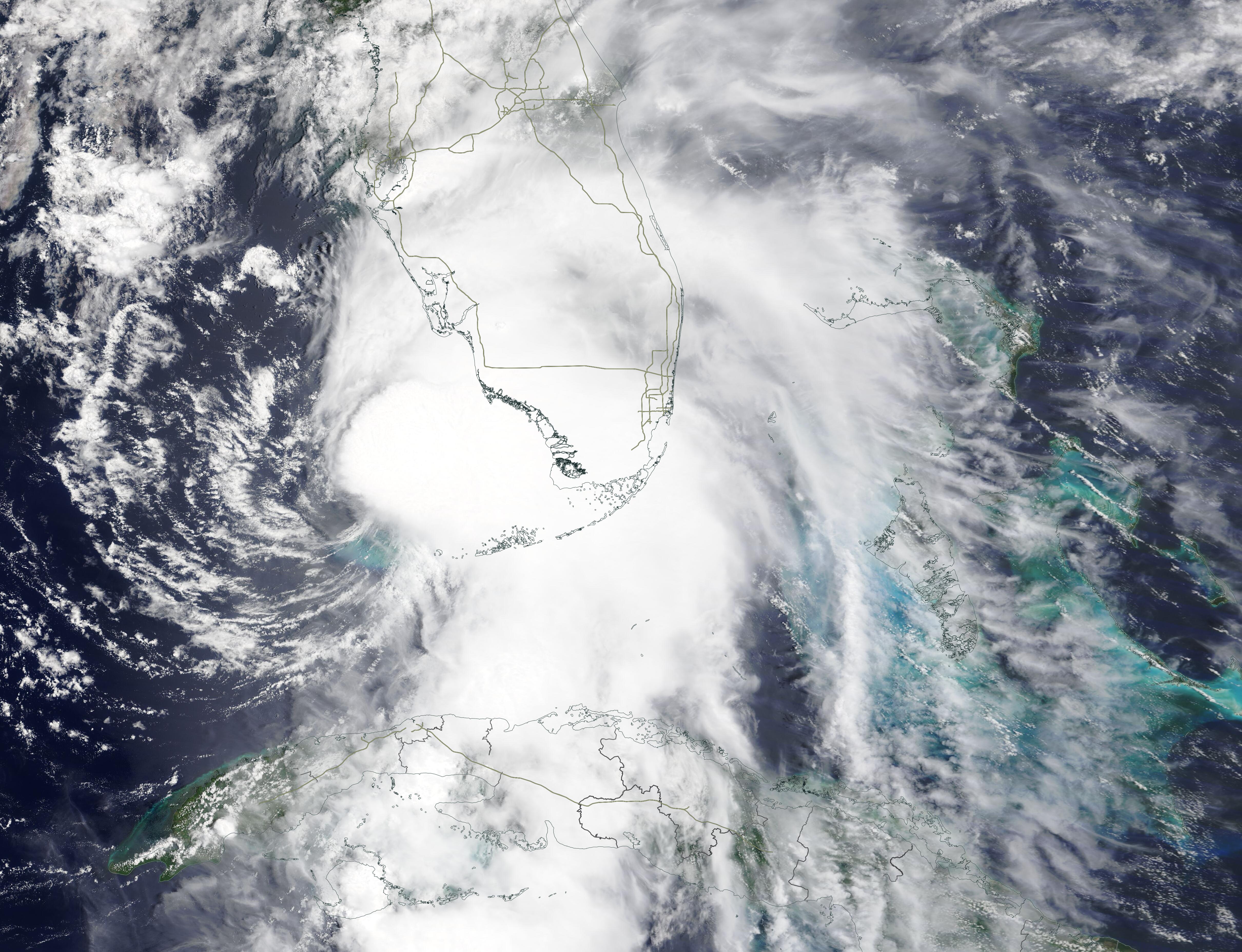
