
Images


August 22, 2021 - Fires in South America
 Tweet
Tweet
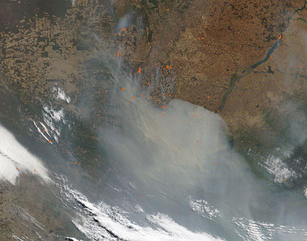
A thick shroud of smoke rose from hundreds of fires burning in Paraguay and southern Brazil in late August, 2021, blowing south-southeastward to completely hide a large swath of land from view. Using the NASA Worldview app, a conservative measurement of the area completely covered by smoke in this image alone is roughly 105,630 square miles (274,000 square kilometers)—an area larger than the U.S. state of Colorado.
On August 20, 2021, the Moderate Resolution Imaging Spectroradiometer (MODIS) on board NASA’s Terra satellite acquired this true-color image of fire and smoke in South America. Most of the fires, each marked by a red hot spot, are concentrated in northeastern Paraguay, especially in the Concepción Department. On August 21, Global Forest Watch (GFW) reports that in the most recent four weeks of data collected from Concepción, the region with the most significant burned was San Carolos, with 3.85 kilohectares burnt. The report continues, “This represents 67% of the total area burned in Concepción and is unusually high compared to the same period going back to 2001.”
The typical fire season in this region, which is agricultural in nature, begins in full force by late July and lasts about 18 weeks. Agricultural fires are used to manage land for crops or pasture and includes clearing old crops, preparing new fields for planting, opening forest land for new agricultural use, renewing pasture, and to meet many other management needs. Fire is a traditional tool that is easy, cheap and effective, but it comes with hazards such as intense smoke that carries hazards to humans, animals, and the environment. Fire is often a tool used in deforestation.
Soybeans and cassava are the major crops grown in this region and land is widely used for pasture for cattle, which is an important export. A new crop also appears to be gaining ground: marijuana. Local media reported that in October 2020, the Ministry of Environment and Sustainable Development stated that armed men were linked to marijuana cultivation in Caazapá National Park and obstructed fire fighters. On May 21, 2021, Monga Bay also reported that illegal marijuana traffickers were expanding illegal marijuana plantations within San Rafael National Park. Cattle and soybean continue to be the largest drivers of deforestation in Paraguay and surrounding regions.
Image Facts
Satellite:
Terra
Date Acquired: 8/20/2021
Resolutions:
1km (171.1 KB), 500m (597.6 KB), 250m (1.9 MB)
Bands Used: 1,4,3
Image Credit:
MODIS Land Rapid Response Team, NASA GSFC
