
Images


November 30, 2021 - Lake Urmia
 Tweet
Tweet
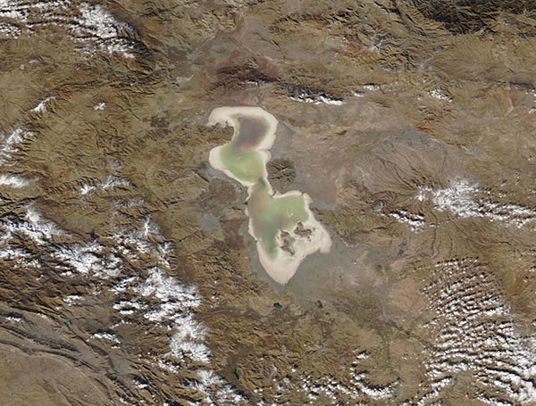
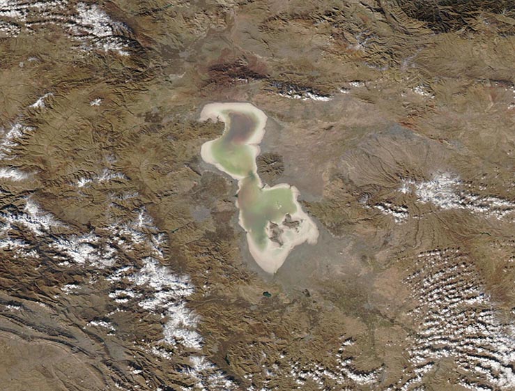
The hypersaline Lake Urmia, which sits in arid northwestern Iran, was once the second-largest saltwater lake in the Middle East. Farmland thrived along its banks, people fished and gathered fish in the salty waters, and the lake was a popular tourist destination.
Beginning by the 1970s, the lake began to shrink remarkably quickly, thanks to the impact of a complex mix of factors, including drought, rising temperatures, increasing water use for agriculture, and damming of tributaries. By 2013 the once-massive lake, with a surface area of about 6,100 square km (2,355 sq mi) had shrunk so much that the surface area had been reported as only 500 square kilometers (193 square miles).
In recent years, Iran’s government has made a dedicated effort to restore water to Lake Urmia. By April of 2021, the cost of the restoration efforts were estimated at about $1 billion U.S. dollars. Nature has cooperated to some extent, with torrential rains in 2018 and 2019 helping to replenish the dwindling waters. Increasing rains and increasing water levels have begun to make improvements in the environment—so much so that large numbers of flamingos were reported for the first time in many years in the summer of 2021. Despite improvements, Lake Urmia’s health has not yet recovered, and continued efforts are necessary to continue improvements.
On November 23, 2021, the Moderate Resolution Imaging Spectroradiometer (MODIS) on board NASA’s Aqua satellite acquired this true-color image of Lake Urmia. A broad band of pink-tinted minerals wraps all the way around the greenish waters while pale areas in the interior suggest very shallow water. These features suggest a wetland in process of drying up, although substantial water remains.
A single MODIS image gives an excellent view of this lake at one moment in time. Thanks to the NASA Worldview app, it’s easy to compare MODIS images taken on different days to see changes over time. On June 3, Lake Urmia was filled with red-tinted water (stained by bacteria or algae growth) with only a small edge of salt. The comparison, which can be viewed by clicking
here, shows Lake Urmia is once again suffering from significant evaporation.
The NASA Worldview app provides a satellite's perspective of the planet as it looks today and as it has in the past through daily satellite images. Worldview is part of NASA’s Earth Observing System Data and Information System. EOSDIS makes the agency's large repository of data accessible and freely available to the public.
Image Facts
Satellite:
Aqua
Date Acquired: 11/23/2021
Resolutions:
1km (61.2 KB), 500m (148.6 KB), 250m (308.1 KB)
Bands Used: 1,4,3
Image Credit:
MODIS Land Rapid Response Team, NASA GSFC
The hypersaline Lake Urmia, which sits in arid northwestern Iran, was once the second-largest saltwater lake in the Middle East. Farmland thrived along its banks, people fished and gathered fish in the salty waters, and the lake was a popular tourist destination. Beginning by the 1970s, the lake began to shrink remarkably quickly, thanks to the impact of a complex mix of factors, including drought, rising temperatures, increasing water use for agriculture, and damming of tributaries. By 2013 the once-massive lake, with a surface area of about 6,100 square km (2,355 sq mi) had shrunk so much that the surface area had been reported as only 500 square kilometers (193 square miles).
In recent years, Iran’s government has made a dedicated effort to restore water to Lake Urmia. By April of 2021, the cost of the restoration efforts were estimated at about $1 billion U.S. dollars. Nature has cooperated to some extent, with torrential rains in 2018 and 2019 helping to replenish the dwindling waters. Increasing rains and increasing water levels have begun to make improvements in the environment—so much so that large numbers of flamingos were reported for the first time in many years in the summer of 2021. Despite improvements, Lake Urmia’s health has not yet recovered, and continued efforts are necessary to continue improvements.
On November 23, 2021, the Moderate Resolution Imaging Spectroradiometer (MODIS) on board NASA’s Aqua satellite acquired this true-color image of Lake Urmia. A broad band of pink-tinted minerals wraps all the way around the greenish waters while pale areas in the interior suggest very shallow water. These features suggest a wetland in process of drying up, although substantial water remains.
A single MODIS image gives an excellent view of this lake at one moment in time. Thanks to the NASA Worldview app, it’s easy to compare MODIS images taken on different days to see changes over time. On June 3, Lake Urmia was filled with red-tinted water (stained by bacteria or algae growth) with only a small edge of salt. The comparison, which can be viewed by clicking here, shows Lake Urmia is once again suffering from significant evaporation.
The NASA Worldview app provides a satellite's perspective of the planet as it looks today and as it has in the past through daily satellite images. Worldview is part of NASA’s Earth Observing System Data and Information System. EOSDIS makes the agency's large repository of data accessible and freely available to the public.
Image Facts
Satellite:
Aqua
Date Acquired: 11/23/2021
Resolutions:
1km (61.2 KB), 500m (148.6 KB), 250m (308.1 KB)
Bands Used: 1,4,3
Image Credit:
MODIS Land Rapid Response Team, NASA GSFC
