Images
January 15, 2022 - Lake Manicouagan
Tweet
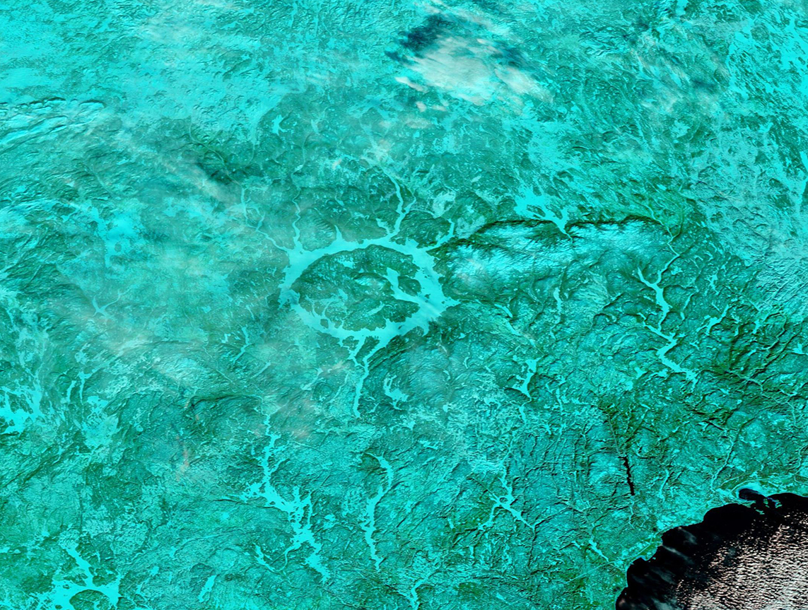
Once nominated as one of the “Seven Wonders of Canada”, the curiously circular Lake Manicouagan draws attention both from land-bound tourists and from space. Tourists and fishermen adore the lake for spectacular scenery and excellent salmon fishing. And the striking appearance of the “eye of Quebec” allows rapid orientation to astronauts and satellites, confirming that there is no other place on Earth quite like this striking structure. In fact, it was an astronaut, Marc Garneau, who nominated this reservoir for the Seven Wonders of Canada competition.
Lake Manicouagan spans an area of 750 square miles (1,942 sq. km) in central Quebec, Canada and has a volume of 33.5 cubic miles (139.8 cu km), making the reservoir the fifth largest in the world by volume. The large island in the center of the lake is called René-Levasseur Island and helps give the lake it’s eye-like appearance.
The lake’s peculiar appearance comes from its creation. Lake Manicouagan sits in an ancient and heavily eroded impact crater (astrobleme) from an asteroid which struck the Earth about 214 million years ago. The original diameter of the impact has been estimated to have been about 60 miles (100 km), and the size of the asteroid at about 3 miles (5 km) in diameter. Glaciation and other erosional processes reduced the extent of the crater, leaving the visible diameter at only 45 miles (72 km).
Manicouagan Reservoir lies within the remnant of an ancient eroded impact crater (astrobleme). The crater was formed following the impact of a 5 kilometres (3.1 mi) diameter asteroid which excavated a crater originally about 100 km (62 mi) wide although erosion and deposition of sediments have since reduced the visible diameter to about 72 km (45 mi). It is the sixth-largest confirmed impact crater known on earth. Mount Babel is interpreted as the central peak of the crater, formed by post-impact uplift. Lake Manicouagan is the sixth-largest confirmed impact crater on Earth.
The Moderate Resolution Imaging Spectroradiometer (MODIS) on board NASA’s Aqua satellite acquired this stunning false-color image of frozen Lake Manicouagan on January 11, 2022. In this type of image, using MODIS bands 7-2-1, vegetation appears green and snow or ice appears electric blue. Frigid weather has frozen Lake Manicouagan as well as other lakes and rivers in the region, while light snowfall sits on the surrounding landscape, colored by the vegetation beneath.
Image Facts
Satellite:
Terra
Date Acquired: 1/11/2022
Resolutions:
1km (472.6 KB), 500m (1.3 MB), 250m (844.9 KB)
Bands Used: 7,2,1
Image Credit:
MODIS Land Rapid Response Team, NASA GSFC


