
Images


January 16, 2022 - The Start of Something Big: Hunga Tonga-Hunga Ha'apai Volcano
 Tweet
Tweet
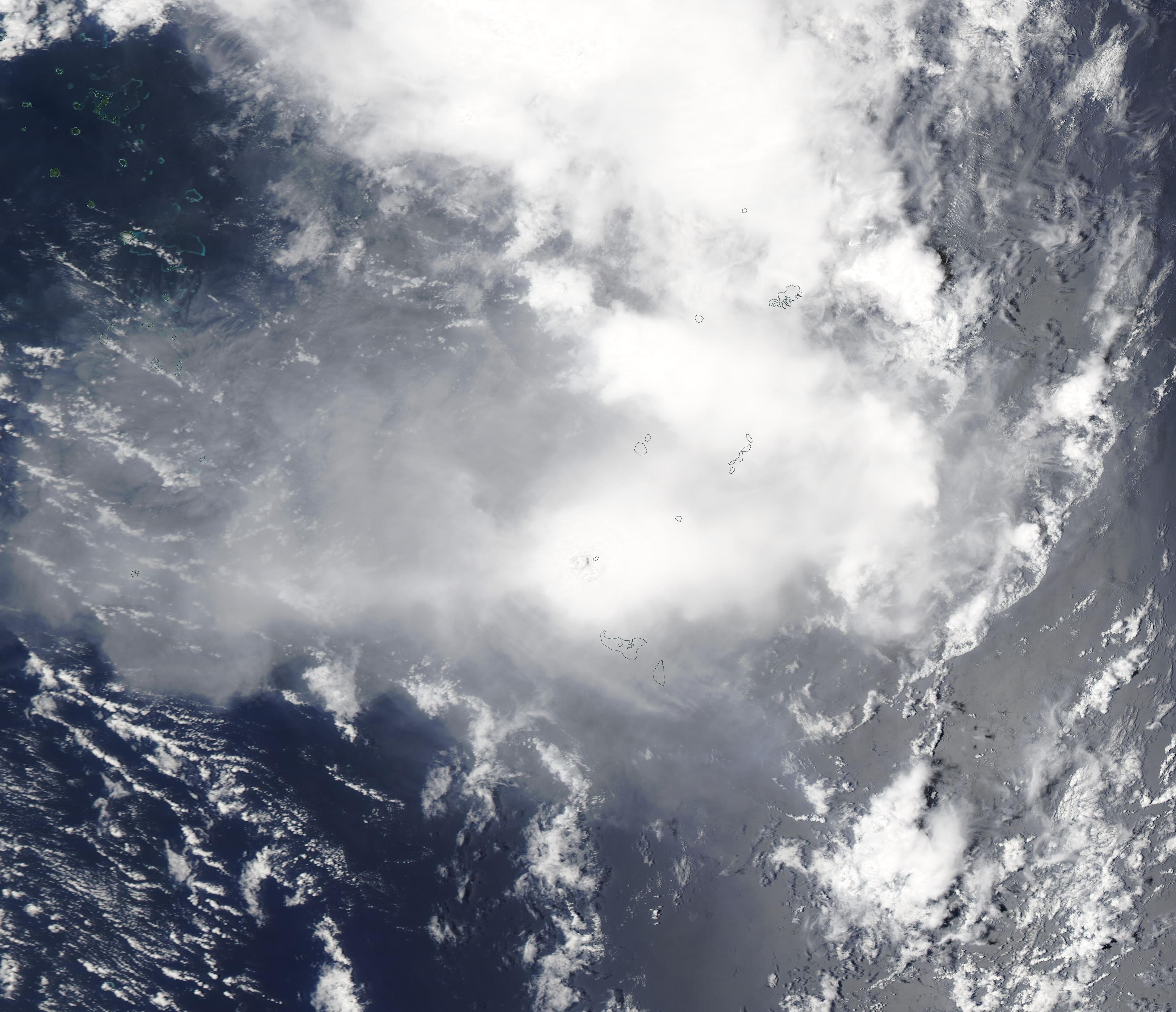
On January 13, 2022, the Moderate Resolution Imaging Spectroradiometer (MODIS) on board NASA’s Aqua satellite acquired a true-color image of the start of something big—a massive volcanic eruption on from an undersea volcano in Tonga that triggered tsunami waves and massive ash clouds. On January 15, coastal areas from New Zealand to Alaska felt the impact of tsunami waves from the massive eruption.
This image captures a large gas, steam, and ash cloud pouring from the Hunga Tonga-Hunga Ha’pai volcano on January 13, just before an explosive eruption flung a dark cloud of ash 55,000 feet (16,800 meters) into the air. Steam, gas, ash, and lava activity isn’t new at the volcano, which has been in a new eruptive phase since December 2021. However, the January 13 large ash eruption came after about a week of relative quiet at the volcano.
On January 14, the Volcanic Ash Advisory Center Wellington (VAAC) reported a very large eruption at Hunga Tonga-Hunga Ha’pai, based on satellite imagery. At that time, the steam obscured the ash plume and the height of the ash plume was unknown. According to the Global Alert and Disaster Coordination System (GDACS), a 5.8 magnitude earthquake was registered from Tonga on that day, at a depth of 5 km, with 800,000 people within 100 km of the quake.
By the morning of January 15, GDACS recorded a second large earthquake (4.5 magnitude) and the volcano exploded in a “major vent-clearing event”, according to a report from ABC NEWS in Australia. The eruption was heard in New Zealand, 1,300 miles away, and Alaska, which sits roughly 6,000 miles away. The powerful explosion—made even stronger by sizzling hot magma reacting with cold ocean water—triggered a tsunami. Waves washed over nearby islands, knocking down communication lines, flooding coastlines, and forcing evacuations from low-lying areas. Australia offered to send reconnaissance flights over Tonga’s islands to assess damage, but as of late on January 15, the thick plume of ash prevented such flights from occurring.
Tsunami waves coursed across the vast Pacific Ocean, bringing surges of more than 3 feet to Alaska, coastal flooding in California, and smaller surges in Oregon, Washington State, British Columbia, Mexico, South America, Hawaii, and Japan. By the late evening of January 15, tsunami warnings had been downgraded or cancelled along most of the Pacific basin. Some speculate that the January 15 eruption was among the strongest in the 21st century—a theory that will be tested as scientists sort through data and damage estimates over the next few weeks or months.
An astounding video of the massive eruption captured by NOAA's GOES West satellite on January 13 can be viewed
here.
Image Facts
Satellite:
Aqua
Date Acquired: 1/13/2022
Resolutions:
1km (593.1 KB), 500m (1.5 MB), 250m (948.8 KB)
Bands Used: 1,4,3
Image Credit:
MODIS Land Rapid Response Team, NASA GSFC
On January 13, 2022, the Moderate Resolution Imaging Spectroradiometer (MODIS) on board NASA’s Aqua satellite acquired a true-color image of the start of something big—a massive volcanic eruption on from an undersea volcano in Tonga that triggered tsunami waves and massive ash clouds. On January 15, coastal areas from New Zealand to Alaska felt the impact of tsunami waves from the massive eruption.
This image captures a large gas, steam, and ash cloud pouring from the Hunga Tonga-Hunga Ha’pai volcano on January 13, just before an explosive eruption flung a dark cloud of ash 55,000 feet (16,800 meters) into the air. Steam, gas, ash, and lava activity isn’t new at the volcano, which has been in a new eruptive phase since December 2021. However, the January 13 large ash eruption came after about a week of relative quiet at the volcano.
On January 14, the Volcanic Ash Advisory Center Wellington (VAAC) reported a very large eruption at Hunga Tonga-Hunga Ha’pai, based on satellite imagery. At that time, the steam obscured the ash plume and the height of the ash plume was unknown. According to the Global Alert and Disaster Coordination System (GDACS), a 5.8 magnitude earthquake was registered from Tonga on that day, at a depth of 5 km, with 800,000 people within 100 km of the quake.
By the morning of January 15, GDACS recorded a second large earthquake (4.5 magnitude) and the volcano exploded in a “major vent-clearing event”, according to a report from ABC NEWS in Australia. The eruption was heard in New Zealand, 1,300 miles away, and Alaska, which sits roughly 6,000 miles away. The powerful explosion—made even stronger by sizzling hot magma reacting with cold ocean water—triggered a tsunami. Waves washed over nearby islands, knocking down communication lines, flooding coastlines, and forcing evacuations from low-lying areas. Australia offered to send reconnaissance flights over Tonga’s islands to assess damage, but as of late on January 15, the thick plume of ash prevented such flights from occurring.
Tsunami waves coursed across the vast Pacific Ocean, bringing surges of more than 3 feet to Alaska, coastal flooding in California, and smaller surges in Oregon, Washington State, British Columbia, Mexico, South America, Hawaii, and Japan. By the late evening of January 15, tsunami warnings had been downgraded or cancelled along most of the Pacific basin. Some speculate that the January 15 eruption was among the strongest in the 21st century—a theory that will be tested as scientists sort through data and damage estimates over the next few weeks or months.
An astounding video of the massive eruption captured by NOAA's GOES West satellite on January 13 can be viewed here.
Image Facts
Satellite:
Aqua
Date Acquired: 1/13/2022
Resolutions:
1km (593.1 KB), 500m (1.5 MB), 250m (948.8 KB)
Bands Used: 1,4,3
Image Credit:
MODIS Land Rapid Response Team, NASA GSFC
