
Images


February 12, 2022 - Valley Fog in Oregon
 Tweet
Tweet
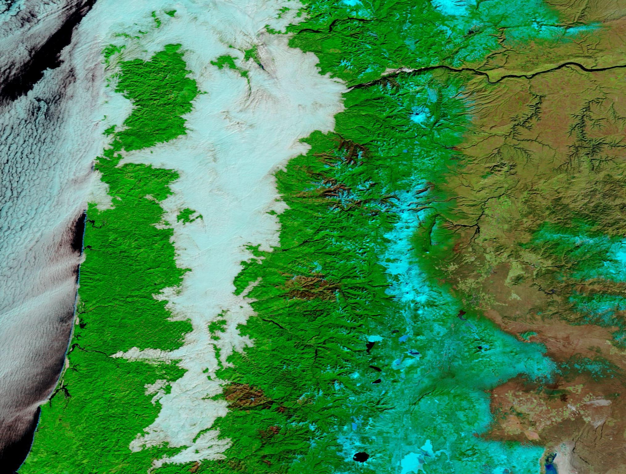
Dense fog blanketed Oregon’s Willamette Valley on February 10, 2022, stretching from Canyonville to Portland and snaking into adjacent valleys. On February 9, the National Weather Service (NWS) issued a warning for the Portland area, advising that areas of dense fog and icy conditions could create hazardous traveling conditions through the morning of February 10. According to the NWS, Cold and damp air remained trapped under a very strong inversion, resulting in widespread low clouds and fog. Areas of dense freezing fog were expected to form in areas between 500- and 1,500-feet elevation, with the potential of development fog below in a few places below 500 feet elevation.
The false-color image acquired by the Moderate Resolution Imaging Spectroradiometer (MODIS) on the morning of February 10 proved the predictions right on-target. This type of image uses a combination of infrared and visible light which helps separate fog (low cloud) from snow and ice. Snow appears electric blue while cloud/fog looks white. When fog or cloud is very cold and contains ice crystals, it may appear very pale electric blue. Open land looks brown; vegetation is bright green and deep water looks black. With this combination, it’s easy to see that cold cloud sits over the Pacific Ocean, low cloud drapes over the inland valley, and snow sits atop the high elevations in the Cascades. Brick-red areas in the greenery of the Cascades are burn scars, left behind by recent fires.
Fog is a low-lying type of cloud composed of tiny water droplets suspended in the air. The main difference between a cloud and fog is that the base of fog reaches the ground, while the base of a cloud is well above the surface. The difference between fog and mist relates to how much the suspended water droplets reduce visibility. Fog reduces visibility to less than 1 kilometer (0.6 miles). Mist also reduces visibility but never below 1 kilometer.
Radiation fog usually forms in clear, calm conditions at night. The cooling of the land surface chills the air close to the surface, reducing the air’s ability to hold moisture and trigging condensation and fog formation. In low-elevation areas, radiation fog usually fades as the Sun warms the land surface, but in higher-elevation areas valley fog can linger throughout the day.
Image Facts
Satellite:
Terra
Date Acquired: 2/10/2022
Resolutions:
1km (342.1 KB), 500m (935.8 KB), 250m (599 KB)
Bands Used: 7,2,1
Image Credit:
MODIS Land Rapid Response Team, NASA GSFC
