
Images


February 28, 2022 - Flooding in Madagascar
 Tweet
Tweet
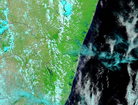
Heavy rains and destructive winds have battered the island nation of Madagascar during the opening weeks of 2022. In January 2022, a series of torrential tropical rainstorms were followed by tropical depression and storm Ana. Early February brought Cyclones Batsirai and Dumako to the island. When Tropical Cyclone Emnati made landfall along the eastern coast on February 22, it made the fifth time in six weeks that large storms formed over the Indian Ocean and then moved over Madagascar. Heavy flooding has followed the storms, both in the north and along the southeastern coast.
According to ReliefWeb, tropical Cyclone Emnati made landfall around in Mangatsiatra village in Fitovinany Region, with wind gusts of between 150 km/h and 200 km/h (93 mph and 124 mph). This is on the southeastern coast of the island. Rainfall in Mananjary, a town located well north of landfall, was recorded at 109 mm (4.6 inches) following Emnati. Emnati passed over areas that had been impacted by the torrential rains carried by Tropical Cyclone Batsirai just 18 days prior.
On February 25, 2022, the Moderate Resolution Imaging Spectroradiometer (MODIS) on board NASA’s Terra satellite acquired a false-color image highlighting flooding across southeastern Madagascar. This type of false-color image uses infrared and visible light to make it easy to separate water from land. Vegetation appears bright green, water looks dark, and cloud shows as white or pale blue. Black lines have been overlain on the image to mark regional boundaries. This image makes it clear that flooding is occurring all along the coastline and inland in Atsimo-Atsinanana. Several inland rivers also appear to be overflowing.
While this image gives a reliable view of the flooding that followed Cyclones Batsirai and Emnati, it is only one snapshot in time. To better understand change over time, it is helpful to compare images from before the storms and after. Thanks to the NASA Worldview app, this is as easy and clicking a link. To view a comparison of two false-color Terra MODIS images of the region (this one acquired on February 24, and one acquired on January 30), click here.
Image Facts
Satellite:
Terra
Date Acquired: 2/24/2022
Resolutions:
1km (75.1 KB), 500m (185 KB), 250m (453.9 KB)
Bands Used: 7,2,1
Image Credit:
MODIS Land Rapid Response Team, NASA GSFC
