
Images


April 29, 2022 - Flooding on the Red River
 Tweet
Tweet
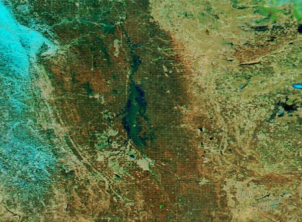
Each spring, as warming temperatures spur rapid melt of winter’s accumulated snow, people living along the Red River in Minnesota and North Dakota keep a wary eye on water levels and prepare for the all-too-common likelihood of flooding.
A typical spring thaw begins in the middle of March in the southern-most portions of the Red River basin and continues through mid- to late-April in the north. Although substantial flooding doesn’t occur every year, notable and damaging floods occur every few years. The flood of 1826, which devastated parts of Manitoba, Canada, is considered the largest flood of the Red River Valley, but it’s hardly the last extreme flooding event in the valley. Despite flood control measures along the river, the flood of 1997 destroyed almost all of Grand Forks, North Dakota and East Grand Forks, Minnesota, caused the evacuation of about 50,000 people, and caused about $3.5 billion dollars (U.S.) in damages along the Red River Valley in the United States. By these historical standards, the current flooding of the Red River is short of record-setting, at least so far. Nonetheless, the combination of heavy and rapid snow melt, combined with heavy rain in April 2022, has once again created a severe flooding in North Dakota and Minnesota.
On April 27, 2022, the Moderate Resolution Imaging Spectroradiometer (MODIS) on board NASA’s Aqua satellite acquired a false-color image that shows the extent of flooding along the Red River. This type of false-color image uses visible, near-infrared, and short-wave infrared (MODIS bands 7,2,1) to help distinguish water from the surrounding landscape. In this band combination, water appears dark inky-blue or black, vegetation looks bright green, and open land shows as tan or brown. In addition, snow and ice appears bright electric blue while cloud typically shows as bright white. However, small ice crystals carried in high-level clouds will give that type of cloud a light blue tint. With this image, it is clear that the Red River, which is normally described as a “slow moving and picturesque” river, with a channel that varies from 100-500 feet (30-150 meters) in width, has abundantly overflowed its banks to create substantial flooding all along the border between North Dakota (west) and Minnesota (east).
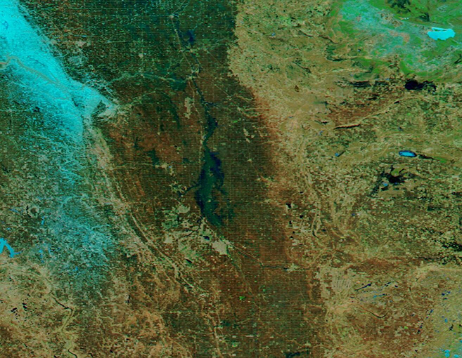
Although the impressive flooding is easily viewed in this single false-color image, to fully understand the extent of the flood this year as compared to a normal April, it is necessary to compare two views of the same region in two different years. In 2021, the spring melt was relatively mild, resulting in little flooding. Thanks to the NASA Worldview App, it is easy to view a roll-over comparison between two Aqua MODIS, false-color images of the same region on April 17, 2021, and the image above. In addition to the difference in river width, the 2022 image shows more snow and ice than 2021. To view the comparison, simply click here.
The NASA Worldview app provides a satellite's perspective of the planet as it looks today and as it has in the past through daily satellite images. Worldview is part of NASA’s Earth Observing System Data and Information System. EOSDIS makes the agency's large repository of data accessible and freely available to the public.
Image Facts
Satellite:
Aqua
Date Acquired: 4/27/2022
Resolutions:
1km (158.5 KB), 500m (407.2 KB), 250m (253.8 KB)
Bands Used: 7,2,1
Image Credit:
MODIS Land Rapid Response Team, NASA GSFC
Each spring, as warming temperatures spur rapid melt of winter’s accumulated snow, people living along the Red River in Minnesota and North Dakota keep a wary eye on water levels and prepare for the all-too-common likelihood of flooding.
A typical spring thaw begins in the middle of March in the southern-most portions of the Red River basin and continues through mid- to late-April in the north. Although substantial flooding doesn’t occur every year, notable and damaging floods occur every few years. The flood of 1826, which devastated parts of Manitoba, Canada, is considered the largest flood of the Red River Valley, but it’s hardly the last extreme flooding event in the valley. Despite flood control measures along the river, the flood of 1997 destroyed almost all of Grand Forks, North Dakota and East Grand Forks, Minnesota, caused the evacuation of about 50,000 people, and caused about $3.5 billion dollars (U.S.) in damages along the Red River Valley in the United States. By these historical standards, the current flooding of the Red River is short of record-setting, at least so far. Nonetheless, the combination of heavy and rapid snow melt, combined with heavy rain in April 2022, has once again created a severe flooding in North Dakota and Minnesota.
On April 27, 2022, the Moderate Resolution Imaging Spectroradiometer (MODIS) on board NASA’s Aqua satellite acquired a false-color image that shows the extent of flooding along the Red River. This type of false-color image uses visible, near-infrared, and short-wave infrared (MODIS bands 7,2,1) to help distinguish water from the surrounding landscape. In this band combination, water appears dark inky-blue or black, vegetation looks bright green, and open land shows as tan or brown. In addition, snow and ice appears bright electric blue while cloud typically shows as bright white. However, small ice crystals carried in high-level clouds will give that type of cloud a light blue tint. With this image, it is clear that the Red River, which is normally described as a “slow moving and picturesque” river, with a channel that varies from 100-500 feet (30-150 meters) in width, has abundantly overflowed its banks to create substantial flooding all along the border between North Dakota (west) and Minnesota (east).
Although the impressive flooding is easily viewed in this single false-color image, to fully understand the extent of the flood this year as compared to a normal April, it is necessary to compare two views of the same region in two different years. In 2021, the spring melt was relatively mild, resulting in little flooding. Thanks to the NASA Worldview App, it is easy to view a roll-over comparison between two Aqua MODIS, false-color images of the same region on April 17, 2021, and the image above. In addition to the difference in river width, the 2022 image shows more snow and ice than 2021. To view the comparison, simply click here.
The NASA Worldview app provides a satellite's perspective of the planet as it looks today and as it has in the past through daily satellite images. Worldview is part of NASA’s Earth Observing System Data and Information System. EOSDIS makes the agency's large repository of data accessible and freely available to the public.
Image Facts
Satellite:
Aqua
Date Acquired: 4/27/2022
Resolutions:
1km (158.5 KB), 500m (407.2 KB), 250m (253.8 KB)
Bands Used: 7,2,1
Image Credit:
MODIS Land Rapid Response Team, NASA GSFC
