
Images


May 7, 2022 - Flooding in Valencia
 Tweet
Tweet
According to several travel websites, the best time to visit Valencia, Spain is in April and May, the sun-filled days that are the “sweet spot full of warm weather and void of crazy crowds”. Whatever the average spring weather (and despite Valencia enjoying 300 sunny days each year, on average), the spring of 2022 has been extremely unkind to visitors and residents.
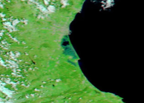
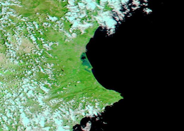
After an exceptionally wet spring, in which the Valencia region received 19.01 inches (483 mm) of rain since March 1, a severe storm brought torrential rain to the southern half of Spain in early May, causing extreme flooding which shut down roads, blocked tunnels, and caused some residents to require rescue from the rising waters. According to AccuWeather, within the first three days of May, Valencia recorded 8.58 inches of rain. This is more than five times the month’s average amount of rain. Then, on May 4, the deluge somehow worsened to drench the city with the highest 24-hour rainfall total for the month of May since 1871, with 7.92 inches (201.1 mm) of rainfall recorded on that day.
On May 5, the Moderate Resolution Imaging Spectroradiometer (MODIS) on board NASA’s Aqua satellite acquired a false-color image of the Valencia region. This type of false-color image uses visible and infrared light (MODIS bands 7,2, and 1) to help separate water from land and vegetation: water appears dark blue, vegetation is bright green, open land looks tan, and gray pixels mark cities. In this image, the large city of Valencia can be seen along the coast of the Mediterranean Sea, just north of the lagoon of the Albufera National Park. Although it is difficult to appreciate the flooding in the gray pixels, the southern wetlands near the towns found in the Pobles del Sud region are heavily inundated.
This one image adequately shows extensive flooding, but to better appreciate the amount of change over time it is helpful to compare two images taken at different times. Thanks to the NASA Worldview App, it is simple compare the image acquired by Aqua MODIS on May 5, just after the peak of the floods and one acquired by Aqua MODIS on April 17, prior to the most torrential May rains. To view the roll-over comparison, simply click here
The NASA Worldview app provides a satellite's perspective of the planet as it looks today and as it has in the past through daily satellite images. Worldview is part of NASA’s Earth Observing System Data and Information System. EOSDIS makes the agency's large repository of data accessible and freely available to the public.
Image Facts
Satellite:
Aqua
Date Acquired: 5/5/2022
Resolutions:
1km (98.2 KB), 500m (209.6 KB), 250m (118.8 KB)
Bands Used: 1,4,3
Image Credit:
MODIS Land Rapid Response Team, NASA GSFC
According to several travel websites, the best time to visit Valencia, Spain is in April and May, the sun-filled days that are the “sweet spot full of warm weather and void of crazy crowds”. Whatever the average spring weather (and despite Valencia enjoying 300 sunny days each year, on average), the spring of 2022 has been extremely unkind to visitors and residents.
After an exceptionally wet spring, in which the Valencia region received 19.01 inches (483 mm) of rain since March 1, a severe storm brought torrential rain to the southern half of Spain in early May, causing extreme flooding which shut down roads, blocked tunnels, and caused some residents to require rescue from the rising waters. According to AccuWeather, within the first three days of May, Valencia recorded 8.58 inches of rain. This is more than five times the month’s average amount of rain. Then, on May 4, the deluge somehow worsened to drench the city with the highest 24-hour rainfall total for the month of May since 1871, with 7.92 inches (201.1 mm) of rainfall recorded on that day.
On May 5, the Moderate Resolution Imaging Spectroradiometer (MODIS) on board NASA’s Aqua satellite acquired a false-color image of the Valencia region. This type of false-color image uses visible and infrared light (MODIS bands 7,2, and 1) to help separate water from land and vegetation: water appears dark blue, vegetation is bright green, open land looks tan, and gray pixels mark cities. In this image, the large city of Valencia can be seen along the coast of the Mediterranean Sea, just north of the lagoon of the Albufera National Park. Although it is difficult to appreciate the flooding in the gray pixels, the southern wetlands near the towns found in the Pobles del Sud region are heavily inundated.
This one image adequately shows extensive flooding, but to better appreciate the amount of change over time it is helpful to compare two images taken at different times. Thanks to the NASA Worldview App, it is simple compare the image acquired by Aqua MODIS on May 5, just after the peak of the floods and one acquired by Aqua MODIS on April 17, prior to the most torrential May rains. To view the roll-over comparison, simply click here
The NASA Worldview app provides a satellite's perspective of the planet as it looks today and as it has in the past through daily satellite images. Worldview is part of NASA’s Earth Observing System Data and Information System. EOSDIS makes the agency's large repository of data accessible and freely available to the public.
Image Facts
Satellite:
Aqua
Date Acquired: 5/5/2022
Resolutions:
1km (98.2 KB), 500m (209.6 KB), 250m (118.8 KB)
Bands Used: 1,4,3
Image Credit:
MODIS Land Rapid Response Team, NASA GSFC
