
Images


May 8, 2022 - Expanding Burn Scars in New Mexico
 Tweet
Tweet
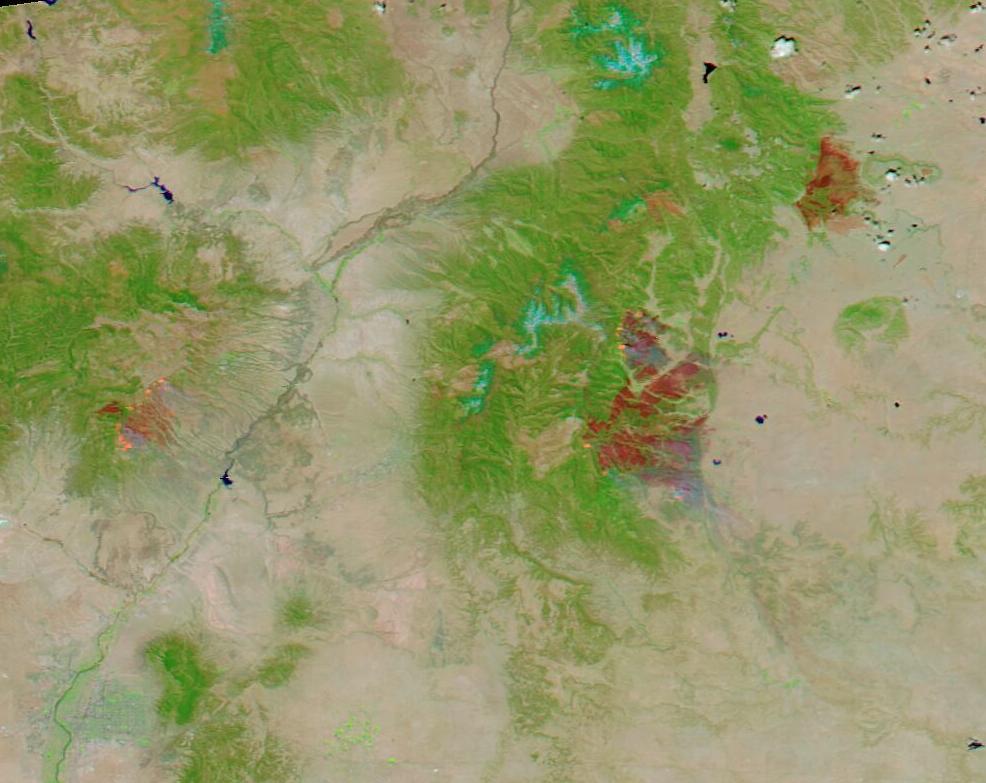
Many of New Mexico’s wildfires continue to burn strongly through the first week of May 2022, leaving behind expanding scars that can easily be seen from space. On May 5, 2022, the Moderate Resolution Imaging Spectroradiometer (MODIS) on board NASA’s Terra satellite acquired a false-color image of the burn scar from three of the northern New Mexico fires. The Calf Canyon and Hermit’s Peak complex is the largest, with the Cerro Pelado fire to the west (left) and the Cooks Peak fire to the northeast.
By using visible and near-infrared light (bands 7,2,1) burn scars – which may appear black, brown, or brick red - stand out in stark contrast to vegetation, which appears bright green. Open land appears tan, deep water is colored deep blue and clouds, when present, may appear either white or tinted with electric blue. The color variation in burn scars depends on type of vegetation burned, the completeness of the burn, the amount of residue remaining after the burn, and the age of the burn. These three large burn scars all are a variation on brick red, indicating freshly burned area. At the edges of some fires, particularly the Cerra Pelado and the Calf Canyon and Hermits Peak complex, orange areas indicate actively burning fires.
The Cerro Pelado fire was first reported on April 22 in timber and brush in the Santa Fe National Forest. On May 7, it had burned 33,163 acres, which is 15,308 acres more than on May 2 and is only 11 percent contained. The Cook’s Peak fire ignited on April 17 from an undetermined caused. It has burned 59, 379 acres, or only 300 acres more than on May 2, and has now reached 97 percent containment.
The Calf Canyon fire began on April 19, and the cause is under investigation. On April 6, the Hermits Peak fire began as a prescribed burn in part of the Sant Fe National Forest, but erratic, gusty winds blew it out of control. Strong winds on April 22-23 pushed the fire through steep terrain and caused a merger with the Calf Canyon fire, creating a fire complex with more than 180 miles of perimeter. On May 2, the fire complex had scorched 120,653 acres in size, but as of May 7, the fire stretches over 170,665 acres and is still only 21 percent contained.
While this single image shows dramatic burn scars and continuing fire expansion, the change is burn scar is best visualized by comparing two images acquired on two different days. Thanks to the NASA Worldview App, a roll-over comparison of MODIS false-color images of northern New Mexico acquired on May 1, 2022, and this one, acquired on May 5 can be found here,
NASA's Earth Observing System Data and Information System (EOSDIS) Worldview application provides the capability to interactively browse over 700 global, full-resolution satellite imagery layers and then download the underlying data. Many of the available imagery layers are updated within three hours of observation, essentially showing the entire Earth as it looks "right now".
Image Facts
Satellite:
Terra
Date Acquired: 5/5/2022
Resolutions:
1km (76.6 KB), 500m (169.2 KB), 250m (89.2 KB)
Bands Used: 7,2,1
Image Credit:
MODIS Land Rapid Response Team, NASA GSFC
