
Images


May 9, 2022 - Great Slave Lake and the Simpson Islands
 Tweet
Tweet
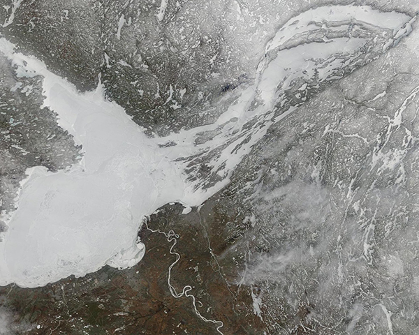
After winter ice-up in November, cold spring weather across the Northwest Territories typically allows ice to linger on the Great Slave Lake through mid-May. The eight-month hard freeze can make it difficult to find time to enjoy summer-time recreational activities that draw visitors to the lake, such as boating, kayaking, fishing. However, the massive lake is a year-round wonderland, allowing hardy visitors and locals to enjoy ice fishing, snowmobiling, snowshoeing, cross country skiing, and even dog-sledding in even the coldest months.
The Great Slave Lake is the second-largest lake located in Canada, the fifth-largest in North America, and the tenth-largest lake in the world by area. It is also the deepest lake in North America, with depths plunging to 2,027 feet (616 meters). The city of Yellowknife, the capital of and only large city in Northwest Territories, sits on the northern shore of Great Slave Lake, providing home to slightly more than 20,000 residents and a stopping-off point for thousands of tourists each year. Yellowknife sits only about 250 miles (400 km) south of the Arctic Circle. The First Nation villages of Edzo, Rae and Dettah are also located on the northern shore.
On May 5, 2022, the Moderate Resolution Imaging Spectroradiometer (MODIS) on board NASA’s Terra satellite acquired a true-color image of the frozen Great Slave Lake. A V-shaped inlet on the north shore marks the Yellowknife Bay, the location of the city of Yellowknife. The eastern section of the lake, called the East Arm, stretches to the northeast and is broken up by a series of rugged islands known as the Simpson Islands. These steep, cliff-like islands provide spectacular scenery for those who fish the very productive waters near the islands. The winding, frozen river flowing into the southern section of the lake is the Slave River. The south shore of the Great Slave Lake near the delta of the Slave River inlet has been recognized as an Important Bird and Biodiversity Area (IBA) by Birdlife International in honor of the tens of thousands of birds that stop by the area during migration or stop and breed during the short summer months.
Image Facts
Satellite:
Terra
Date Acquired: 5/5/2022
Resolutions:
1km (125.8 KB), 500m (382.3 KB), 250m (1 MB)
Bands Used: 1,4,3
Image Credit:
MODIS Land Rapid Response Team, NASA GSFC
