
Images


June 16, 2022 - Rapidly Shrinking Great Salt Lake
 Tweet
Tweet
The Great Salt Lake is an iconic feature of the state of Utah, U.S.A., creating a huge draw for tourists and local residents alike who long to experience the buoyancy of the saline waters, to sunbathe in the sand, to watch birds, or just generally soak in the uniqueness of a visit to the large, life-sustaining oasis that sits in an increasingly dry landscape. As wonderful as the lake is to experience, the health of the lake also is a foundation of the health of a wider ecosystem. The salinity of the lake is crucial to supporting a population of algae that feed brine shrimp, a species critical to feeding birds that flock to the shores during migration and breeding, as well as provide a profitable industry to humans who sell the shrimp and eggs commercially. On a broader scale, the water in the lake contributes to the winter snowpack in the Wasatch Mountains, and that snowpack is vital to the well-being of agriculture and human life in the increasingly-populated valley.
The description published on the website of the Utah Department of Natural Resources, Division of Water Resources probably sums up the importance of the Great Salt Lake best, “The ecology of the lake is an extraordinary example of the rich web of relationships between people, land, water, food and survival. The 15,000 square miles of various water environments, remote islands and shorelines, with 400,000 acres of wetlands, provide habitat for plants, brine shrimp, reptiles, amphibians, mammals, shorebirds and waterfowl. Birds rely on the lake, a critical link in the Pacific Flyway between North and South America. Every year 10 million birds from 338 different species come to rest, eat and breed during migrations of a thousand miles or more. With the decline of other lakes, GSL is increasingly important to these species.”
Unfortunately, the Great Salt Lake is in trouble.
Increasing diversion of the water of three rivers feeding the lake for human use and agricultural purposes means less inflow to the lake. Increasingly warm climate and a long-standing drought mean more water evaporating from the lake, which increases salinity as well as shrinks the size of the lake. Shrinking size means more dry lake bed, which contains high levels of arsenic and other toxic materials, is exposed and available to be lofted into the air as dust. A shrinking lake also means less water available to form precious winter snowpack, which impacts the welfare of humans who depend on water from the mountains and also impacts the ability of the Great Salt Lake to refresh from melting snowpack. Increasing salinity means that the lake water will become unlivable for many species of algae, which may cause brine shrimp to disappear. The U.S. Drought monitor on June 9, 2022, shows that 100 percent of Utah is in at least severe drought, with roughly 90 percent of the state in Extreme or Exceptional drought. “Exceptional drought” is the U.S. Drought monitor’s highest level of drought. They do not measure anything greater.
On July 23, 2021, the Great Salt Lake in Utah reached its lowest water level on record when the U.S. Geological Survey (USGS) gauge at the Saltair boat harbor at the southern end of the lake recorded the average daily level at 4,191.3 feet (1,277.5 meters) above sea level, the lowest mark since measurements began in 1875. The previous low was set in 1963. The Utah Division of Water Resources stated another record low was reached on October 15-18, 2021, when the water level dropped to 4,190.2 feet (1,277.2 meters). They expected the lake to experience a new low in the summer of 2022.
They didn't have to wait that long.
On June 15, 2022, the USGS website reports that the gauge at the Saltair boat harbor measured 4,186.80 feet. (1,276.1 meters).
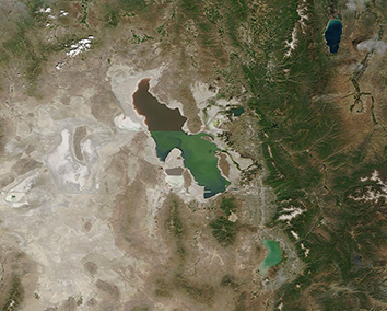
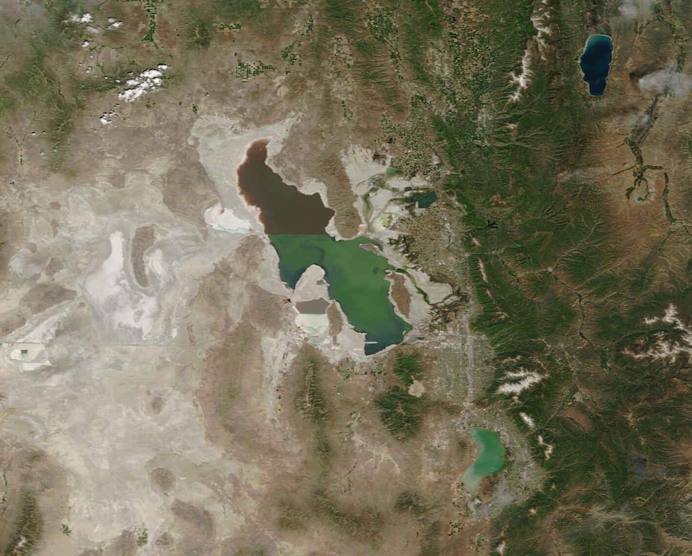
The Moderate Resolution Imaging Spectroradiometer (MODIS) on board NASA’s Terra satellite acquired a true-color image of the Great Salt Lake on June 15, 2022. The color difference between the two end of the lake is caused by a railroad line that runs across the lake, which obstructs normal mixing of lake water. The northern section is much saltier than the southern section (28 percent vs. 6-27 percent, respectively). Different species of algae live in the more saline North Arm than in the South Arm and this species difference is reflected in the color.
To truly appreciate change over time, it is necessary to compare different images acquired by the same instrument on different days. Thanks to the NASA Worldview App, it is simple to create roll-over comparisons between two Terra MODIS images, one acquired on June 15, 2022, and one acquired only a few days short of two years earlier, on June 24, 2020. To interact with the image, simply click on the arrow (or in the box) and scroll back and forth. The difference in such a short time is easily visible, and quite sobering.
Image Facts
Satellite:
Terra
Date Acquired: 6/15/2022
Resolutions:
1km (128.4 KB), 500m (333.9 KB), 250m (221.2 KB)
Bands Used: 1,4,3
Image Credit:
MODIS Land Rapid Response Team, NASA GSFC
The Great Salt Lake is an iconic feature of the state of Utah, U.S.A., creating a huge draw for tourists and local residents alike who long to experience the buoyancy of the saline waters, to sunbathe in the sand, to watch birds, or just generally soak in the uniqueness of a visit to the large, life-sustaining oasis that sits in an increasingly dry landscape. As wonderful as the lake is to experience, the health of the lake also is a foundation of the health of a wider ecosystem. The salinity of the lake is crucial to supporting a population of algae that feed brine shrimp, a species critical to feeding birds that flock to the shores during migration and breeding, as well as provide a profitable industry to humans who sell the shrimp and eggs commercially. On a broader scale, the water in the lake contributes to the winter snowpack in the Wasatch Mountains, and that snowpack is vital to the well-being of agriculture and human life in the increasingly-populated valley.
The description published on the website of the Utah Department of Natural Resources, Division of Water Resources probably sums up the importance of the Great Salt Lake best, “The ecology of the lake is an extraordinary example of the rich web of relationships between people, land, water, food and survival. The 15,000 square miles of various water environments, remote islands and shorelines, with 400,000 acres of wetlands, provide habitat for plants, brine shrimp, reptiles, amphibians, mammals, shorebirds and waterfowl. Birds rely on the lake, a critical link in the Pacific Flyway between North and South America. Every year 10 million birds from 338 different species come to rest, eat and breed during migrations of a thousand miles or more. With the decline of other lakes, GSL is increasingly important to these species.”
Unfortunately, the Great Salt Lake is in trouble.
Increasing diversion of the water of three rivers feeding the lake for human use and agricultural purposes means less inflow to the lake. Increasingly warm climate and a long-standing drought mean more water evaporating from the lake, which increases salinity as well as shrinks the size of the lake. Shrinking size means more dry lake bed, which contains high levels of arsenic and other toxic materials, is exposed and available to be lofted into the air as dust. A shrinking lake also means less water available to form precious winter snowpack, which impacts the welfare of humans who depend on water from the mountains and also impacts the ability of the Great Salt Lake to refresh from melting snowpack. Increasing salinity means that the lake water will become unlivable for many species of algae, which may cause brine shrimp to disappear. The U.S. Drought monitor on June 9, 2022, shows that 100 percent of Utah is in at least severe drought, with roughly 90 percent of the state in Extreme or Exceptional drought. “Exceptional drought” is the U.S. Drought monitor’s highest level of drought. They do not measure anything greater.
On July 23, 2021, the Great Salt Lake in Utah reached its lowest water level on record when the U.S. Geological Survey (USGS) gauge at the Saltair boat harbor at the southern end of the lake recorded the average daily level at 4,191.3 feet (1,277.5 meters) above sea level, the lowest mark since measurements began in 1875. The previous low was set in 1963. The Utah Division of Water Resources stated another record low was reached on October 15-18, 2021, when the water level dropped to 4,190.2 feet (1,277.2 meters). They expected the lake to experience a new low in the summer of 2022.
They didn't have to wait that long.
On June 15, 2022, the USGS website reports that the gauge at the Saltair boat harbor measured 4,186.80 feet. (1,276.1 meters).
The Moderate Resolution Imaging Spectroradiometer (MODIS) on board NASA’s Terra satellite acquired a true-color image of the Great Salt Lake on June 15, 2022. The color difference between the two end of the lake is caused by a railroad line that runs across the lake, which obstructs normal mixing of lake water. The northern section is much saltier than the southern section (28 percent vs. 6-27 percent, respectively). Different species of algae live in the more saline North Arm than in the South Arm and this species difference is reflected in the color.
To truly appreciate change over time, it is necessary to compare different images acquired by the same instrument on different days. Thanks to the NASA Worldview App, it is simple to create roll-over comparisons between two Terra MODIS images, one acquired on June 15, 2022, and one acquired only a few days short of two years earlier, on June 24, 2020. To interact with the image, simply click on the arrow (or in the box) and scroll back and forth. The difference in such a short time is easily visible, and quite sobering.
Image Facts
Satellite:
Terra
Date Acquired: 6/15/2022
Resolutions:
1km (128.4 KB), 500m (333.9 KB), 250m (221.2 KB)
Bands Used: 1,4,3
Image Credit:
MODIS Land Rapid Response Team, NASA GSFC
