
Images


June 24, 2022 - Thousands of Fires in Central Africa
 Tweet
Tweet
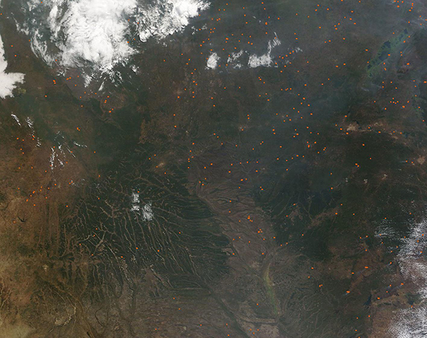
Many thousands of fires burned across Central Africa in late June 2022. The Moderate Resolution Imaging Spectroradiometer (MODIS) on board NASA’s Terra satellite acquired a true-color image showing the landscape of Democratic Republic of Congo (north), Angola (southwest), and Zambia (southeast) speckled with red hot spots. A gray pall, created by airborne smoke, covers most of the region and is heaviest in the northeast.
These hot spots mark areas where the thermal bands on the MODIS instrument detected high temperatures. When combined with typical smoke, as in this image, such hot spots are diagnostic for actively burning fire.
While it is not possible to know the cause of a fire from a satellite image, the widespread nature, location, and time of year makes it likely that these fires are agricultural. Fire is an integral part of traditional agricultural practices used in many parts of the world, including Central Africa. Farmers use fire to clear land for new cropland or pasture, to freshen existing pasture, and to burn debris from cropland to prepare for new planting. This practice is both inexpensive and low tech, making it available to small farmers. Unfortunately, fire generates smoke which can be hazardous to the health of humans and animals. Agricultural fires also can escape containment and become wildfires, which can consume vast amounts of acreage.
The peak fire season in Democratic Republic of the Congo, Angola, and Zambia, the peak fire season typically begins in early June and lasts around 15 weeks.
Image Facts
Satellite:
Terra
Date Acquired: 6/22/2022
Resolutions:
1km (191.2 KB), 500m (685.3 KB), 250m (2.3 MB)
Bands Used: 1,4,3
Image Credit:
MODIS Land Rapid Response Team, NASA GSFC
