Images
July 2, 2022 - Smoke over Alaska and Canada
Tweet
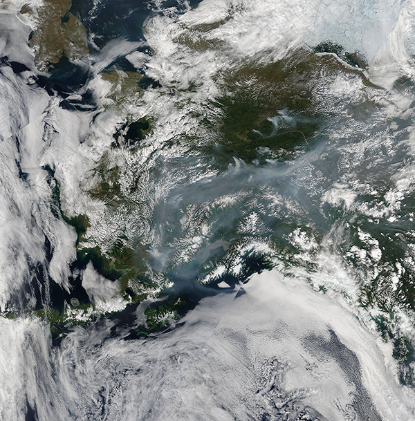
An early and active fire season filled the air over Southern Alaska with smoke in late June 2022. The Moderate Resolution Imaging Spectroradiometer (MODIS) on board NASA’s Terra satellite acquired a true-color image of the smoky scene on June 29.
Abundant cloud cover over the Gulf of Alaska (south), the Bering Sea (southwest), the Chukchi Sea (northwest) and the Beaufort Sea (northeast), as well as scattered “popcorn” clouds over Alaska and snow clinging to high elevations complicate the scene, making it difficult to pinpoint landmarks. However, the sediment-filled Cook Inlet, located near the center of the image, gives a good reference point for orientation. The city of Anchorage sits at the tip of Cook Inlet. The smoke stretches from Southwestern Alaska, well west of Cook Inlet, to Yukon, Canada in the east, a span of more than 600 miles (966 km).
According UAFSmoke on July 1, data from the Alaska Interagency Coordination Center was currently tracking 382 fires in Alaska. These fires were of all types: active, smoldering, or in the process of being demobilized.
Inciweb Incident Information System reports only 6 large fires on that same date, but some of these fires are massive. The East Fork Fire, which reached 100% containment on June 25 had burnt 250,725 Acres since May 31. The Line Complex Fire, burning in an isolated area west of Cook Inlet—likely where the heaviest smoke is found in this image—is made up of eight staffed and ten unstaffed fires, with a total combined size of 715,595 acres. These were all ignited by lightning strikes in very dry vegetation. Red Flag warnings across most of Southern Alaska will continue, thanks to warm, dry weather and high winds.
Image Facts
Satellite:
Terra
Date Acquired: 6/19/2022
Resolutions:
1km (3.6 MB), 500m (11.3 MB), 250m (8.1 MB)
Bands Used: 1,4,3
Image Credit:
MODIS Land Rapid Response Team, NASA GSFC


