
Images


July 16, 2022 - Tropical Storm Darby Approaches Hawaii
 Tweet
Tweet
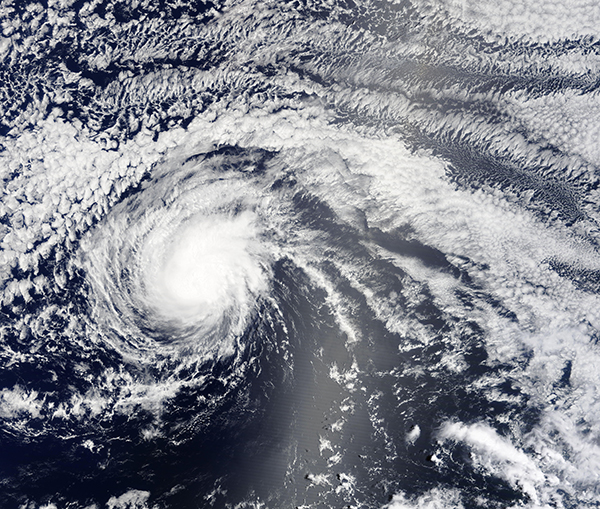
Once a fierce Category 4 hurricane carrying winds of 140 mph (225 km/h), Darby had weakened to tropical storm status as it approached the Big Island of Hawaii in mid-July 2022. The Moderate Resolution Imaging Spectroradiometer (MODIS) on board NASA’s Terra satellite acquired a true-color image of Tropical Storm Darby on the morning of July 15.
At 11:00 a.m. EDT (1500 UTC) July 15, the National Hurricane Center (NHC) advised that Darby had just transitioned from a hurricane to a tropical storm, with maximum sustained winds of 70 mph (110 km/h). It was located over the Pacific Ocean about 610 mi (980 km) east southeast of Hilo, Hawaii and about 810 miles (1,305 km) east southeast of Honolulu, Hawaii. Darby was moving westward at 16 mph (26 km/h).
Twelve hours later, at 11:00 p.m. EDT July 15 (0300 UTC July 16), Tropical Storm Darby’s maximum sustained winds had dropped to 45 mph (75 km/h) as it sped westward at 20 mph (31 km/h). The storm was located about 400 mi (640 km) east southeast of Hilo and 605 miles (975 km) east southeast of Honolulu, Hawaii.
Although landfall is not expected, large swells generated by Darby are expected to affect portions of the Hawaiian Islands over the weekend. The NHC advises that the swells are likely to produce hazardous surf and dangerous rip current conditions. It is also likely that the parts of Hawaii may see 2-4 inches (5-10 cm) of rain, especially along the windward area of the Big Island and windward sections of Maui. Some flooding may occur in low-lying sections of these areas.
Darby formed over the Pacific Ocean off the coast of Central America on July 9. As it moved northwestward, it began to intensify. On July 10, Darby became a Category 1 hurricane then underwent rapid intensification. By 5:00 p.m. EDT (2100 UTC) on July 11, the National Hurricane Center declared that Darby was “still small but now a mighty Category 4 hurricane”. At that time, Hurricane Darby reached peak strength, carrying maximum sustained winds of 140 mph 9220 km/h). It was located about 1,135 miles (1,830 km) west southwest of the southern tip of Baja California, Mexico and was moving westward at 15 mph (24 km/h). By July 12, Hurricane Darby had begun the weakening trend that still continues.
Image Facts
Satellite:
Aqua
Date Acquired: 7/14/2022
Resolutions:
1km (7.9 MB), 500m (7.9 MB), 250m (5.9 MB)
Bands Used: 1,4,3
Image Credit:
MODIS Land Rapid Response Team, NASA GSFC
