
Images


July 28, 2022 - Clouds around Isla Guadalupe
 Tweet
Tweet
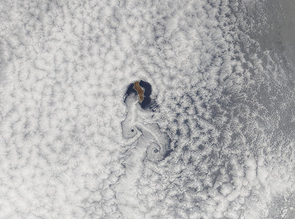
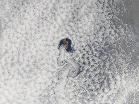
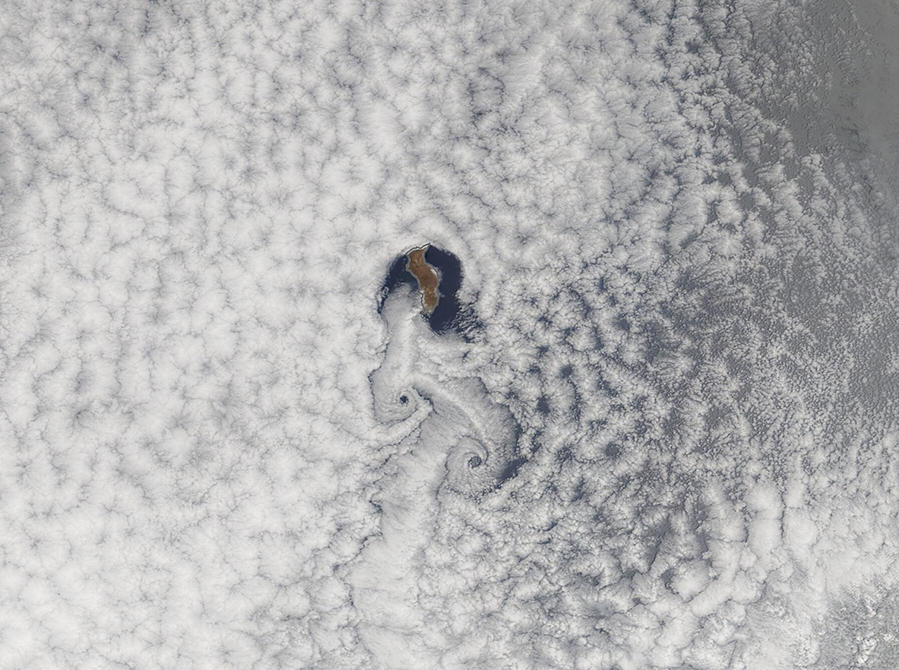
Isla Guadalupe sits in the Pacific Ocean off about 150 (240 km) off the coast of Baja California, Mexico. Only 22 miles (35.4 km) long and 6 miles (9.6 km) wide, the broad northern face of the island juts 4,257 feet (1,297.5 km) above sea level.
Winds are frequent in this section of the Pacific Ocean, as are the massive banks of marine stratocumulus cloud which frequently form off the western coast of continents. When wind strikes an immobile object—such as the face of Isla Guadalupe—the flow of the wind is disrupted, causing it to flow around the object and swirls of turbulent air develop on the lee side. In cloud-free skies, the flow of air is invisible. Cloudy skies, however, create a perfect canvas to bring the motion into view.
On July 26, 2022, the Moderate Resolution Imaging Spectroradiometer (MODIS) on board NASA’s Terra satellite captured a stunning true-color image showing the atmospheric disruption caused by a small, tall island painted into the clouds. Clouds can be seen pressing against the broad, tall northern face of the island. As air is violently pushed eastward and westward around the volcanic obstruction, clouds are also pushed away from the island. As the air passes Isla Guadalupe, the spinning air creates glorious patterns in the clouds.
These repetitive and predictable patterns are known as Von Kármán vortices. They are named after Theodore von Kármán—an accomplished mathematician, aerospace engineer, and one of NASA Jet Propulsion Laboratory’s founders—who was the first to mathematically describe the formation of these vortices behind immobile objects. Von Kármán vortices will only form under certain conditions of air speed, atmospheric stability, and obstacle size. Conditions around Isla Guadalupe are often ideal for production of these gorgeous swirls, especially in June, July, and August, when they occur almost every day.
Image Facts
Satellite:
Terra
Date Acquired: 7/26/2022
Resolutions:
1km (152.6 KB), 500m (448.5 KB), 250m (320.5 KB)
Bands Used: 1,4,3
Image Credit:
MODIS Land Rapid Response Team, NASA GSFC
