
Images


September 2, 2022 - Wildfires in the Western United States
 Tweet
Tweet
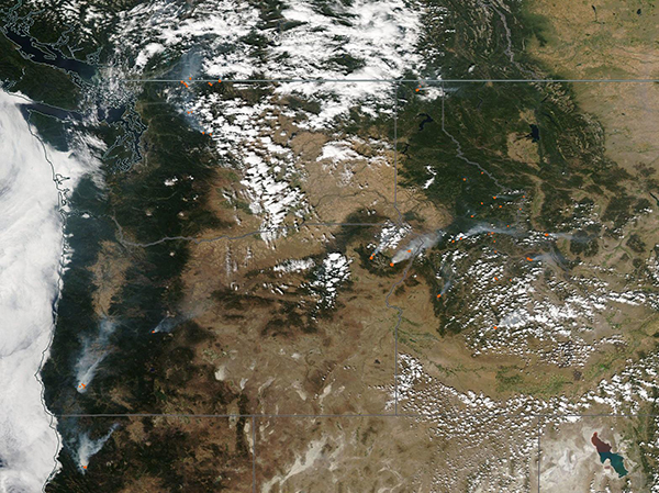
Scorching air temperatures, low humidity, and widespread drought continue to fuel another vicious fire season in the Western United States. With high temperatures expected to be near or over 100˚F (37.8˚C) for the next several days, the National Weather Service (NWS) has advised that much of Idaho will swelter under a Heat Advisory until September 5, 2022. The sizzle also extends to portions of central, north central, and northeast Oregon and central, south central and southeast Washington, where the NWS has raised a Heat Advisory and Red Flag Warning through September 2, with high temperatures expected to hit 105˚F (40.6˚F). Excessive heat warnings span much of California through September 6, especially Southern California, where temperatures may reach 115˚F (46.1˚C).
High air temperatures dry vegetation and help fuel fires. According to the National Interagency Fire Center (NIFC), on September 1 there were 46 large, active fires burning across 5 states: 14 in Idaho, 10 in Montana, 9 in Oregon, 6 in California, 4 in Washington, 1 in Utah, 1 in Arizona, and 1 in Wyoming. These do not include medium or smaller fires, and do count fires being handled as one “complex” fire as only one fire. Five new large fires were reported on August 31 – one each in California, Montana, Oregon, Wyoming, and Washington. These large, active fires were burning on 302,460 acres. None of these fires had been contained.
The NIFC also reports that from January 1, 2022, to September 1, 2022, there had been 48,331 fires across the United States, and these fires had burnt 6,153,171 acres. This is the largest number of fires for the same time period in each of the last 10 years, although only the fifth-largest number of acres destroyed.
On August 31, 2022, the Moderate Resolution Imaging Spectroradiometer (MODIS) on board NASA’s Aqua satellite acquired a true-color image of dozens of fires burning across the American West. The image encompasses part of southern Canada near the U.S. border, as well as all of Oregon and Washington, most of Idaho, western Montana, part of northern California, and northwestern Utah. Each red “hot spot” marks a location that the thermal bands on the MODIS instrument detected high temperatures. When combined with typical smoke, as in this image, such hot spots are diagnostic for actively burning fire. In most areas, thick plumes of smoke blow strongly to the northeast, suggesting windy conditions.
Image Facts
Satellite:
Aqua
Date Acquired: 8/31/2022
Resolutions:
1km (419.9 KB), 500m (1.4 MB), 250m (4.4 MB)
Bands Used: 1,4,3
Image Credit:
MODIS Land Rapid Response Team, NASA GSFC
