
Images


September 3, 2022 - Intensifying Tropical Storm Danielle
 Tweet
Tweet
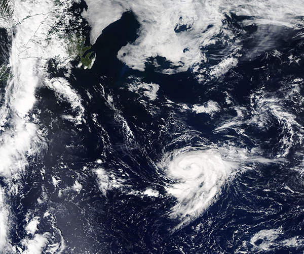
The sleepy 2022 Atlantic hurricane season finally came to a belated start on September 2 when Tropical Storm Danielle’s winds increased to 75 mph (121 km/h), placing it as a Category One hurricane on the Saffir-Simpson Hurricane Wind Scale—and winning the title of the first hurricane to form over the Atlantic in 2022.
The Atlantic hurricane season begins on June 1 to November 30, and encompasses all of the Atlantic basin: the Atlantic Ocean, Caribbean Sea, and Gulf of Mexico. The first tropical storm of 2022 was Alex, which brought copious rain to Southern Florida, U.S.A, and Cuba even before strengthening to tropical storm strength on June 6. The first Atlantic hurricane tends to form in early to mid-August, with major hurricanes tending to form in late August or early September. Two other names storms have formed this year, with Tropical Storm Bonnie in June and Tropical Storm Colin appearing in early July. August passed without a single name storm—for the first time since 1997 and only the second time since 1967.
The National Hurricane Center (NHC) issued its first advisory on the system that would become Danielle at 5:00 a.m. EDT on September 1, stating that a new tropical depression had formed about 975 miles (1,575 km) west of the Azores. At that time maximum sustained winds had reached 35 mph (55 km/h) and the depression was moving east-northeastward. Danielle began to strengthen rapidly, becoming a Tropical Storm at 11:00 a.m. EDT that same day. Twenty-four hours later, at 11:00 a.m. EDT on September 2, the NHC advised that the first hurricane of the Atlantic Season had formed, and its name was Hurricane Danielle. At that time, Danielle was located about 885 miles (1,425 km) west of the Azores and was moving westward at a very slow 1 mph (2 km/h).
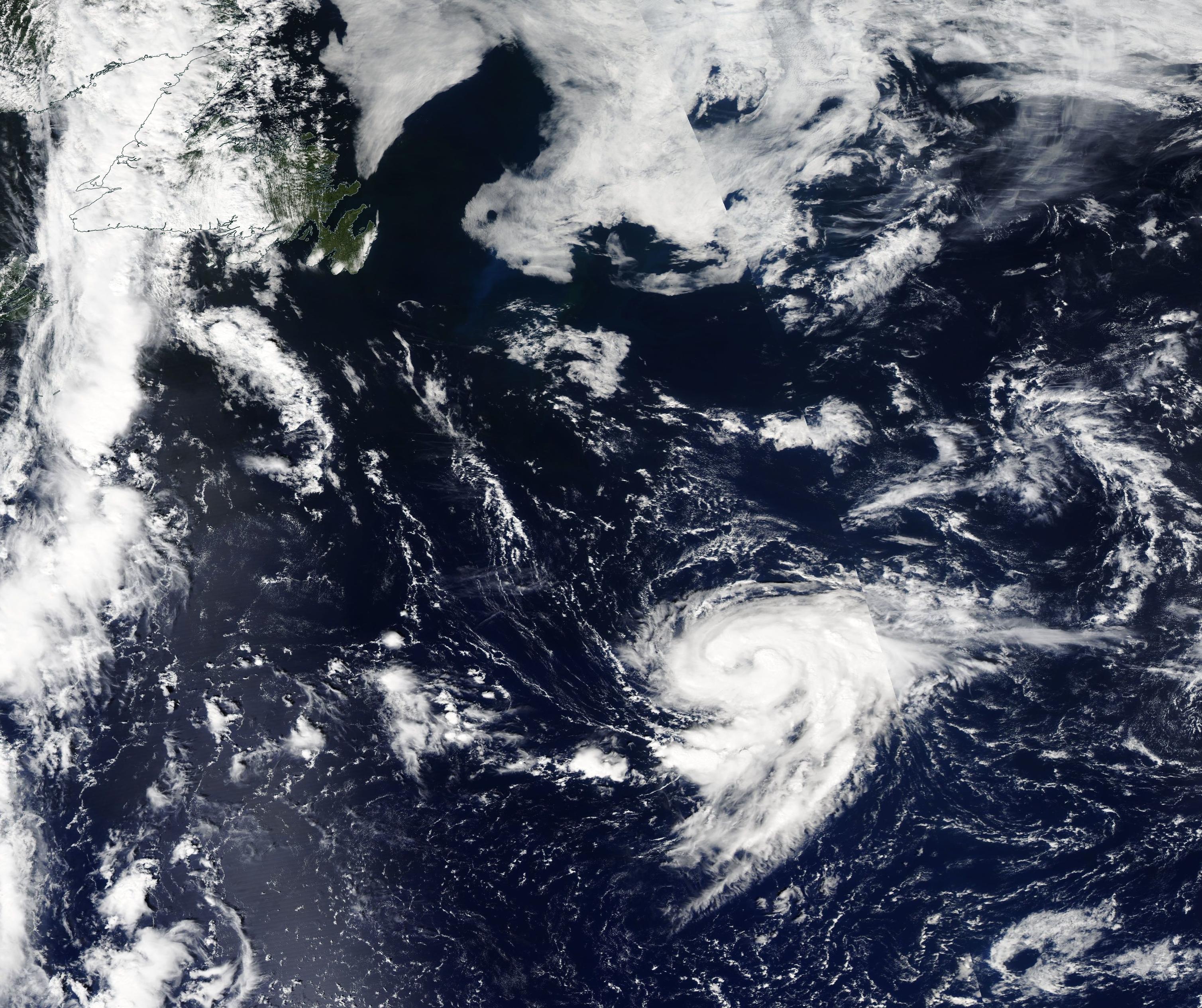
As of the 11:00 p.m. EDT on September 2, the NHC advises that Hurricane Danielle remains stationary over the Atlantic Ocean at about 895 miles (1,445 km) west of the Azores. Maximum sustained winds remain at 75 mph (120 km/h). The storm is expected to “strengthen a little during the next couple of days” as it drifts slowly westward. No coastal warnings are in effect.
The Moderate Resolution Imaging Spectroradiometer (MODIS) on board NASA’s Aqua satellite acquired a true-color image of newly-formed Tropical Storm Danielle as it strengthened over the open Atlantic west of the Azores on September 1. Although Danielle appeared ragged, convective bands could be seen wrapping around a cloud-filled eye, giving the storm the apostrophe-shape that is a common hallmark of strengthening storms.
Image Facts
Satellite:
Aqua
Date Acquired: 9/1/2022
Resolutions:
1km (1.3 MB), 500m (4 MB),
Bands Used: 1,4,3
Image Credit:
MODIS Land Rapid Response Team, NASA GSFC
The sleepy 2022 Atlantic hurricane season finally came to a belated start on September 2 when Tropical Storm Danielle’s winds increased to 75 mph (121 km/h), placing it as a Category One hurricane on the Saffir-Simpson Hurricane Wind Scale—and winning the title of the first hurricane to form over the Atlantic in 2022.
The Atlantic hurricane season begins on June 1 to November 30, and encompasses all of the Atlantic basin: the Atlantic Ocean, Caribbean Sea, and Gulf of Mexico. The first tropical storm of 2022 was Alex, which brought copious rain to Southern Florida, U.S.A, and Cuba even before strengthening to tropical storm strength on June 6. The first Atlantic hurricane tends to form in early to mid-August, with major hurricanes tending to form in late August or early September. Two other names storms have formed this year, with Tropical Storm Bonnie in June and Tropical Storm Colin appearing in early July. August passed without a single name storm—for the first time since 1997 and only the second time since 1967.
The National Hurricane Center (NHC) issued its first advisory on the system that would become Danielle at 5:00 a.m. EDT on September 1, stating that a new tropical depression had formed about 975 miles (1,575 km) west of the Azores. At that time maximum sustained winds had reached 35 mph (55 km/h) and the depression was moving east-northeastward. Danielle began to strengthen rapidly, becoming a Tropical Storm at 11:00 a.m. EDT that same day. Twenty-four hours later, at 11:00 a.m. EDT on September 2, the NHC advised that the first hurricane of the Atlantic Season had formed, and its name was Hurricane Danielle. At that time, Danielle was located about 885 miles (1,425 km) west of the Azores and was moving westward at a very slow 1 mph (2 km/h).
As of the 11:00 p.m. EDT on September 2, the NHC advises that Hurricane Danielle remains stationary over the Atlantic Ocean at about 895 miles (1,445 km) west of the Azores. Maximum sustained winds remain at 75 mph (120 km/h). The storm is expected to “strengthen a little during the next couple of days” as it drifts slowly westward. No coastal warnings are in effect.
The Moderate Resolution Imaging Spectroradiometer (MODIS) on board NASA’s Aqua satellite acquired a true-color image of newly-formed Tropical Storm Danielle as it strengthened over the open Atlantic west of the Azores on September 1. Although Danielle appeared ragged, convective bands could be seen wrapping around a cloud-filled eye, giving the storm the apostrophe-shape that is a common hallmark of strengthening storms.
Image Facts
Satellite:
Aqua
Date Acquired: 9/1/2022
Resolutions:
1km (1.3 MB), 500m (4 MB),
Bands Used: 1,4,3
Image Credit:
MODIS Land Rapid Response Team, NASA GSFC
