
Images


September 7, 2022 - Western United States Wildfires
 Tweet
Tweet
As northern hemisphere summer draws near its end, the Western United States continues to suffer agonizingly high temperatures and widespread wildfire. While California wins the prize for highest temperatures—the National Weather Service reported that Sacramento hit an all-time high of 116˚F on September 6, 2022—the state of Idaho has the most fire activity.
According to the National Interagency Fire Center (NIFC) on September 6, there were 27 large fires burning in that state—up by 13 from September 1. And these are just LARGE fires. A glance at the Idaho Fire Map, published by the state government, shows the state dotted with fire from the border with Canada to the town of Pocatello in the south-eastern section of the state. The largest fire in Idaho is the Moose Fire, which has burned 107,523 acres of grass, brush, and timber north of the town of Salmon. This human-caused fire has been burning more than 7 weeks, and has only reached 44 percent containment.
But ferocious wildfires are hardly contained to Idaho. According to the NIFC, as of September 6, 69 large wildfires and complexes have burned 475,766 acres in eight states. More than 13,000 wildland fire personnel are assigned to incidents. In the West, this includes 27 fires in Idaho, 10 in Montana, 9 in Oregon, 7 in California, 7 in Washington, 2 in Texas, and 1 in Utah. There are also 2 fires in Florida.
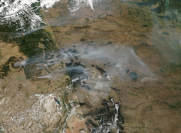
On September 5, 2022, the Moderate Resolution Imaging Spectroradiometer (MODIS) on board NASA’s Aqua satellite acquired a true-color image centered on Idaho. Parts of other states are also visible: Washington and Oregon can be seen west of Idaho, Nevada and Utah to the south, and Montana to the east. Canada sits in the north.
Dozens of red “hot spots” can be seen scattered across the scene, especially in Idaho and western Montana. Each red hot spot marks an area where the thermal bands on the instrument detected high temperatures. When combined with typical smoke, as in this image, such hot spots mark actively burning fire. Smoke pours from many of the large fires, especially those burning in the forests of the Bitterroot Mountains, and blows towards the east. The density and length of the plumes suggest very strong winds blowing from the west.
Dangerous fire weather is expected across most of the Western United States over the next several days. The NIFC advisory states, “Very hot, dry, and unstable conditions will be prevalent across much of the West peaking along thermal trough(s) in California into the Northwest and Great Basin. Widespread temperatures over 100°F are expected, including much of the Central Valley and surrounding foothills above 110°F. Minimum relative humidity will be 3-15% across much of the West and breezy winds are likely to develop in portions of northeast California into southern and central Oregon and in portions of Wyoming. Near record Hot, Dry, Windy Index values are expected across the northern half of California and much of southern and central Oregon as well. Existing and any emerging new fires in these areas will be very active, with increased activity expected on most if not all existing large fires.”
Image Facts
Satellite:
Aqua
Date Acquired: 9/5/2022
Resolutions:
1km (730.4 KB), 500m (2.5 MB),
Bands Used: 1,4,3
Image Credit:
MODIS Land Rapid Response Team, NASA GSFC
As northern hemisphere summer draws near its end, the Western United States continues to suffer agonizingly high temperatures and widespread wildfire. While California wins the prize for highest temperatures—the National Weather Service reported that Sacramento hit an all-time high of 116˚F on September 6, 2022—the state of Idaho has the most fire activity.
According to the National Interagency Fire Center (NIFC) on September 6, there were 27 large fires burning in that state—up by 13 from September 1. And these are just LARGE fires. A glance at the Idaho Fire Map, published by the state government, shows the state dotted with fire from the border with Canada to the town of Pocatello in the south-eastern section of the state. The largest fire in Idaho is the Moose Fire, which has burned 107,523 acres of grass, brush, and timber north of the town of Salmon. This human-caused fire has been burning more than 7 weeks, and has only reached 44 percent containment.
But ferocious wildfires are hardly contained to Idaho. According to the NIFC, as of September 6, 69 large wildfires and complexes have burned 475,766 acres in eight states. More than 13,000 wildland fire personnel are assigned to incidents. In the West, this includes 27 fires in Idaho, 10 in Montana, 9 in Oregon, 7 in California, 7 in Washington, 2 in Texas, and 1 in Utah. There are also 2 fires in Florida.
On September 5, 2022, the Moderate Resolution Imaging Spectroradiometer (MODIS) on board NASA’s Aqua satellite acquired a true-color image centered on Idaho. Parts of other states are also visible: Washington and Oregon can be seen west of Idaho, Nevada and Utah to the south, and Montana to the east. Canada sits in the north. Dozens of red “hot spots” can be seen scattered across the scene, especially in Idaho and western Montana. Each red hot spot marks an area where the thermal bands on the instrument detected high temperatures. When combined with typical smoke, as in this image, such hot spots mark actively burning fire. Smoke pours from many of the large fires, especially those burning in the forests of the Bitterroot Mountains, and blows towards the east. The density and length of the plumes suggest very strong winds blowing from the west.
Dangerous fire weather is expected across most of the Western United States over the next several days. The NIFC advisory states, “Very hot, dry, and unstable conditions will be prevalent across much of the West peaking along thermal trough(s) in California into the Northwest and Great Basin. Widespread temperatures over 100°F are expected, including much of the Central Valley and surrounding foothills above 110°F. Minimum relative humidity will be 3-15% across much of the West and breezy winds are likely to develop in portions of northeast California into southern and central Oregon and in portions of Wyoming. Near record Hot, Dry, Windy Index values are expected across the northern half of California and much of southern and central Oregon as well. Existing and any emerging new fires in these areas will be very active, with increased activity expected on most if not all existing large fires.”
Image Facts
Satellite:
Aqua
Date Acquired: 9/5/2022
Resolutions:
1km (730.4 KB), 500m (2.5 MB),
Bands Used: 1,4,3
Image Credit:
MODIS Land Rapid Response Team, NASA GSFC
