
Images


September 11, 2022 - Tropical Storm Kay Adds to Extreme West Coast Weather
 Tweet
Tweet
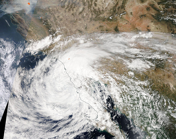
Smoke, fire, extreme heat, a drought-stricken landscape, and winds and rain from a fading hurricane were all on the meteorological menu for Southern California in the opening weeks of September 2022. The prize for the most succinct summary of the situation probably goes to Dr. Daniel Swain, a UCLA climate scientist, who opened this September 7 blog this way, “Let me just start by saying that this is perhaps the singularly most unusual and extreme weather week in quite some time in California–and that is saying something.”
On September 9, the Moderate Resolution Imaging Spectroradiometer (MODIS) on board NASA’s Terra satellite acquired a true-color image that captured a snapshot of some of the extremes affecting Southern California. In this image, smoke pours from the Fairview Fire that is burning southeast of Los Angeles as Tropical Storm Kay approaches, carrying strong gusting winds and heavy rain.
Near the time the image was captured, Kay was carrying maximum sustained winds of bout 45 mph (70 km/h) and was located about 95 mi (155 km) west-northwest of Punta Baja, Mexico and 140 miles (225 km) south of San Diego, California.
The National Hurricane Center (NHC) issued its first advisory on Kay on September 4, when it first noted the formation of a tropical depression about 225 miles (260 km) south-southwest of the town of Acapulco, Mexico. It quickly gathered strength, and by the afternoon of September 5, Kay had become a Category 1 hurricane packing maximum sustained winds of 75 mph (121 km/h) as it moved roughly parallel to the Mexican coast. Two days later, on September 7, Hurricane Kay reached peak strength as a Category 2 hurricane with maximum sustained winds of 105 mph (169 km/h). It then began to weaken shortly before making landfall on the west coast of the central Baja Peninsula, Mexico, on September 8. At landfall, Kay retained a nominal Category 1 status with maximum sustained winds of 75 mph (120 km/h), but it continued a weakening trend as it skirted the northern Baja Peninsula and California coasts.
On the morning of September 10, the NHC issued its last advisory on Kay, which had become a Post-Tropical Cyclone moving to the west-northwest, which was away from the coast and towards the open waters of the Pacific Ocean. At that time maximum sustained winds were 40 mph (64 km/h) with gusts to 52 mph (84 km/h). Kay is forecast to continue to weaken until it dissipates on or about September 14.
The storm brought heavy rainfall to parts of Southern California, including flooding and mudslides to some areas. Gusts ahead of the storm fanned the Fairview Fire, but firefighters had anticipated such an event and fought vigorously. Ultimately, Kay’s rainfall brought cooler temperatures and both higher humidity and some rain to the Fairview Fire, assisting in bringing it to 40 percent containment by late on September 10. The Fairview Fire began on September 5 in the unincorporated county area of Helmet. By the afternoon of September 10, the firefighters and support personnel assigned to the fire had reached 2,241.
Image Facts
Satellite:
Terra
Date Acquired: 9/9/2022
Resolutions:
1km (2.1 MB), 500m (2.4 MB),
Bands Used: 1,4,3
Image Credit:
MODIS Land Rapid Response Team, NASA GSFC
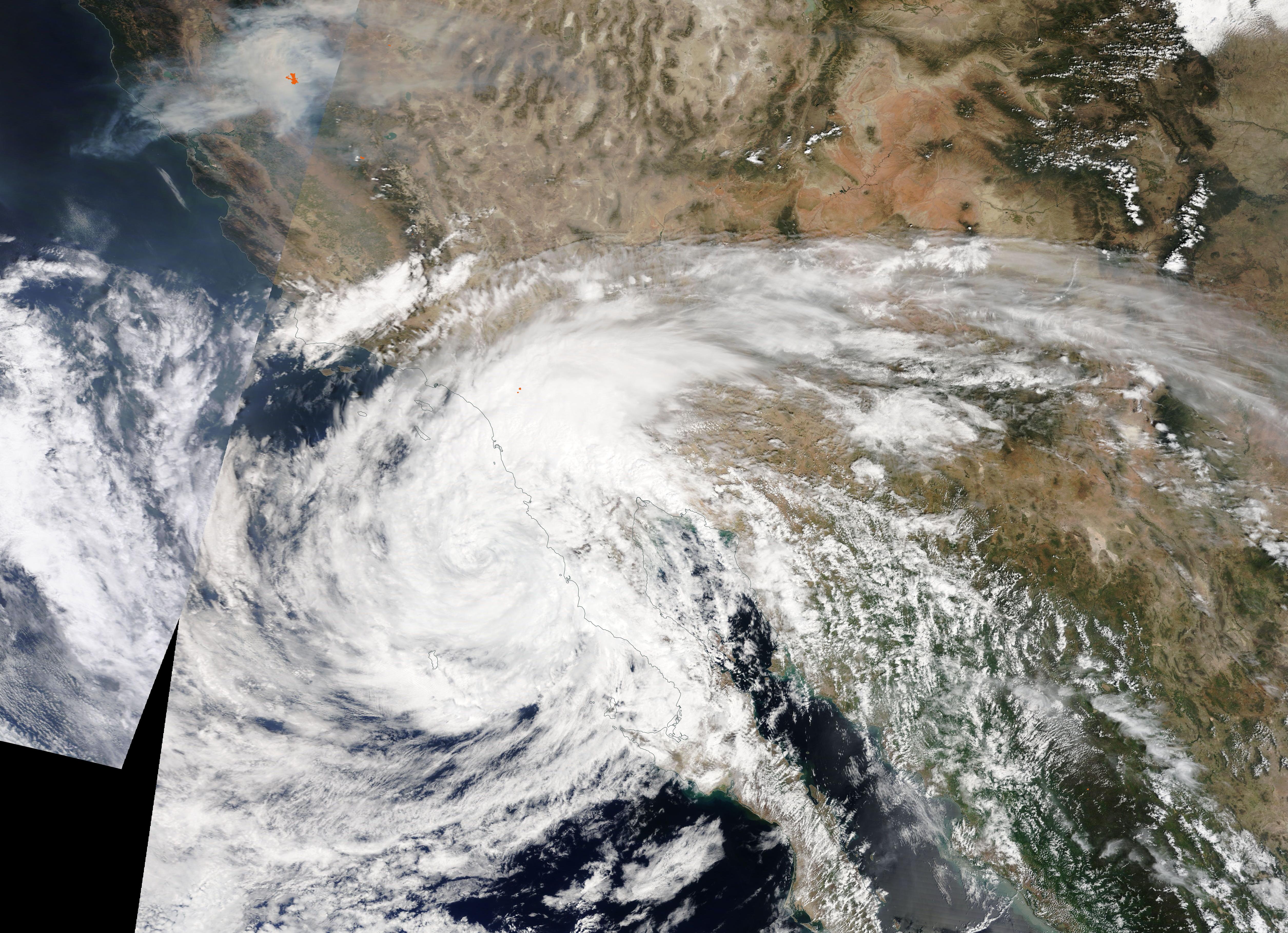
Smoke, fire, extreme heat, a drought-stricken landscape, and winds and rain from a fading hurricane were all on the meteorological menu for Southern California in the opening weeks of September 2022. The prize for the most succinct summary of the situation probably goes to Dr. Daniel Swain, a UCLA climate scientist, who opened this September 7 blog this way, “Let me just start by saying that this is perhaps the singularly most unusual and extreme weather week in quite some time in California–and that is saying something.”
On September 9, the Moderate Resolution Imaging Spectroradiometer (MODIS) on board NASA’s Terra satellite acquired a true-color image that captured a snapshot of some of the extremes affecting Southern California. In this image, smoke pours from the Fairview Fire that is burning southeast of Los Angeles as Tropical Storm Kay approaches, carrying strong gusting winds and heavy rain. Near the time the image was captured, Kay was carrying maximum sustained winds of bout 45 mph (70 km/h) and was located about 95 mi (155 km) west-northwest of Punta Baja, Mexico and 140 miles (225 km) south of San Diego, California.
The National Hurricane Center (NHC) issued its first advisory on Kay on September 4, when it first noted the formation of a tropical depression about 225 miles (260 km) south-southwest of the town of Acapulco, Mexico. It quickly gathered strength, and by the afternoon of September 5, Kay had become a Category 1 hurricane packing maximum sustained winds of 75 mph (121 km/h) as it moved roughly parallel to the Mexican coast. Two days later, on September 7, Hurricane Kay reached peak strength as a Category 2 hurricane with maximum sustained winds of 105 mph (169 km/h). It then began to weaken shortly before making landfall on the west coast of the central Baja Peninsula, Mexico, on September 8. At landfall, Kay retained a nominal Category 1 status with maximum sustained winds of 75 mph (120 km/h), but it continued a weakening trend as it skirted the northern Baja Peninsula and California coasts.
On the morning of September 10, the NHC issued its last advisory on Kay, which had become a Post-Tropical Cyclone moving to the west-northwest, which was away from the coast and towards the open waters of the Pacific Ocean. At that time maximum sustained winds were 40 mph (64 km/h) with gusts to 52 mph (84 km/h). Kay is forecast to continue to weaken until it dissipates on or about September 14.
The storm brought heavy rainfall to parts of Southern California, including flooding and mudslides to some areas. Gusts ahead of the storm fanned the Fairview Fire, but firefighters had anticipated such an event and fought vigorously. Ultimately, Kay’s rainfall brought cooler temperatures and both higher humidity and some rain to the Fairview Fire, assisting in bringing it to 40 percent containment by late on September 10. The Fairview Fire began on September 5 in the unincorporated county area of Helmet. By the afternoon of September 10, the firefighters and support personnel assigned to the fire had reached 2,241.
Image Facts
Satellite:
Terra
Date Acquired: 9/9/2022
Resolutions:
1km (2.1 MB), 500m (2.4 MB),
Bands Used: 1,4,3
Image Credit:
MODIS Land Rapid Response Team, NASA GSFC
