
Images


September 15, 2022 - The Shrinking Coastline of the Caspian Sea
 Tweet
Tweet
Measured by surface area, the Caspian Sea is the Earth’s largest inland water body, spanning about 143,200 square miles (371,000 square kilometers). Measured by economic, social, and biodiversity standards, it is priceless. The Caspian contains a rich oil and gas reserve, an important fishery, resources for agriculture, provides for recreation and work for large population living nearby, and contains many important and sensitive species—for example, it contains an estimated 90 percent of the last sturgeon left in the world.
Every square inch of the Caspian Sea holds ecological treasure, but the northern section holds a particularly important and sensitive ecosystem. Here, the shallow waters teem with mollusks, crustaceans, fish, and birds. Seals raise their pups on winter ice that usually only forms in this part of the lake. All rely on a healthy water level for their existence. However, the Caspian Sea is rapidly shrinking.
Radar altimetry data collected by multiple satellites and compiled by NASA's Global Water Monitor indicate that the Caspian's water levels have been dropping since the mid-1990s. As climate change causes increased air temperature, evaporation will increase—and will be a primary driver of loss of water from the Caspian Sea. In a paper published in 2019, it was estimated that Caspian water levels could drop by 9 to 18 meters (30 to 59 feet) by the end of the 21st century, enough that it would lose about a quarter of its area and uncover about 93,000 square kilometers (36,000 square miles) of dry land. That is an area about as large as Portugal.
In a newer paper, published in 2021, scientists ran several different models to estimate water loss in the Caspian Sea due to climate change, which gave estimates of loss by the year 2100 as low as 8 meters (36 ft) and as high as 30 meters (98 ft). Because extraction (human use or diversion of water) is also an important driver of water loss in the Caspian, the scientists also estimated this factor—something overlooked in most other estimates. They found that water extraction would add up to 7 meters (23 feet) further loss. While the deepest parts of the Caspian plunge to more than 1,000 meters below sea level, the northern portion has an average depth of only 5-6 meters. All but one of the models in this study showed complete desiccation of the northern section of the Caspian by the end of the 21st century.
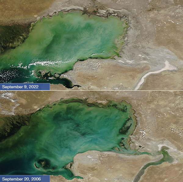
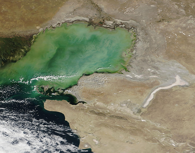
On September 6, 2022, the Moderate Resolution Imaging Spectroradiometer (MODIS) on the Terra satellite acquired a true-color image of the northeastern section of the Caspian Sea. The sprawling, green Volga River Delta can be seen along the northern coast at the left (west) edge of the image. Swirls of green and tan color the shallow water, created by the sediment carried in by the fresh water of the Volga and by currents that stir up sediment from the shallow sea floor in this region. A broad area of the coastlines near the waters are tinted light gray. In addition, patches of bright white along with a large swath of white color the landscape southeast of the Caspian. These light colors are salt and other minerals left behind after evaporation.
For our Image of the Day, we have compared the September 6, 2022 image with a true-color image acquired by the MODIS instrument on Terra on September 20, 2006. In this image, there is no light-colored, salt-laden halo along the northern shore and only a relatively small “salt-shadow” in the east and south. Water fills the serpentine area that, twelve years later, has become a thick mineral crust.
While this Image of the Day gives a striking comparison illustrating the shrinking shoreline of the Caspian Sea, it is even easier to visualize the change with a roll-over comparison. Thanks to the NASA Worldview App, this can be easily visualized simply by clicking here. Using the measurement tool in the lower left corner of the roll-over comparison on Worldview, it appears that the eastern coastline has receded approximately 17.5 feet (5.3 meters) in the last twelve years.
Image Facts
Satellite:
Terra
Date Acquired: 9/11/2022
Resolutions:
1km (319.8 KB), 500m (788.6 KB), 250m (513.9 KB)
Bands Used: 1,4,3
Image Credit:
MODIS Land Rapid Response Team, NASA GSFC
Measured by surface area, the Caspian Sea is the Earth’s largest inland water body, spanning about 143,200 square miles (371,000 square kilometers). Measured by economic, social, and biodiversity standards, it is priceless. The Caspian contains a rich oil and gas reserve, an important fishery, resources for agriculture, provides for recreation and work for large population living nearby, and contains many important and sensitive species—for example, it contains an estimated 90 percent of the last sturgeon left in the world.
Every square inch of the Caspian Sea holds ecological treasure, but the northern section holds a particularly important and sensitive ecosystem. Here, the shallow waters teem with mollusks, crustaceans, fish, and birds. Seals raise their pups on winter ice that usually only forms in this part of the lake. All rely on a healthy water level for their existence. However, the Caspian Sea is rapidly shrinking.
Radar altimetry data collected by multiple satellites and compiled by NASA's Global Water Monitor indicate that the Caspian's water levels have been dropping since the mid-1990s. As climate change causes increased air temperature, evaporation will increase—and will be a primary driver of loss of water from the Caspian Sea. In a paper published in 2019, it was estimated that Caspian water levels could drop by 9 to 18 meters (30 to 59 feet) by the end of the 21st century, enough that it would lose about a quarter of its area and uncover about 93,000 square kilometers (36,000 square miles) of dry land. That is an area about as large as Portugal.
In a newer paper, published in 2021, scientists ran several different models to estimate water loss in the Caspian Sea due to climate change, which gave estimates of loss by the year 2100 as low as 8 meters (36 ft) and as high as 30 meters (98 ft). Because extraction (human use or diversion of water) is also an important driver of water loss in the Caspian, the scientists also estimated this factor—something overlooked in most other estimates. They found that water extraction would add up to 7 meters (23 feet) further loss. While the deepest parts of the Caspian plunge to more than 1,000 meters below sea level, the northern portion has an average depth of only 5-6 meters. All but one of the models in this study showed complete desiccation of the northern section of the Caspian by the end of the 21st century.
On September 6, 2022, the Moderate Resolution Imaging Spectroradiometer (MODIS) on the Terra satellite acquired a true-color image of the northeastern section of the Caspian Sea. The sprawling, green Volga River Delta can be seen along the northern coast at the left (west) edge of the image. Swirls of green and tan color the shallow water, created by the sediment carried in by the fresh water of the Volga and by currents that stir up sediment from the shallow sea floor in this region. A broad area of the coastlines near the waters are tinted light gray. In addition, patches of bright white along with a large swath of white color the landscape southeast of the Caspian. These light colors are salt and other minerals left behind after evaporation.
For our Image of the Day, we have compared the September 6, 2022 image with a true-color image acquired by the MODIS instrument on Terra on September 20, 2006. In this image, there is no light-colored, salt-laden halo along the northern shore and only a relatively small “salt-shadow” in the east and south. Water fills the serpentine area that, twelve years later, has become a thick mineral crust.
While this Image of the Day gives a striking comparison illustrating the shrinking shoreline of the Caspian Sea, it is even easier to visualize the change with a roll-over comparison. Thanks to the NASA Worldview App, this can be easily visualized simply by clicking here. Using the measurement tool in the lower left corner of the roll-over comparison on Worldview, it appears that the eastern coastline has receded approximately 17.5 feet (5.3 meters) in the last twelve years.
Image Facts
Satellite:
Terra
Date Acquired: 9/11/2022
Resolutions:
1km (319.8 KB), 500m (788.6 KB), 250m (513.9 KB)
Bands Used: 1,4,3
Image Credit:
MODIS Land Rapid Response Team, NASA GSFC
