
Images


September 17, 2022 - Super Typhoon Nanmadol Threatens Japan
 Tweet
Tweet
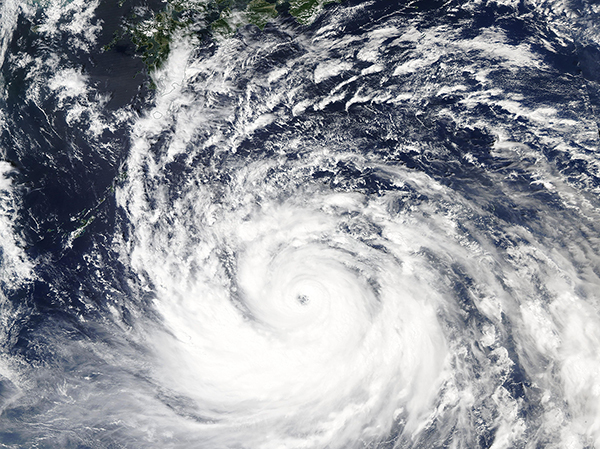
Super Typhoon Nanmadol reached peak strength on September 16, 2022, as it headed towards a potentially devastating landfall over Japan. The Moderate Resolution Imaging Spectroradiometer (MODIS) on board NASA’s Aqua satellite acquired a true-color image of the storm on that same day.
According to the Joint Typhoon Warning Center (JTWC), at 5:00 p.m. EDT (2100 UTC) on September 16 Nanmadol’s maximum sustained winds reached 155 mph (249.5 km/h) with gusts up to 190 mph (306 km/h). That places it as a strong Category 4 storm on the Saffir-Simpson Hurricane Wind Scale. At that time, the Super Typhoon was located about 379 miles (610 km) east of Kadena Air Base, Okinawa, Japan and was traveling northwestward. Maximum significant wave height was estimated at 52 feet.
Since that time, Super Typhoon Nanmadol (also known as Josie in the Philippines) has begun to weaken as it continues on a track to impact Japan. At 11:00 p.m. EDT September 16 (0300 UTC on September 17), the JTWC advised that maximum sustained winds were at 150 mph (241 km/h) with gusts to 184 mph (296 km/h), which is still falls within Category 4. At that time, Nanmadol was located 330 miles (531 km) east of Kadena Air Base and was continuing to track northwestward.
Super Typhoon Nanmadol is expected to continue to weaken slightly through September 17, although it is still expected to remain a Category 4 storm carrying maximum sustained winds of 138 mph (222 km/h) by the end of that day. It should be at or near this strength as it passes just southwest of Yaku Shima Island on September 18. It is forecast to make a sharp turn to the northeast, which will accelerate weaking before making landfall in the vicinity of Nagasaki by September 19. It will then accelerate quickly to the northeast, which may carry it over mainland Japan. The maximum sustained wind near landfall is forecast at about 104 mph (167 km/h), which places it as a Category 2 storm.
According to the Global Disaster Alert and Coordination System (GDACS), 34.8 million people may be impacted by Category 1 winds or higher. Most of these will be in the Kagoshima prefecture, which is located on the southern tip of Kyushu Island and includes several nearby islands. A report by The Japan Times states that the Japan Meteorological Agency has forecast only slight weakening before landfall, which would bring it onshore at a high windspeed than currently predicted by JTWC. The report also said that “The agency warned of high waters, storm surges, landslides, flooding and overflowing rivers. It said the wind could be so strong in areas like southern Kyushu that some homes would be a risk of collapse, urging residents to stay in sturdy building and stay away from windows.”
Image Facts
Satellite:
Aqua
Date Acquired: 9/16/2022
Resolutions:
1km (2.9 MB), 500m (2.4 MB),
Bands Used: 1,4,3
Image Credit:
MODIS Land Rapid Response Team, NASA GSFC
