
Images


September 21, 2022 - Storm-driven Sediment in the Yellow Sea
 Tweet
Tweet
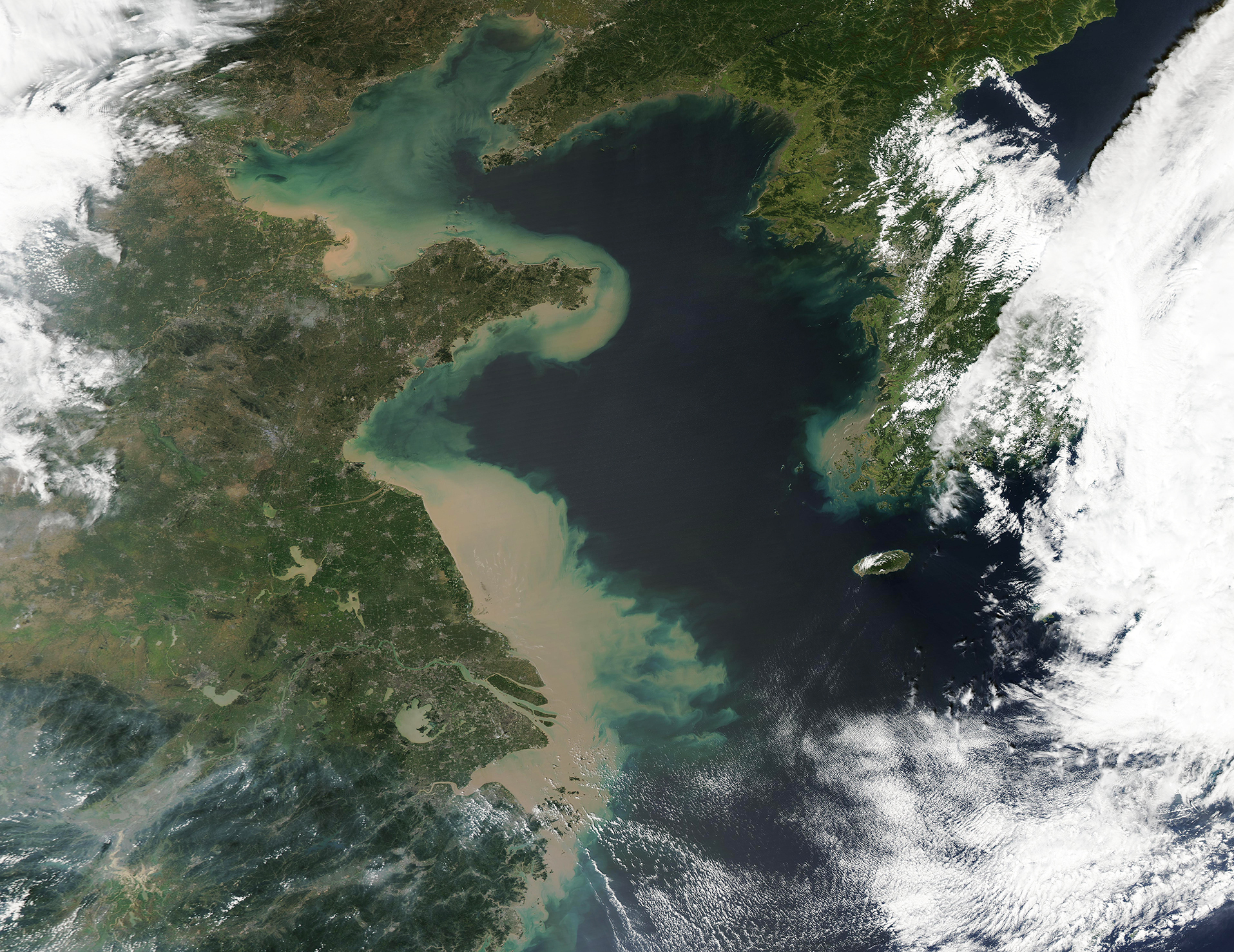
On September 14, 2022, Typhoon Muifa made landfall twice near China’s largest metropolitan area and several of the world’s major shipping ports. The typhoon first crossed over land at Zhoushan Island, then passed over Hangzhou Bay, and eventually came ashore in Shanghai. On September 15 the typhoon barreled over the Yellow Sea, crossed Shantung Peninsula, darted across the northern Yellow Sea, to make a fourth landfall on the Liaodong Peninsula before moving into the interior of Northeast China early on September 16, where it rapidly weakened to a very wet tropical depression.
The storm’s maximum sustained winds as it made first landfall over Zhoushan were estimated just above 90 mph (145 km/h), which placed it as a strong Category 1 storm on the Saffir-Simpson Hurricane Wind Scale. Typhoon Muifa weakened slightly, although maintained Category 1 strength, as it made the second landfall in Shanghai. At that time, maximum sustained winds were near 80 mph (129 km/h).
News reports called Typhoon Muifa the strongest storm to reach the Yangtze River Delta since Typhoon Damrey in 2012. An estimated 230 million people live on and around the delta. Operations were suspended in the major ports of Ningbo and Shanghai, as well as oil and gas operations on Zhoushan. Ferry and shipping traffic were suspended, fishing boats were called into port, and flights to and from the region were canceled. According to China’s Xinhua news agency, more than 1.3 million people were relocated from Zhoushan before the arrival of the storm.
Reports of damage following Typhoon Muifa’s trek across China are sparse, but the storm left tell-tale marks of its passage that can easily be seen from space. On September 19, 2022, the Moderate Resolution Imaging Spectroradiometer (MODIS) on board NASA’s Terra satellite acquired a true-color image showing dense sediment in the Yellow Sea, undoubtedly the aftermath of heavy rain and wind.
On September 17, the first day the storm clouds cleared, MODIS satellite imagery revealed a small amount sediment in the coastal waters of the Yellow Sea, especially over Subei Shoals. This is a shallow area of tidal sand ridges, where sediment is easily stirred by wind, currents, or tides and it often appears tan in satellite images. By September 18, the waters along the coast from the Shandong Peninsula south carried an increasing amount of light tan sediment. By September 19, thick mud-colored sediment filled near-shore waters from the Bohai Sea to well south of Shanghai, as shown in this image. Sediment also can be seen filling the Yangtze River, which appeared to be flooded and muddy well inland.
Given the increasing sediment load between September 17 and September 19, it is almost certain that most of the sediment had been carried into the Yellow Sea from storm waters filling the rivers and pouring into the Sea, rather than from the direct effect of winds and waves.
Image Facts
Satellite:
Aqua
Date Acquired: 9/19/2022
Resolutions:
1km (2.4 MB), 500m (6.7 MB), 250m (15.8 MB)
Bands Used:
Image Credit:
MODIS Land Rapid Response Team, NASA GSFC
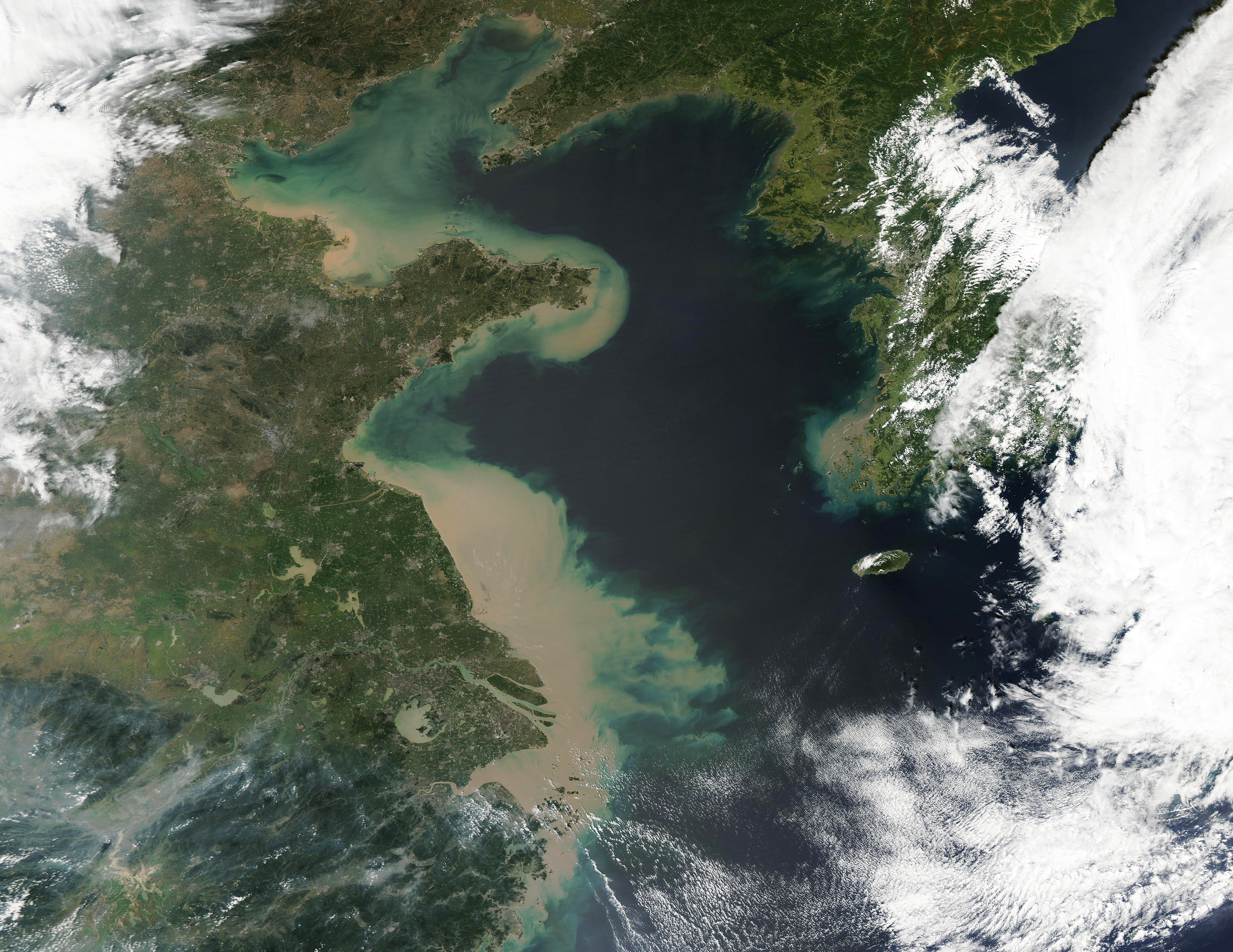
