
Images


September 23, 2022 - Pakistan Floods
 Tweet
Tweet
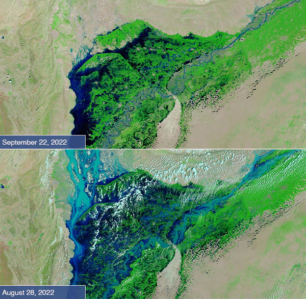
Today’s Image of the Day compares two false-color images of the Indus River and adjacent floodplain in the Sindh province of Pakistan that were acquired by the Moderate Resolution Imaging Spectroradiometer (MODIS) on NASA’s Terra satellite. The top image was acquired on September 22, 2022, and the bottom image on August 28.
Extreme flooding is obvious in both images, but the comparison shows that some—but far from all—of the recent disastrous flooding has begun to recede. According to the United Nations (UN), on September 20 millions of people in Pakistan are still deeply affected by catastrophic flooding, which “is not going anywhere”. It is expected to take six months for the waters to fully recede.
It is estimated that nearly eight million people have been displaced by monsoonal flooding in Pakistan, which began as early as June. To date, more than 1,500 people have been killed, including 552 children, according to the UN. As often happens after disasters, illness and disease have begun to spread through displaced communities, including cerebral malaria, the most severe form of the disease which is often fatal. Malaria is caused by a parasite that is carried by mosquitoes, which thrive in standing waters after flooding.
This type of false-color image uses infrared and visible light (MODIS bands 7,2,1) to help distinguish water from land. Water appears various shades of blue, depending on depth and any sediment in the water, with the deepest water looking the darkest. Vegetation looks bright green while open or sparsely vegetated land looks tan. Cloud ranges from white to electric blue.
Image Facts
Satellite:
Terra
Date Acquired: 9/22/2022
Resolutions:
1km (223.7 KB), 500m (574.7 KB), 250m (333.1 KB)
Bands Used: 1,4,3
Image Credit:
MODIS Land Rapid Response Team, NASA GSFC
