
Images


September 24, 2022 - Hurricane Fiona
 Tweet
Tweet
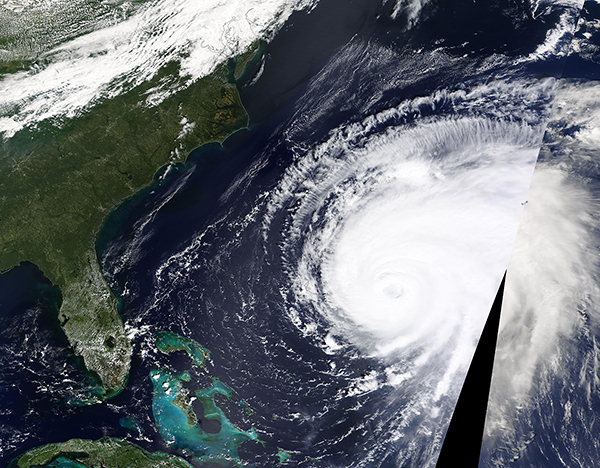
On September 22, 2022, the Moderate Resolution Imaging Spectroradiometer (MODIS) on board NASA’s Terra satellite acquired a true-color image of Hurricane Fiona spinning over the Atlantic Ocean at peak strength as a Category 4 storm. Near the time that the image was acquired, Fiona carried maximum sustained winds of 130 mph (209 km/h) and was located about 345 miles (555 km) west-southwest of Bermuda. Rain and gusty winds were already reaching Bermuda, which can be seen as a small outlined area in the clouds near the line where two swaths of data have been joined.
On September 23, Tropical Cyclone Fiona weakened slightly as it passed about 125 miles (201 km) west-northwest of Bermuda carrying maximum sustained winds of 125 mph (201 km/h). Bermuda suffered widespread power outages brought as hurricane-force gusts and sustained winds of up to 70 mph (112.6 km/h) battered that country.
The storm is heading towards Canada, where it is expected to make landfall over Nova Scotia as a strong extra-tropical storm. As of 11:00 p.m. EDT on September 23, the National Hurricane Center (NHC) advised that strong winds and heavy rains were spreading over Nova Scotia, while the center of Fiona was located about 140 miles (220 km) east of Halifax. The storm’s maximum sustained winds were 105 mph (165 km/h), which is Category 2. The Canadian Hurricane Centre has warned that Fiona could be “a historic, extreme event”, bringing power outages and coastal flooding to the region.
Image Facts
Satellite:
Date Acquired: 9/22/2022
Resolutions:
Bands Used:
Image Credit:
MODIS Land Rapid Response Team, NASA GSFC
