
Images


September 28, 2022 - Hurricane Ian Takes Aim at Florida
 Tweet
Tweet
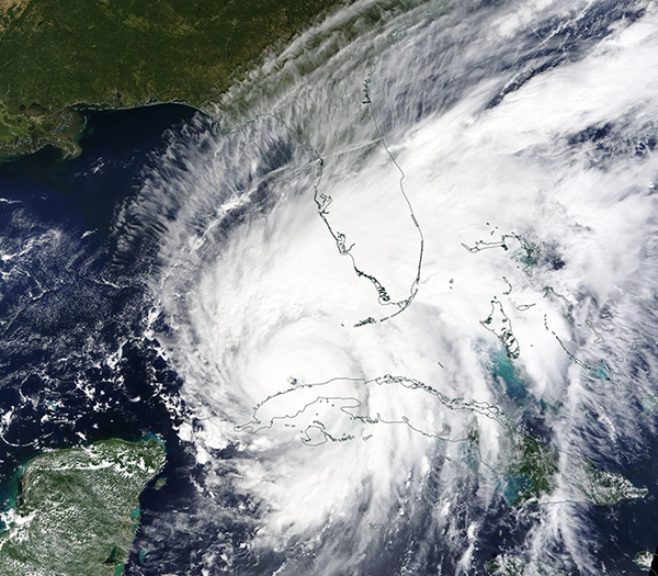
On September 27, 2022, Hurricane Ian battered Cuba as a major hurricane, then strengthened over the warm waters of Gulf of Mexico as it took aim at the U.S. state of Florida.
The Moderate Resolution Imaging Spectroradiometer (MODIS) on board NASA’s Terra satellite acquired a true-color image of Ian shortly after the storm's large, cloud-free center moved off of Cuba on that same day. Rain bands associated with the northeast quadrant of the storm stretched more than 600 miles (965 km) to cover much of Florida and The Bahamas. Near the same time, the National Hurricane Center (NHC) advised that Ian was located about 305 miles (490 km) south-southwest of Sarasota, Florida and about 125 miles (200 km) south-southwest of the Dry Tortugas. It was carrying maximum sustained winds of 115 mph (185 km/h) and was traveling north at 10 mph (17 km/h).
When Hurricane Ian made landfall in Pinar Del Río province, Cuba at 4:30 a.m. EDT (0830 UTC) on September 27, it carried maximum sustained winds of 125 mph (201 km/h), which is a Category 3 (major) hurricane. Early damage assessments state that the westernmost province of Cuba bore the brunt of Ian’s wrath, with significant damage reported across the province. ReliefWeb reports that, as of September 27, two people have died. News sources report that the entire power grid in Cuba has failed, leaving the country in the dark in Ian’s wake.
At 7:30 p.m. EDT on September 27, with strengthening Hurricane Ian’s center still 180 miles (290 km) south-southwest of Punta Gorda, Florida, tornadoes spawned on the northeast leading edge of the storm. The Miami Herald reported that two tornadoes were confirmed by the National Weather Service, and that the North Perry Airport suffered extensive damage, with multiple small aircraft flipped over. Local media reported that, by 9:33 p.m. EDT, over 25,000 customers in Florida have already lost power.
At 11:00 p.m. EDT on September 27 (0300 UTC September 28), the NHC stated, “Ian expected to cause life-threatening storm surge, catastrophic winds and flooding in the Florida Peninsula”. At that time, Hurricane Ian was located at 24.9N 82.9W, or about 110 miles (175 km) southwest of Naples, Florida. It was carrying maximum sustained winds of 120 mph (195 km/h), which places it as a strong Category 3 hurricane. Ian was moving north-northeast at 10 mph (17 km/h). The track of the storm has shifted slightly eastward during this advisory, which may bring it ashore near Fort Myers, likely as a Category 4 storm carrying maximum sustained winds of 130 mph (209 km/h).
Once on land, Ian is expected to begin to weaken rapidly while still carrying torrential rains. It is forecast to cross over the Florida Peninsula, exiting over the Atlantic Ocean near Daytona Beach at tropical storm strength on September 29, before recurving to make a third landfall in Georgia by September 30.
Image Facts
Satellite:
Terra
Date Acquired: 9/27/2022
Resolutions:
1km (546.8 KB), 500m (1.7 MB), 250m (5.1 MB)
Bands Used: 1,4,3
Image Credit:
MODIS Land Rapid Response Team, NASA GSFC
