
Images


October 7, 2022 - Fires and Smoke in Africa
 Tweet
Tweet
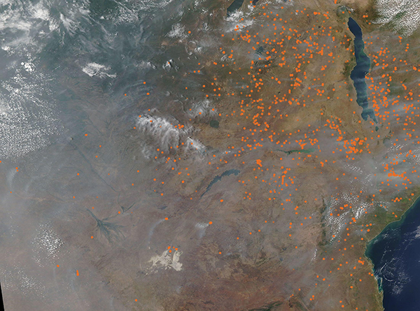
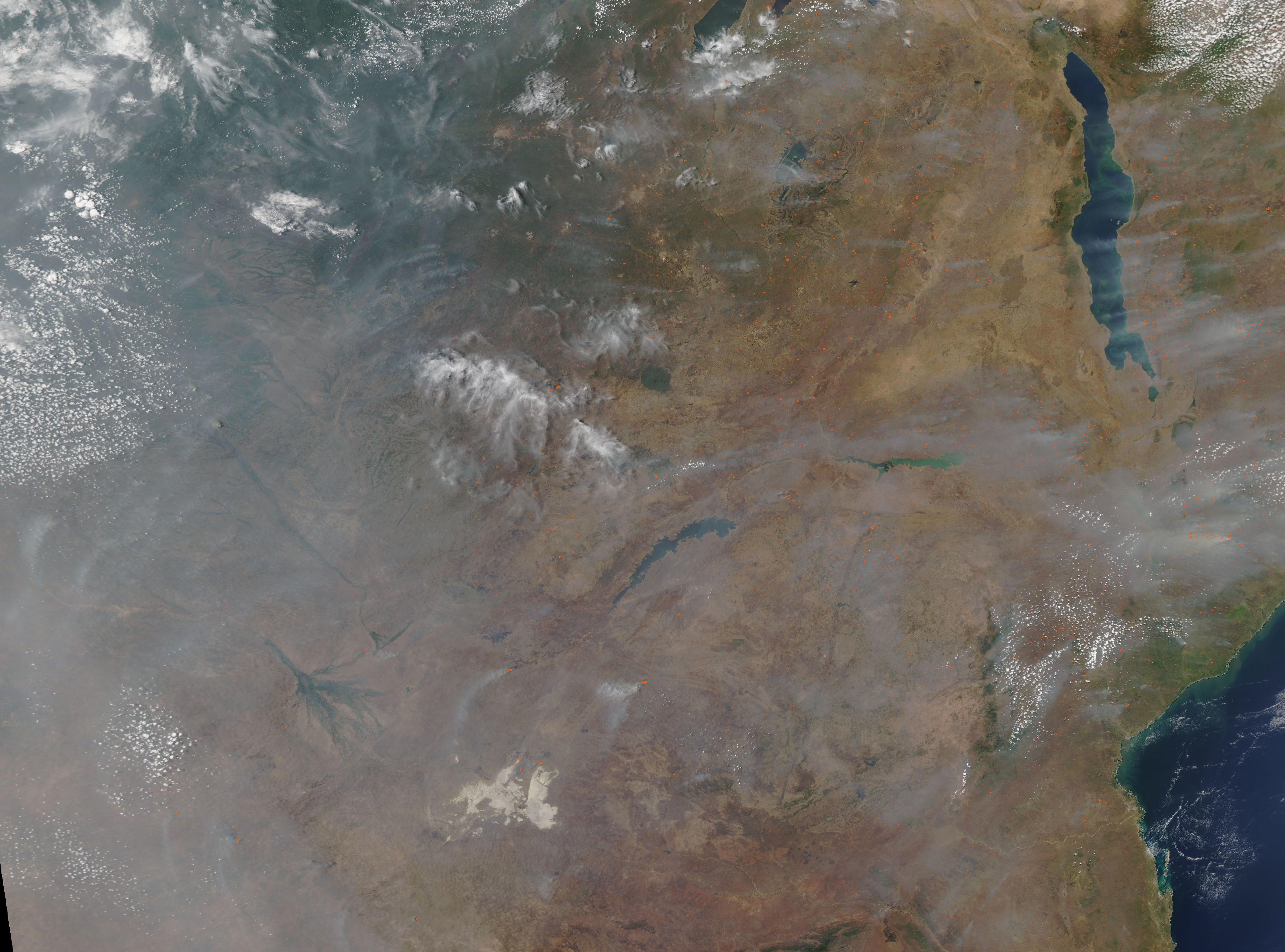
Many hundreds of late-dry-season fires speckled the landscape of Southeast Africa and created a thick shroud of smoke in early October 2022. The Moderate Resolution Imaging Spectroradiometer (MODIS) on board NASA’s Aqua satellite acquired a true-color image of the fiery scene on October 6.
While it is not possible to discern, for certain, the cause of any individual fire through satellite imagery, the location and number of the fires, along with the time of year, strongly suggest these are agricultural fires.
Traditional peoples in many cultures across the Earth have deliberately set and managed fire as an aide in croplands and pasture for hundreds—likely thousands—of years. Farmers set fires to clear stubble from old crops and fertilize soil for new plantings, to renew grazing land, to deal with trash, to remove brush, and to open new land for farming purposes. In Southeast Africa, the dry season, which runs from May to October, coincides with the fire season, although most fires occur in September through October.
Each red “hot spot” in this image marks an area where the thermal bands on the MODIS instrument detected high temperatures. When combined with typical smoke, as in this image, such hot spots are diagnostic for actively burning fire.
The majority of the clusters of fires are found in a broad circle around Lake Malawi. Abundant fires are found in the following countries, beginning in the north and moving clockwise around Lake Malawi, which is the largest lake in the image: Tanzania, Mozambique, Zambia, and—in the center of all of these countries and containing most of the lake, the country of Malawi. Zimbabwe, located south of Zambia and Mozambique, also contains dozens of fires.
Heavy smoke stretches westward to reach the South Atlantic Ocean. This single image does not capture the entire swath of choking smoke, nor all the fires that are partially hidden under the gray pall. However, the NASA Worldview app permits a wider look at the entire width of Africa—and all the smoke and active fires occurring in this dry season. The see the larger view, simply click
here.
The NASA Worldview app provides a satellite's perspective of the planet as it looks today and as it has in the past through daily satellite images. Worldview is part of NASA’s Earth Observing System Data and Information System. EOSDIS makes the agency's large repository of data accessible and freely available to the public.
'
Image Facts
Satellite:
Aqua
Date Acquired: 10/6/2022
Resolutions:
1km (400.6 KB), 500m (1.3 MB),
Bands Used: 1,4,3
Image Credit:
MODIS Land Rapid Response Team, NASA GSFC
Many hundreds of late-dry-season fires speckled the landscape of Southeast Africa and created a thick shroud of smoke in early October 2022. The Moderate Resolution Imaging Spectroradiometer (MODIS) on board NASA’s Aqua satellite acquired a true-color image of the fiery scene on October 6.
While it is not possible to discern, for certain, the cause of any individual fire through satellite imagery, the location and number of the fires, along with the time of year, strongly suggest these are agricultural fires.
Traditional peoples in many cultures across the Earth have deliberately set and managed fire as an aide in croplands and pasture for hundreds—likely thousands—of years. Farmers set fires to clear stubble from old crops and fertilize soil for new plantings, to renew grazing land, to deal with trash, to remove brush, and to open new land for farming purposes. In Southeast Africa, the dry season, which runs from May to October, coincides with the fire season, although most fires occur in September through October.
Each red “hot spot” in this image marks an area where the thermal bands on the MODIS instrument detected high temperatures. When combined with typical smoke, as in this image, such hot spots are diagnostic for actively burning fire.
The majority of the clusters of fires are found in a broad circle around Lake Malawi. Abundant fires are found in the following countries, beginning in the north and moving clockwise around Lake Malawi, which is the largest lake in the image: Tanzania, Mozambique, Zambia, and—in the center of all of these countries and containing most of the lake, the country of Malawi. Zimbabwe, located south of Zambia and Mozambique, also contains dozens of fires.
Heavy smoke stretches westward to reach the South Atlantic Ocean. This single image does not capture the entire swath of choking smoke, nor all the fires that are partially hidden under the gray pall. However, the NASA Worldview app permits a wider look at the entire width of Africa—and all the smoke and active fires occurring in this dry season. The see the larger view, simply click here.
The NASA Worldview app provides a satellite's perspective of the planet as it looks today and as it has in the past through daily satellite images. Worldview is part of NASA’s Earth Observing System Data and Information System. EOSDIS makes the agency's large repository of data accessible and freely available to the public.
'
Image Facts
Satellite:
Aqua
Date Acquired: 10/6/2022
Resolutions:
1km (400.6 KB), 500m (1.3 MB),
Bands Used: 1,4,3
Image Credit:
MODIS Land Rapid Response Team, NASA GSFC
