
Images


November 1, 2022 - Inland Niger Delta at the End of the Rainy Season
 Tweet
Tweet
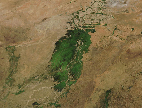
On October 31, 2022, the Moderate Resolution Imaging Spectroradiometer (MODIS) on board NASA’s Aqua satellite acquired a true-color image of central Mali, showing the Inland Niger Delta wetlands flush with vegetation after a long and wet rainy season. Each year, this emerald-colored jewel fills with floodwaters from the Niger River, the Bani River, and a network of smaller streams during the wet season (July through October), growing to about 7,700 square miles (20,000 square kilometers). As rains cease and the dry season progresses, rising temperatures speed evaporation to shrink this inland delta to about 1,500 square miles (3,900 square miles).
In typical years, the inundated delta attracts a wide array of animals and birds to the freshened wetlands, while the waters help fertilize soils and aid farming efforts in the region. Unfortunately, 2022 was not a typical year in the Central Sahel. According to the United Nations High Commissioner for Refugees (UNHCR), in the countries of the Central Sahel (Niger, Mali, and Burkina Faso), above-average rains and floodings brought disaster to residents, and “have killed hundreds, displaced thousands, and decimated over one million hectares of cropland.” They estimate that more than 41,000 people have been affected by the excess flooding throughout Mali. In 2021, damaging flooding affected 10,511 people in the same region.
The true-color image, above, effectively shows a snapshot of Mali on a single overpass on a single day. Sometimes, especially with cyclical changes that affect a region, much more information can be gleaned from looking at changes over time. The NASA Worldview app makes comparisons quick and easy. To view a roll-over comparison of two Aqua MODIS images of this same region simply click here . The first image is our Image of the Day collected on October 31, 2022, at the end of the wet season. The other was acquired on June 2, 2022, at the end of the dry season and before rains began. The difference is dramatic.
The NASA Worldview app provides a satellite's perspective of the planet as it looks today and as it has in the past through daily satellite images. Worldview is part of NASA’s Earth Observing System Data and Information System. EOSDIS makes the agency's large repository of data accessible and freely available to the public.
Image Facts
Satellite:
Aqua
Date Acquired: 10/31/2022
Resolutions:
1km (177.5 KB), 500m (494.7 KB), 250m (318.8 KB)
Bands Used: 1,4,3
Image Credit:
MODIS Land Rapid Response Team, NASA GSFC
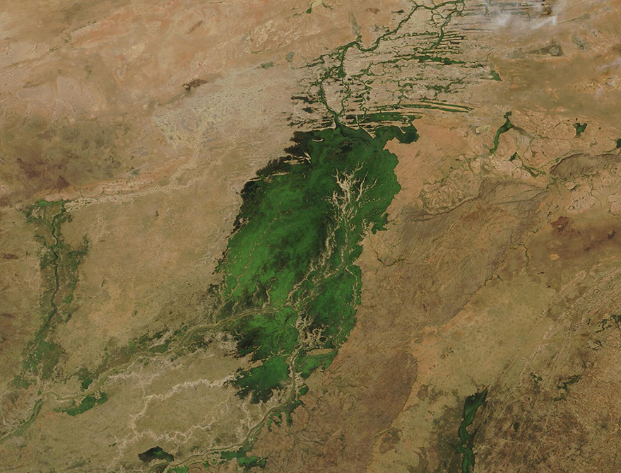
