
Images


January 22, 2023 - Snow in the Western United States
 Tweet
Tweet
On January 19, 2023, after weathering several series of winter storms in the past two months, a local Denver, Colorado news company’s headline read, “Say it ain’t snow!”. But it was snow—and plenty of it. From January 17-18, the storm brought white-out conditions to Denver for several hours while 9.1 inches of new snow accumulated at Denver International Airport. That brings this storm to eighth place in Denver’s Top 10 two-day total accumulation for the month of January.
The best description of the event comes from the National Weather Service (NWS), which wrote, “An area of low pressure developed along the lee of the Rockies in eastern Colorado and tracked northeast across the Great Plains…Plentiful moisture and powerful dynamics of a system more typical of a springtime storm came together to result in a swath of significant snowfall.” The heaviest-hit area was western and north central Nebraska, where the single calendar day snowfall record was broken at North Platte, with a total of 13.9 inches of accumulation at that location. Two feet of snow were also recorded in Custer County, Nebraska.
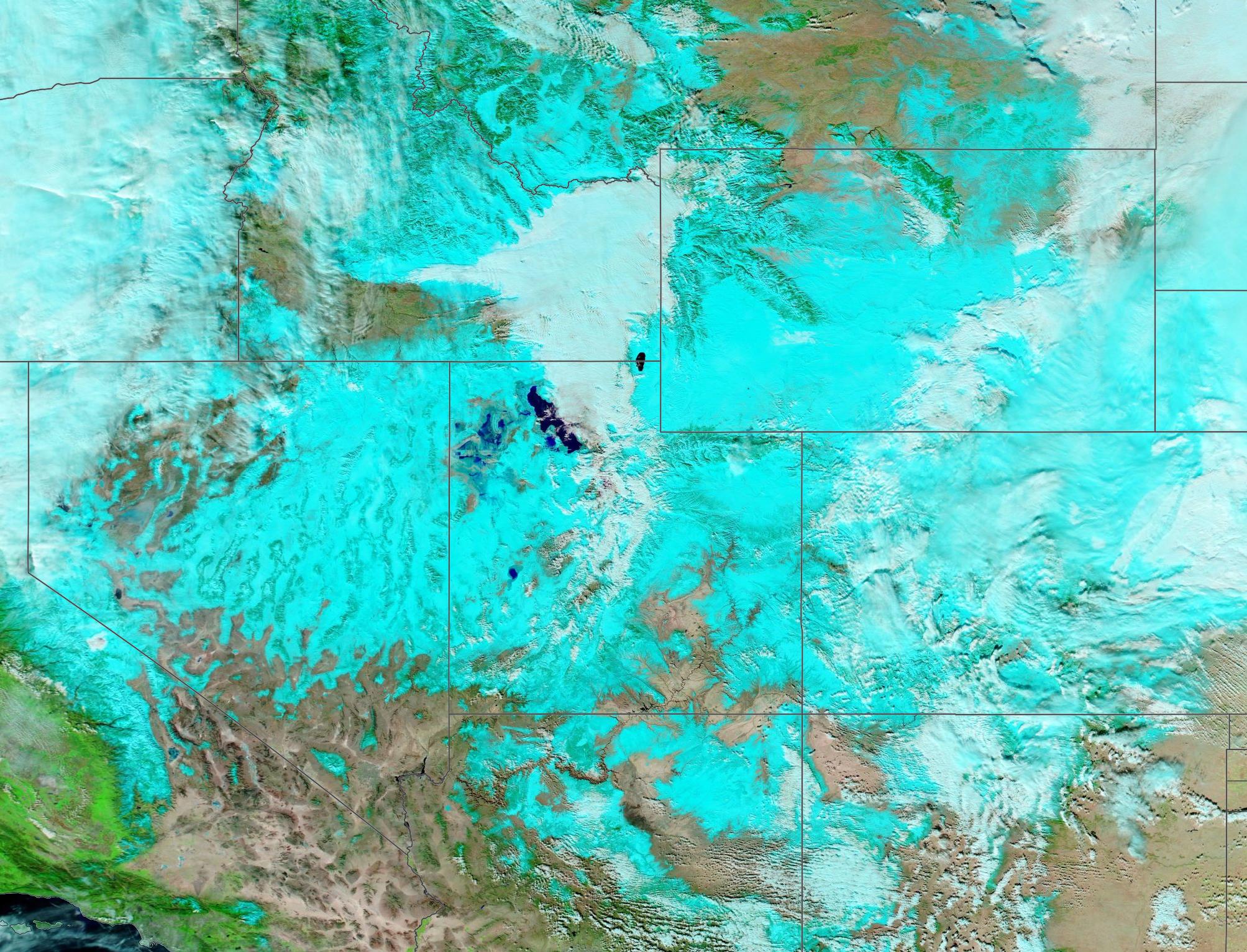
On January 19, the Moderate Resolution Imaging Spectroradiometer (MODIS) on board NASA’s Aqua satellite acquired a false-color image of the aftermath of the January 17-18 winter storm across the Western United States. In this type of false-color image, snow appears bright blue, open land looks tan, vegetation is electric green, and water looks deep blue. Clouds usually appear white but high, cold clouds that contain ice may have a tint of electric blue. In most locations, the freshly-fallen snow sits atop older accumulations dropped during the earlier winter storms.
The state of Utah sits in the center of the image, and is marked by the deep blue of the Great Salt Lake. From north and moving clockwise, other states seen in this image—in whole or part—are: Idaho, Montana, Wyoming, southwestern corner of North Dakota, western South Dakota, western Nebraska, Colorado, New Mexico, Arizona, Nevada, California, Oregon, and southeastern Washington.
Image Facts
Satellite:
Aqua
Date Acquired: 1/8/2023
Resolutions:
1km (630.1 KB), 500m (10.5 MB), 250m (7.1 MB)
Bands Used: 7,2,1
Image Credit:
MODIS Land Rapid Response Team, NASA GSFC
On January 19, 2023, after weathering several series of winter storms in the past two months, a local Denver, Colorado news company’s headline read, “Say it ain’t snow!”. But it was snow—and plenty of it. From January 17-18, the storm brought white-out conditions to Denver for several hours while 9.1 inches of new snow accumulated at Denver International Airport. That brings this storm to eighth place in Denver’s Top 10 two-day total accumulation for the month of January.
The best description of the event comes from the National Weather Service (NWS), which wrote, “An area of low pressure developed along the lee of the Rockies in eastern Colorado and tracked northeast across the Great Plains…Plentiful moisture and powerful dynamics of a system more typical of a springtime storm came together to result in a swath of significant snowfall.” The heaviest-hit area was western and north central Nebraska, where the single calendar day snowfall record was broken at North Platte, with a total of 13.9 inches of accumulation at that location. Two feet of snow were also recorded in Custer County, Nebraska.
On January 19, the Moderate Resolution Imaging Spectroradiometer (MODIS) on board NASA’s Aqua satellite acquired a false-color image of the aftermath of the January 17-18 winter storm across the Western United States. In this type of false-color image, snow appears bright blue, open land looks tan, vegetation is electric green, and water looks deep blue. Clouds usually appear white but high, cold clouds that contain ice may have a tint of electric blue. In most locations, the freshly-fallen snow sits atop older accumulations dropped during the earlier winter storms.
The state of Utah sits in the center of the image, and is marked by the deep blue of the Great Salt Lake. From north and moving clockwise, other states seen in this image—in whole or part—are: Idaho, Montana, Wyoming, southwestern corner of North Dakota, western South Dakota, western Nebraska, Colorado, New Mexico, Arizona, Nevada, California, Oregon, and southeastern Washington.
Image Facts
Satellite:
Aqua
Date Acquired: 1/8/2023
Resolutions:
1km (630.1 KB), 500m (10.5 MB), 250m (7.1 MB)
Bands Used: 7,2,1
Image Credit:
MODIS Land Rapid Response Team, NASA GSFC
