
Images


January 23, 2023 - Southern Patagonia Ice Field
 Tweet
Tweet
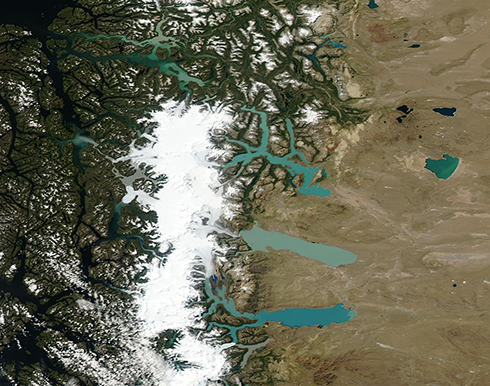
This stunning true-color image of a cloud-free summer day over the South Patagonian Icefield was acquired on January 17, 2023, by the Moderate Resolution Imaging Spectroradiometer (MODIS) on board NASA’s Aqua satellite.
Sitting atop the Andes Mountains in southern South America, the Patagonian Icefields are a remnant of a massive ice sheet that existed about 18,000 years ago. Today, the ancient ice sheet has withered to three remnants: the North, South, and Cordillera Darwin Icefields. These modern icefields still contain the largest expanse of ice in the Southern Hemisphere outside of Antarctica. only three icefields remain of the ancient ice sheet.
The Southern Icefield, shown in this image, is the largest of the three, stretching about 217 miles (250 km) along high Andes ridgetops. Scientists currently estimate the size at about 12,200 square kilometers (4,710 square miles), which is a little smaller than the size of the U.S. state of Connecticut. It’s about three times the size of the Northern Patagonian Icefield and both of those are much larger than the Cordillera Darwin Icefield, which sits at the farthest tip of the continent.
Several large and visually striking glacial lakes can be seen along the edges of the Southern Icefield, especially along the eastern side. The lakes are filled with meltwater from the Icefield glaciers as well as from meltwater from each winter’s fresh snowfall. As glaciers slowly slide along the mountains, their weight grinds the stone beneath into very fine sediment, which is known as “glacial flour”. Glacial meltwater carries the glacial flour into the lakes, creating the remarkable and unique teal-colored appearance.
Image Facts
Satellite:
Aqua
Date Acquired: 1/17/2023
Resolutions:
1km (239 KB), 500m (604.3 KB), 250m (430.7 KB)
Bands Used: 1,4,3
Image Credit:
MODIS Land Rapid Response Team, NASA GSFC
