
Images


January 30, 2023 - Snow Across the United States
 Tweet
Tweet
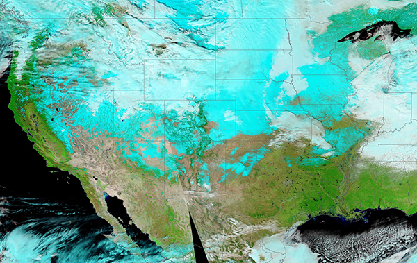
After several winter storms swept across the country in January 2023, snow blanketed most of the continental United States by January 26. The the Moderate Resolution Imaging Spectroradiometer (MODIS) on board NASA’s Aqua satellite acquired a sweeping false color image of the scene on that same day.
In this type of image, both infrared and visible light (bands 7,2,1) are combined to help differentiate snow from cloud. Snow shows up as bright blue, while most clouds appear white. Cold clouds that contain ice may also be tinted with a touch of bright blue. Vegetation looks electric green, water deep blue, and unvegetated land appears tan or brown.
In this image, snow reaches as far south as Arizona, New Mexico, and Texas west of the Mississippi River. Every state east of the Mississippi also wears at least a partial cover of either snow or cloud.
The most recent storm travelled across the Southwest, the Southern Plains, the Midwest, and the Northeast United States from January 23-26. Reports from Arizona measured more than a foot of snow in the high elevations in the north and center of that state. By January 25, a substantial dump of heavy, wet snow accompanied by winds gusting to 20 mph (32 km/h) caused widespread power outages. In south and central Missouri, more than 75,000 lost power. That region also accumulated up to 8 inches of fresh show.
Image Facts
Satellite:
Aqua
Date Acquired: 1/26/2023
Resolutions:
1km ( B),
Bands Used: 7,2,1
Image Credit:
MODIS Land Rapid Response Team, NASA GSFC
