
Images


January 31, 2023 - Flooding in Madagascar
 Tweet
Tweet
On January 19, 2023, Tropical Cyclone Cheneso struck northwestern Madagascar, bringing torrential rainfall across the region.
Maximum sustained winds at landfall were 66 miles per hour (106 km/h), which is below hurricane strength. While Madagascar’s National Office for Risk and Disaster Management reported wind gusts as high as 105.6 miles per hour (170 km/h), it was water, not wind, that caused most of the damage.
According to a story published on Floodlist, several cities saw very heavy rainfall, especially in the north. Between January 19 -20, the city of Sambava recorded 100 mm (3.94 inches) and 104 mm (4.1 inches) fell in Antsohihy. Unfortunately, the 24-hour total was only part of the inundation. Cheneso was a large, water-logged system with a slow approach to landfall, and an even slower crawl across the country. When the remnants of the storm moved off land and over the Mozambique Channel on January 23, Cheneso quickly roared back to life, becoming the equivalent of a major hurricane with a large span. As late as January 25, outer convective bands were still bringing rain to northern Madagascar.
Extensive flooding and landslides are blamed for at least 30 deaths in the country, with 20 people missing. More than 80,000 people have been adversely affected by the aftermath of Cheneso, with many still residing in shelters, almost two weeks after landfall. In addition, significant damage to infrastructure, including bridges and roads, and to crops have been reported.
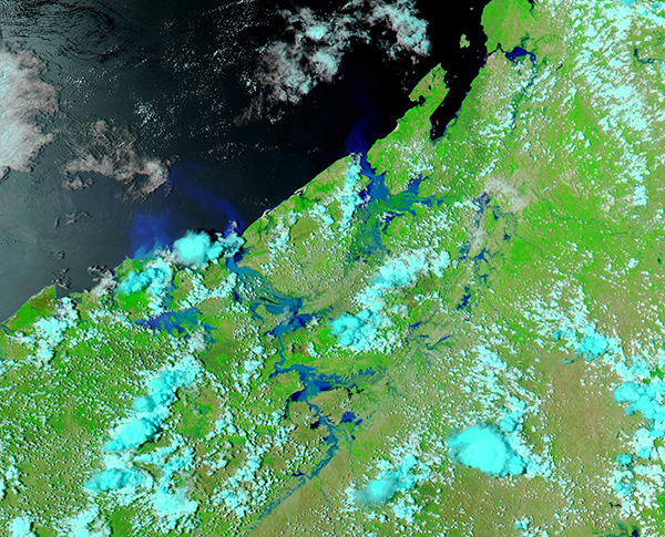
On January 30, 2023, the Moderate Resolution Imaging Spectroradiometer (MODIS) on board NASA’s Aqua satellite acquired a false-color image showing widespread flooding in northwestern Madagascar. The town of Antsohihy is located just northeast of center.
This type of false-color image uses infrared and visible light (bands 7,2,1) to help separate water from land. Vegetation appears bright green, open land is tan, and cloud may look either white or tinted with bright electric blue. Deep water, such as the Indian Ocean, takes on a deep inky blue hue while shallower water takes on lighter tones of blue.
While extensive flooding is easily visible in this image, the extent is better appreciated by viewing the same region prior to the passage of Tropical Cyclone Cheneso. Thanks to the NASA Worldview App, a rollover comparison of Aqua MODIS imagery of the same region on January 30 and January 2 can be viewed simply by clicking here.
The NASA Worldview app provides a satellite's perspective of the planet as it looks today and as it has in the past through daily satellite images. Worldview is part of NASA’s Earth Observing System Data and Information System. EOSDIS makes the agency's large repository of data accessible and freely available to the public.
Image Facts
Satellite:
Aqua
Date Acquired: 1/30/2023
Resolutions:
1km (281.5 KB), 500m (782.1 KB), 250m (508.8 KB)
Bands Used: 7,2,1
Image Credit:
MODIS Land Rapid Response Team, NASA GSFC
On January 19, 2023, Tropical Cyclone Cheneso struck northwestern Madagascar, bringing torrential rainfall across the region.
Maximum sustained winds at landfall were 66 miles per hour (106 km/h), which is below hurricane strength. While Madagascar’s National Office for Risk and Disaster Management reported wind gusts as high as 105.6 miles per hour (170 km/h), it was water, not wind, that caused most of the damage.
According to a story published on Floodlist, several cities saw very heavy rainfall, especially in the north. Between January 19 -20, the city of Sambava recorded 100 mm (3.94 inches) and 104 mm (4.1 inches) fell in Antsohihy. Unfortunately, the 24-hour total was only part of the inundation. Cheneso was a large, water-logged system with a slow approach to landfall, and an even slower crawl across the country. When the remnants of the storm moved off land and over the Mozambique Channel on January 23, Cheneso quickly roared back to life, becoming the equivalent of a major hurricane with a large span. As late as January 25, outer convective bands were still bringing rain to northern Madagascar.
Extensive flooding and landslides are blamed for at least 30 deaths in the country, with 20 people missing. More than 80,000 people have been adversely affected by the aftermath of Cheneso, with many still residing in shelters, almost two weeks after landfall. In addition, significant damage to infrastructure, including bridges and roads, and to crops have been reported.
On January 30, 2023, the Moderate Resolution Imaging Spectroradiometer (MODIS) on board NASA’s Aqua satellite acquired a false-color image showing widespread flooding in northwestern Madagascar. The town of Antsohihy is located just northeast of center.
This type of false-color image uses infrared and visible light (bands 7,2,1) to help separate water from land. Vegetation appears bright green, open land is tan, and cloud may look either white or tinted with bright electric blue. Deep water, such as the Indian Ocean, takes on a deep inky blue hue while shallower water takes on lighter tones of blue.
While extensive flooding is easily visible in this image, the extent is better appreciated by viewing the same region prior to the passage of Tropical Cyclone Cheneso. Thanks to the NASA Worldview App, a rollover comparison of Aqua MODIS imagery of the same region on January 30 and January 2 can be viewed simply by clicking here.
The NASA Worldview app provides a satellite's perspective of the planet as it looks today and as it has in the past through daily satellite images. Worldview is part of NASA’s Earth Observing System Data and Information System. EOSDIS makes the agency's large repository of data accessible and freely available to the public.
Image Facts
Satellite:
Aqua
Date Acquired: 1/30/2023
Resolutions:
1km (281.5 KB), 500m (782.1 KB), 250m (508.8 KB)
Bands Used: 7,2,1
Image Credit:
MODIS Land Rapid Response Team, NASA GSFC
