
Images


February 11, 2023 - Severe Tropical Cyclone Gabrielle
 Tweet
Tweet
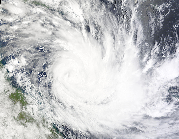
Tropical Cyclone Gabrielle sprung to life over the Coral Sea about 100 km (62 miles) off the coast of Queensland, Australia on February 8, 2023, and began to quickly intensify. By February 9, Gabrielle had become a Severe Tropical Cyclone with maximum sustained winds of 100 mph (161 km/h), placing it at Category 2 strength on the Saffir-Simpson Hurricane Wind Scale—and was still intensifying as it appeared to be making a beeline to New Zealand’s North Island.
The Moderate Resolution Imaging Spectroradiometer (MODIS) on board NASA’s Terra satellite acquired a true-color image of Severe Tropical Cyclone Gabrielle on the afternoon of February 9, as the storm was strengthening. The convective bands of the large system stretched from eastern Queensland to New Caledonia, bringing gusting winds, surf and rain to both. Queensland can be seen to the west of Gabrielle while New Caledonia, located to the southeast of the storm, is out of view just off the edge of the image.
On the day the image was captured, as Gabrielle neared its peak strength, the New Zealand Emergency Management Minister warned residents of North Island, particularly Auckland, to prepare for the worst, as Gabrielle is expected to pass close by between February 11-12. The small Norfolk Island, home to about 2,400 souls, declared a Red Alert, expecting the cyclone to make landfall sometime between February 10-11.
Fortunately, after peaking at 105 mph (169 km/h) early on February 10, Gabrielle began to rapidly weaken. The Australian Bureau of Meteorology (BOM) has kept the Red Alert for the Norfolk Islands, but it appears likely that the center of the storm is likely to pass just offshore rather than a direct hit. Steeply decreased winds will help islanders greatly, although high waves, wind, and rain is likely to still prove destructive.
At 4:00 p.m. EST (2100 UTC) on February 10, the Joint Typhoon Warning Center (JTWC) issued its last advisory on Gabrielle. At that time, maximum sustained winds had dropped to 63 mph (101 km/h) and the center was located about 671 miles (1,080 km) northwest of Auckland, New Zealand, which also means it was closely approaching Norfolk Island. At that time, satellite imagery showed that the storm’s low-level circulation had become ragged and fully exposed as central convection rapidly collapsed and became severely sheared. Maximum significant wave height was 35 feet (10.7 meters). The JTWC will monitor the system for regeneration.
Image Facts
Satellite:
Terra
Date Acquired: 2/9/2023
Resolutions:
1km (1.6 MB), 500m (1.2 MB),
Bands Used: 1,4,3
Image Credit:
MODIS Land Rapid Response Team, NASA GSFC
