
Images


March 4, 2023 - Tropical Cyclone Kevin Batters Beleaguered Vanuatu
 Tweet
Tweet
It’s been a tough few days for Vanuatu. Between February 27 and March 3, 2023, the beautiful South Pacific island nation has been battered by two severe tropical cyclones and two earthquakes. The situation was summed up by Port Vila-based journalist Dan McGarry, who tweeted on March 3, “Port Vila has properly woken up now’. That was followed by a quick situation summary, “Fuel is in short supply, power is out everywhere, and a boil-water order is in effect.” The government of Vanuatu declared a State of Emergency on March 2.
On February 27, Tropical Cyclone Judy was closing in on the northern islands of Vanuatu, carrying maximum sustained winds of about 75 mph (120 km/h). Unfortunately, it was intensifying. As the storm’s center passed only 4.4 miles (7 km) east of the small island of Port Vila, the location of the country’s capital, maximum sustained winds were 97.5 mph (157 km/h). That is the equivalent of a Category 2 storm on the Saffir-Simpson Hurricane Wind Scale. On March 1, as it made landfall on Tanna Island in southern Vanuatu, Tropical Cyclone Judy had reached peak strength as a Category 3 storm, with maximum sustained winds of 120 mph (193 km/h).
Less than 24 hours after Judy pulled away from Vanuatu, her big brother came calling. Tropical Cyclone Kevin slammed across the country as an even more powerful storm. As Kevin passed by Port Vila, maximum sustained winds were estimated at about 110 mph (177 km/h), or a strong Category 2 storm, but it was strengthening. As Kevin passed near Tanna Island, maximum sustained winds reached about 120 mph (193 km/h). At 0300 UTC on March 4 (10:00 p.m. EST on March 3), the Joint Typhoon Warning Center (JTWC) advised that Tropical Storm Kevin’s maximum sustained winds reached 150 mph (241 km/h), or a strong Category 4 storm. At that time, Kevin was pulling away from Vanuatu.
Meanwhile, while the citizens were taking cover from severe winds in their homes or in shelters, two earthquakes shook the country. A magnitude 6.5 quake struck 56 miles (90 km) from Luganville on the island of Espiritu Santo on March 2. Only an hour and a half later, a 5.4 magnitude earthquake struck 71 miles (114 km) away from that city.
No casualties have been reported from the quakes on Espiritu Santo, but the situation on outlying islands still remains unclear. Damage assessment from the dual hurricanes has just begun, with various reports of widespread damage including flooding, damaged or “flattened” buildings, and power outages. The Vanuatu Red Cross Secretary was quoted as saying on March 3, “We are still trying to establish communication with our branch in Tanna. We still have not heard anything since Cyclone Judy hit.” Tanna Island in the province of Tafea is expected to be the region worst affected by the hurricanes.
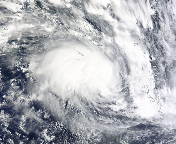
The Moderate Resolution Imaging Spectroradiometer (MODIS) on board NASA’s Terra satellite acquired a true-color image of Tropical Cyclone Kevin on March 2. Near the time the image was acquired, maximum sustained winds were estimated at about 70 mph (113 km/h), placing it at just under tropical storm strength. Rain bands reach over the Solomon Islands (north) while the islands of Vanuatu sit in the southeast, directly in the path of the rapidly strengthening storm.
Image Facts
Satellite:
Terra
Date Acquired: 3/2/2023
Resolutions:
1km (436.4 KB), 500m (1.3 MB), 250m (3.7 MB)
Bands Used: 1,4,3
Image Credit:
MODIS Land Rapid Response Team, NASA GSFC
It’s been a tough few days for Vanuatu. Between February 27 and March 3, 2023, the beautiful South Pacific island nation has been battered by two severe tropical cyclones and two earthquakes. The situation was summed up by Port Vila-based journalist Dan McGarry, who tweeted on March 3, “Port Vila has properly woken up now’. That was followed by a quick situation summary, “Fuel is in short supply, power is out everywhere, and a boil-water order is in effect.” The government of Vanuatu declared a State of Emergency on March 2.
On February 27, Tropical Cyclone Judy was closing in on the northern islands of Vanuatu, carrying maximum sustained winds of about 75 mph (120 km/h). Unfortunately, it was intensifying. As the storm’s center passed only 4.4 miles (7 km) east of the small island of Port Vila, the location of the country’s capital, maximum sustained winds were 97.5 mph (157 km/h). That is the equivalent of a Category 2 storm on the Saffir-Simpson Hurricane Wind Scale. On March 1, as it made landfall on Tanna Island in southern Vanuatu, Tropical Cyclone Judy had reached peak strength as a Category 3 storm, with maximum sustained winds of 120 mph (193 km/h).
Less than 24 hours after Judy pulled away from Vanuatu, her big brother came calling. Tropical Cyclone Kevin slammed across the country as an even more powerful storm. As Kevin passed by Port Vila, maximum sustained winds were estimated at about 110 mph (177 km/h), or a strong Category 2 storm, but it was strengthening. As Kevin passed near Tanna Island, maximum sustained winds reached about 120 mph (193 km/h). At 0300 UTC on March 4 (10:00 p.m. EST on March 3), the Joint Typhoon Warning Center (JTWC) advised that Tropical Storm Kevin’s maximum sustained winds reached 150 mph (241 km/h), or a strong Category 4 storm. At that time, Kevin was pulling away from Vanuatu.
Meanwhile, while the citizens were taking cover from severe winds in their homes or in shelters, two earthquakes shook the country. A magnitude 6.5 quake struck 56 miles (90 km) from Luganville on the island of Espiritu Santo on March 2. Only an hour and a half later, a 5.4 magnitude earthquake struck 71 miles (114 km) away from that city.
No casualties have been reported from the quakes on Espiritu Santo, but the situation on outlying islands still remains unclear. Damage assessment from the dual hurricanes has just begun, with various reports of widespread damage including flooding, damaged or “flattened” buildings, and power outages. The Vanuatu Red Cross Secretary was quoted as saying on March 3, “We are still trying to establish communication with our branch in Tanna. We still have not heard anything since Cyclone Judy hit.” Tanna Island in the province of Tafea is expected to be the region worst affected by the hurricanes.
The Moderate Resolution Imaging Spectroradiometer (MODIS) on board NASA’s Terra satellite acquired a true-color image of Tropical Cyclone Kevin on March 2. Near the time the image was acquired, maximum sustained winds were estimated at about 70 mph (113 km/h), placing it at just under tropical storm strength. Rain bands reach over the Solomon Islands (north) while the islands of Vanuatu sit in the southeast, directly in the path of the rapidly strengthening storm.
Image Facts
Satellite:
Terra
Date Acquired: 3/2/2023
Resolutions:
1km (436.4 KB), 500m (1.3 MB), 250m (3.7 MB)
Bands Used: 1,4,3
Image Credit:
MODIS Land Rapid Response Team, NASA GSFC
