
Images


March 9, 2023 - Fires in the Southeastern United States
 Tweet
Tweet
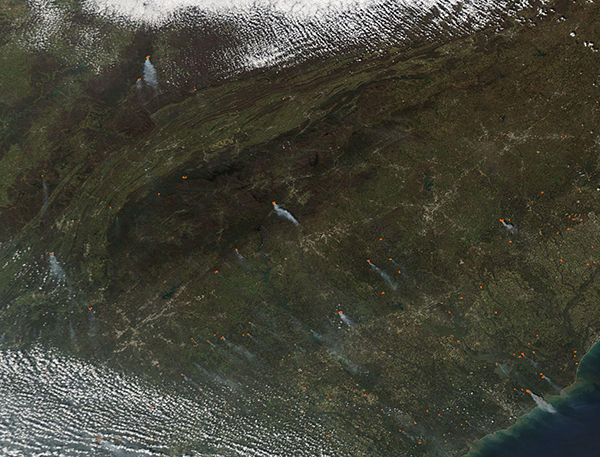
Dozens of fires were burning across the Southeastern United States on March 7, 2023, when the Moderate Resolution Imaging Spectroradiometer (MODIS) on board NASA’s Aqua satellite acquired a true-color image of the region.
Six states are visible between the clouds in this image. Starting in the northeast and moving clockwise, they are Kentucky, Virginia, North Carolina, South Carolina, Georgia, Alabama, and Tennessee. Active fires are present in all states, with the highest number visible in Piedmont and Coastal regions of North Carolina, South Carolina, and Georgia.
Given the time of year, the number of fires, and their location, it is likely that most of these fires are either prescribed burns or agricultural in origin. The Southeastern United States is agriculturally rich, and fire is a useful tool used to clear old crops, renew pastureland, and open new areas for use. Early March is prime time to prepare ground and plant new crops.
Fire is also essential in some fire-dependent ecosystems, such as the southeastern oak and pine savannas. The southern pine ecosystem, the only home to the endangered Red Cockaded Woodpecker, is adapted to slow-burning, low-intensity and frequent wildfires. Prescribed burns, deliberately set and managed to clear underbrush, help sustain fire-adapted ecosystems as well as prevent high-intensity burns in forests or grasslands where brush is allowed to overgrow.
While most of these fires are deliberately set, some wildfires are currently burning. According to state fire management links on the National Interagency Fire Center’s website, North Carolina reports 94 wildfires burning on about 450 acres across the state on March 7. None of these are large enough to be reported on the Inciweb Incident Information System, however.
Image Facts
Satellite:
Aqua
Date Acquired: 3/7/2023
Resolutions:
1km (93.2 KB), 500m (335.7 KB), 250m (1 MB)
Bands Used: 1,4,3
Image Credit:
MODIS Land Rapid Response Team, NASA GSFC
