
Images


April 14, 2023 - Burn Scars across Eastern Kansas
April 12, 2023
March 19, 2023
Tweet
Strong winds, unseasonably warm air temperatures, and extremely dry prairie grasses set the stage for an outbreak of wildfires in Kansas between late March and early April 2023. Firefighters had their hands full battling dozens of fires, both large and small.
While the cause of most of the wildfires wasn’t known, others were due to escaped fires ignited to manage land. According to the Riley County government website, two major fires in that county on April 10 were prescribed burns that got out of control. Combined, they had burnt more than 3,500 acres. Prescribed burns are used to manage agricultural lands and prairie grassland, and spring is a prime time for such burns. Such burns are typically closely managed, but may escape control even in the best of conditions. In extreme fire weather, such as experienced in central and eastern Kansas over the last month, escaped burns can quickly become catastrophic.
On April 12, Kansas Governor Laura Kelly issued a verbal declaration of disaster emergency, due to the amount of wildland fires across the state. According to the state Fire Service website, as of April 13 much of Kansas is under Red Flag Warnings-Extreme Fire Danger due to high winds and low relative humidity. The report states, “Fire departments in many areas have been run ragged with multiple fires a day, and multi-day fires recently. Most of KS remains very dry, and getting warmer. Fire danger indices are at or above the 95th percentile in all but the southeast, where greenup is progressing.”
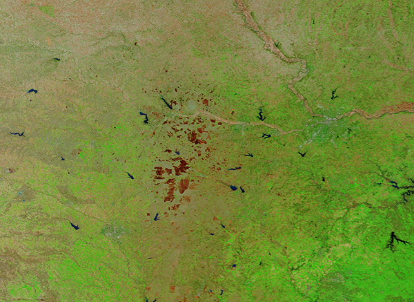
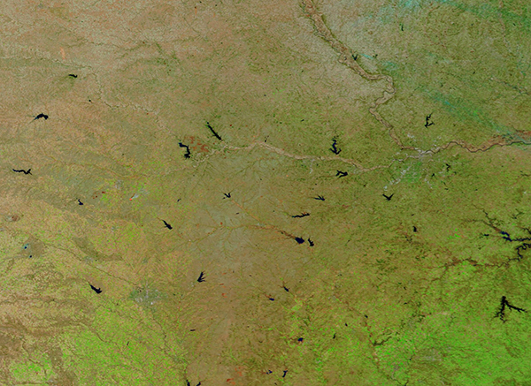
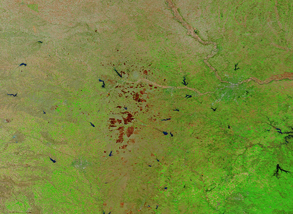
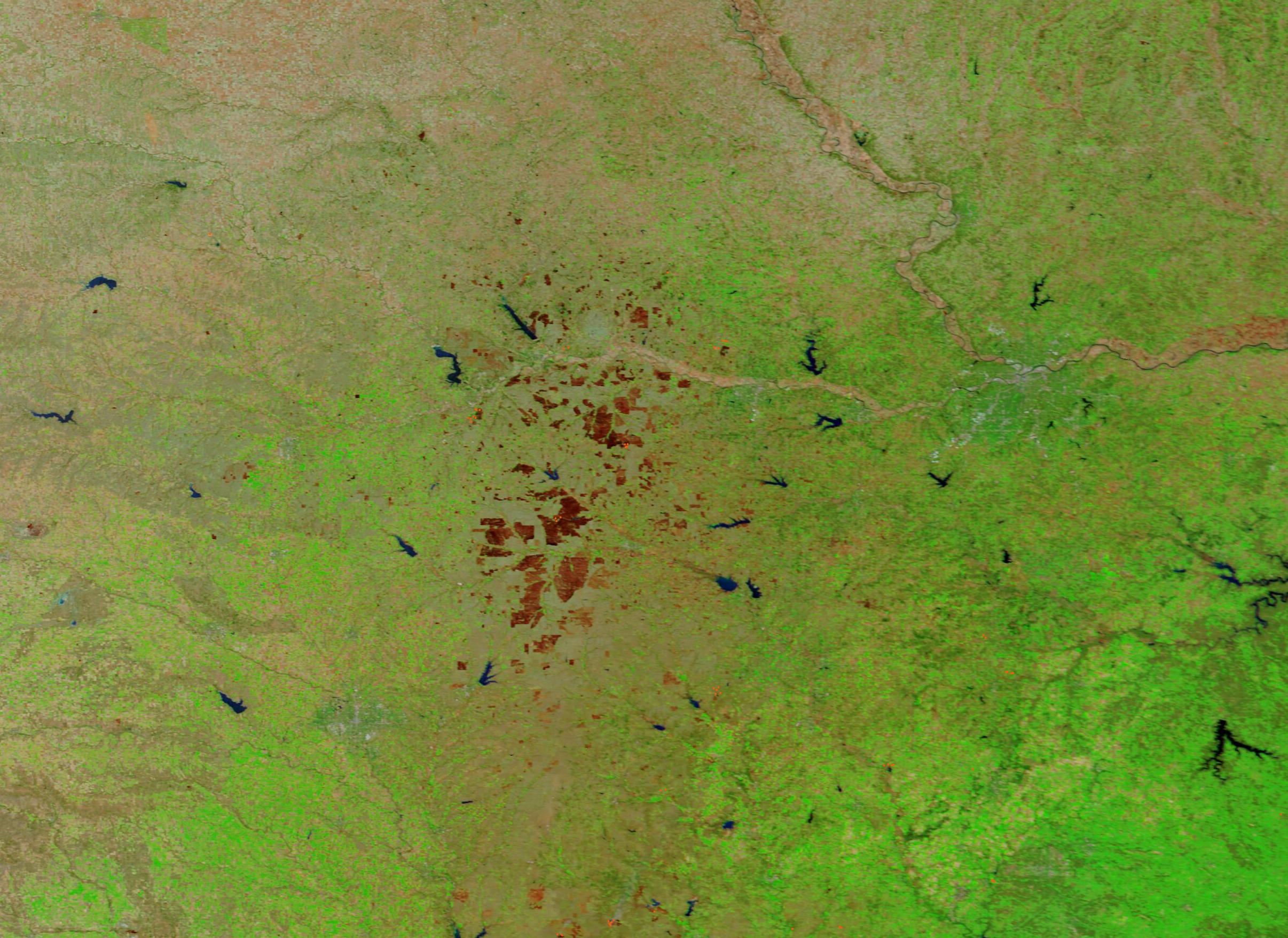
The Moderate Resolution Imaging Spectroradiometer (MODIS) on board NASA’s Terra satellite acquired two false-color images of eastern Kansas, one on April 12 and the other on March 19. The images are easily compared by tapping on the dates to toggle between the two.
In this type of false-color image, vegetation appears green, open land looks tan or brown, and water is blue. In addition, burn scars—areas recently scorched by fire—may appear brown, brick red, or black, depending on various factors such as the soil type, the heat of the burn, how long ago the burn occurred, and if any vegetation remained or regrew in the scar. In the April 12 image, it is easy to see an abundance of brick-red burn scars. The majority of these sit in a rough triangle between the towns of Topeka (northeast), Manhattan (northwest), and Wichita (south and west of Manhattan). Toggling to the March 19 image, it’s obvious that these are all very recent burns. In fact, a few have active fires (red hot spots) at their edges.
Image Facts
Satellite:
Terra
Date Acquired: 4/12/2023
Resolutions:
1km (397 KB), 500m (878.6 KB), 250m (559.5 KB)
Bands Used: 1,4,3
Image Credit:
MODIS Land Rapid Response Team, NASA GSFC
April 12, 2023 March 19, 2023
Strong winds, unseasonably warm air temperatures, and extremely dry prairie grasses set the stage for an outbreak of wildfires in Kansas between late March and early April 2023. Firefighters had their hands full battling dozens of fires, both large and small.
While the cause of most of the wildfires wasn’t known, others were due to escaped fires ignited to manage land. According to the Riley County government website, two major fires in that county on April 10 were prescribed burns that got out of control. Combined, they had burnt more than 3,500 acres. Prescribed burns are used to manage agricultural lands and prairie grassland, and spring is a prime time for such burns. Such burns are typically closely managed, but may escape control even in the best of conditions. In extreme fire weather, such as experienced in central and eastern Kansas over the last month, escaped burns can quickly become catastrophic.
On April 12, Kansas Governor Laura Kelly issued a verbal declaration of disaster emergency, due to the amount of wildland fires across the state. According to the state Fire Service website, as of April 13 much of Kansas is under Red Flag Warnings-Extreme Fire Danger due to high winds and low relative humidity. The report states, “Fire departments in many areas have been run ragged with multiple fires a day, and multi-day fires recently. Most of KS remains very dry, and getting warmer. Fire danger indices are at or above the 95th percentile in all but the southeast, where greenup is progressing.”
The Moderate Resolution Imaging Spectroradiometer (MODIS) on board NASA’s Terra satellite acquired two false-color images of eastern Kansas, one on April 12 and the other on March 19. The images are easily compared by tapping on the dates to toggle between the two.
In this type of false-color image, vegetation appears green, open land looks tan or brown, and water is blue. In addition, burn scars—areas recently scorched by fire—may appear brown, brick red, or black, depending on various factors such as the soil type, the heat of the burn, how long ago the burn occurred, and if any vegetation remained or regrew in the scar. In the April 12 image, it is easy to see an abundance of brick-red burn scars. The majority of these sit in a rough triangle between the towns of Topeka (northeast), Manhattan (northwest), and Wichita (south and west of Manhattan). Toggling to the March 19 image, it’s obvious that these are all very recent burns. In fact, a few have active fires (red hot spots) at their edges.
Image Facts
Satellite:
Terra
Date Acquired: 4/12/2023
Resolutions:
1km (397 KB), 500m (878.6 KB), 250m (559.5 KB)
Bands Used: 1,4,3
Image Credit:
MODIS Land Rapid Response Team, NASA GSFC
