
Images


April 26, 2023 - Australia's Red Centre
 Tweet
Tweet
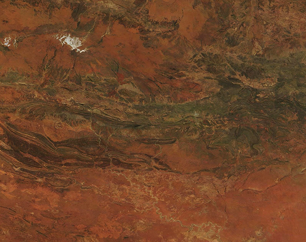
Red and orange outback along with weathered mountain ridges dominate the landscape of Australia’s Red Centre in this true-color image acquired by the Moderate Resolution Imaging Spectroradiometer (MODIS) on board NASA’s Terra satellite on April 24, 2023.
The Red Centre is the local name given to the southern desert region of Australia’s Northern Territory, and gets its name not only because it contains the median center point of Australia, said to be located west of the Stuart Highway and south of Alice Springs, but because of the stunning red tone of the soils. According to the National Oceanic and Atmospheric Administration (NOAA), Australia happens to have a perfect environment for a form of chemical weathering called oxidation, which occurs in rocks that contain high amounts of iron. In a hot, dry environment, these types of rocks actually begin to rust. As the rust expands, it weakens the rock and helps break it apart. The oxides produced through this process give the ground its reddish hue.
The folded mountains that span this image are the MacDonnell Range. The worn, parallel ridges were formed 300-350 million years ago and contain not only granite, limestone, sandstone, and siltstone rocks, but also stunning red quartzite peaks and gorges. In some areas, dry scrubby grassland, known as a xeric shrub ecosystem, provides habitat for several unusual endemic species. A patch of gray pixels can be seen crossing the mountainous landscape roughly one-third of the way from the right (east) side of the image. This is the town of Alice Springs, the third-largest town of Northern Territory and the only town of any size in the Red Centre.
Image Facts
Satellite:
Terra
Date Acquired: 4/24/2023
Resolutions:
1km (208.4 KB), 500m (555.5 KB), 250m (327.7 KB)
Bands Used: 1,4,3
Image Credit:
MODIS Land Rapid Response Team, NASA GSFC
