
Images


May 12, 2023 - Potentially Disastrous Tropical Cyclone Mocha forms in the Bay of Bengal
 Tweet
Tweet
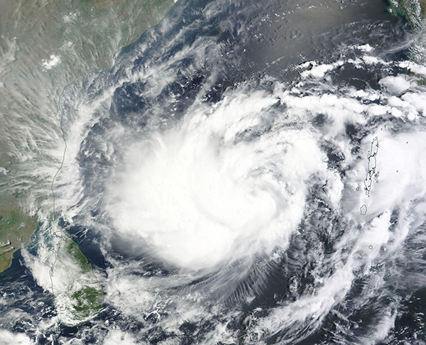
On May 11, 2023, the Moderate Resolution Imaging Spectroradiometer (MODIS) on NASA’s Terra satellite acquired a true-color image of newly-formed Tropical Cyclone Mocha as it strengthened over the Bay of Bengal.
At 11:00 p.m. EDT on May 11 (0300 UTC on May 12), the Joint Typhoon Warning Center (JTWC) estimated that Mocha was located approximately 670 miles (1,078 km) south-southwest of Coxs Bazar, Bangladesh and was tracking northward at 7 mph (11.3 km/h). It was carrying maximum sustained winds very close to 75 mph (121 km/h), which would place it equivalent to a Category 1 storm on the Saffir-Simpson Hurricane Wind Scale. It was pushing waves of 28 feet (8.5 meters).
Tropical Cyclone Mocha is expected to turn towards the northeast and rapidly intensify as it will be moving over water with warm sea surface temperatures and low wind shear. In this advisory, the JTWC raised its estimate of maximum strength to 147.3 mph (237 km/h), equivalent to a strong Category 4 storm, within 48 hours. Mocha is expected to make landfall near Sittwe City, the capital of Rakhine State, western Myanmar near southeastern Bangladesh at about maximum strength.
Such a strong storm could bring substantial destruction anywhere, but this location is at exceptional risk. The landscape is low-lying over a very broad area and thus vulnerable to widespread flooding, landslides, and other damage from storm surge. Poverty and a civil war mean that infrastructure is poor, especially in refugee camps. Kutupalong Refugee Camp, located in the Coxs Bazar region, is home to more than a half of a million people.
The Global Disaster Alert and Coordination System (GDACS) has issued an Overall Red Alert for Tropical Cyclone Mocha. The Alert is for May 11-14 in Myanmar, Bangladesh, and India. They advise that 2.7 million people will be exposed to Category 1 strength winds (75 mph/121 kmh) or higher and place Bangladesh at “High” vulnerability. Maximum storm surge is expected to be 1.7 meters (5.6 feet). The average elevation of Bangladesh has been estimated at about 9 meters (29.5 feet), with most of the urban population in lower-lying areas.
Image Facts
Satellite:
Terra
Date Acquired: 5/11/2023
Resolutions:
1km (439.3 KB), 500m (3.1 MB), 250m (4.1 MB)
Bands Used: 1,4,3
Image Credit:
MODIS Land Rapid Response Team, NASA GSFC
