
Images


May 14, 2023 - Lake Tana
 Tweet
Tweet
Lake Tana is Ethiopia’s largest lake, the main source of the Blue Nile River, and a hotspot of biodiversity. It was designated as a UNESCO Biosphere Reserve in 2014 and is also recognized by BirdLife International as an Important Bird Area (IBA).
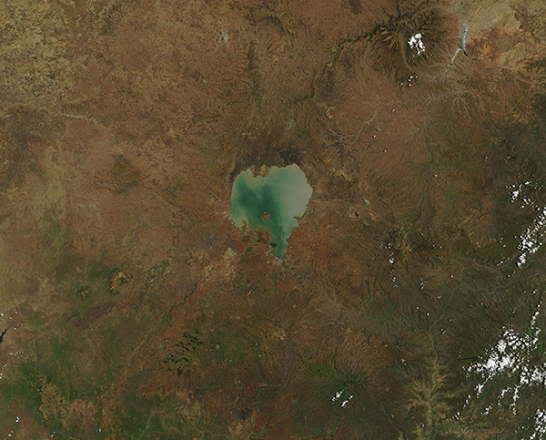
The lake sits in the northwest corner of the Ethiopian plateau about 350 miles (563 km) northwest of Addis Ababa. Lake Tana is very shallow, with a maximum depth of 45 feet (14 meters). This shallow depth allows sediment to swirl in the lake, carried by currents caused by the 60 rivers that pour into the lake or by strong winds. Sediment can color the water in shades of tan or green, and frequent algae blooms can also tint the lake with a green tone. There are 37 islands in Lake Tana, many of which support large colonies of birds while others are sites of ancient churches and monasteries.
Because of the location of Lake Tana, it is an important stopover and wintering site for many migratory birds on the flyway between Europe, Asia and Africa. The large undisturbed reedbeds around the lake serve as breeding, feeding, and roosting sites for endemic and rare species, such as the Wattled Crane and Black-crowned Crane and are essential for their survival.
On May 11, 2023, the Moderate Resolution Imaging Spectroradiometer (MODIS) on board NASA’s Terra satellite acquired a true-color image of Lake Tana. The multi-colored waters of the lake stand out in high contrast to the rugged Ethiopian plateau surrounding the lake. Dek Island, the largest of Lake Tana’s many islands, is easily visible in the southwestern section of the lake.
Image Facts
Satellite:
Terra
Date Acquired: 5/11/2023
Resolutions:
1km (178.6 KB), 500m (501.7 KB), 250m (351.8 KB)
Bands Used: 1,4,3
Image Credit:
MODIS Land Rapid Response Team, NASA GSFC
Lake Tana is Ethiopia’s largest lake, the main source of the Blue Nile River, and a hotspot of biodiversity. It was designated as a UNESCO Biosphere Reserve in 2014 and is also recognized by BirdLife International as an Important Bird Area (IBA).
The lake sits in the northwest corner of the Ethiopian plateau about 350 miles (563 km) northwest of Addis Ababa. Lake Tana is very shallow, with a maximum depth of 45 feet (14 meters). This shallow depth allows sediment to swirl in the lake, carried by currents caused by the 60 rivers that pour into the lake or by strong winds. Sediment can color the water in shades of tan or green, and frequent algae blooms can also tint the lake with a green tone. There are 37 islands in Lake Tana, many of which support large colonies of birds while others are sites of ancient churches and monasteries.
Because of the location of Lake Tana, it is an important stopover and wintering site for many migratory birds on the flyway between Europe, Asia and Africa. The large undisturbed reedbeds around the lake serve as breeding, feeding, and roosting sites for endemic and rare species, such as the Wattled Crane and Black-crowned Crane and are essential for their survival.
On May 11, 2023, the Moderate Resolution Imaging Spectroradiometer (MODIS) on board NASA’s Terra satellite acquired a true-color image of Lake Tana. The multi-colored waters of the lake stand out in high contrast to the rugged Ethiopian plateau surrounding the lake. Dek Island, the largest of Lake Tana’s many islands, is easily visible in the southwestern section of the lake.
Image Facts
Satellite:
Terra
Date Acquired: 5/11/2023
Resolutions:
1km (178.6 KB), 500m (501.7 KB), 250m (351.8 KB)
Bands Used: 1,4,3
Image Credit:
MODIS Land Rapid Response Team, NASA GSFC
