
Images


May 19, 2023 - South America's Pantanal
 Tweet
Tweet
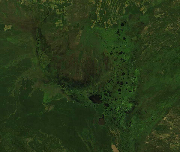
Sprawling across an area the size of the U.S. state of Washington, the Pantanal is Earth’s largest tropical wetland. The Pantanal is also one of the most biologically rich environments in the world, giving a home to more than 4,700 animal and plant species, including South America’s highest concentration of the jaguar. Sitting in the center of South America, the roughly 42 million acres that comprise this wetland belong primarily to Brazil, but Bolivia and Paraguay also share in the richness of this region.
The rhythm of life in this amazing wetland is dependent on the annual cycle of wet and dry seasons. Each year between October and April, torrential rains pour across the landscape, causing several major rivers including the Paraguay River to overflow. The widespread flooding creates large pools which spur reproduction of fish, attract many species of birds, and impel luxurious plant growth. When the rains come to an end, the water slowly recedes, leaving shallow pools which concentrate fish populations into a buffet-style feast for wading birds and even some mammals. By May, residents begin to clear fields and plant crops, while local cattle ranchers move their herds into the region to feed on luxuriant grasses. Farmers often use fire to manage the land for agriculture, and the dry Pantanal is very vulnerable to severe damage when fire is overused or when it escapes control to become a wildfire.
On May 17, 2023, the Moderate Resolution Imaging Spectroradiometer (MODIS) on NASA’s Terra satellite acquired a true-color image of a portion of the Pantanal at the end of rainy season. This image is centered near the border between Bolivia (west) and Brazil (east). The entire region is colored deep green from luxurious vegetation and is filled with flooded waterways that create numerous lakes and potholes.
With the NASA Worldview App, it is easy to compare this image with a Terra MODIS image acquired on Aug 11, 2022, simply by clicking here.
By using the arrow to scroll between the two images, the large differences between the end of the wet season (May) and the approach of the end of the dry season (August) are easily appreciated.
Image Facts
Satellite:
Terra
Date Acquired: 5/17/2023
Resolutions:
1km (59.8 KB), 500m (139.5 KB), 250m (263.6 KB)
Bands Used: 1,4,3
Image Credit:
MODIS Land Rapid Response Team, NASA GSFC
Sprawling across an area the size of the U.S. state of Washington, the Pantanal is Earth’s largest tropical wetland. The Pantanal is also one of the most biologically rich environments in the world, giving a home to more than 4,700 animal and plant species, including South America’s highest concentration of the jaguar. Sitting in the center of South America, the roughly 42 million acres that comprise this wetland belong primarily to Brazil, but Bolivia and Paraguay also share in the richness of this region.
The rhythm of life in this amazing wetland is dependent on the annual cycle of wet and dry seasons. Each year between October and April, torrential rains pour across the landscape, causing several major rivers including the Paraguay River to overflow. The widespread flooding creates large pools which spur reproduction of fish, attract many species of birds, and impel luxurious plant growth. When the rains come to an end, the water slowly recedes, leaving shallow pools which concentrate fish populations into a buffet-style feast for wading birds and even some mammals. By May, residents begin to clear fields and plant crops, while local cattle ranchers move their herds into the region to feed on luxuriant grasses. Farmers often use fire to manage the land for agriculture, and the dry Pantanal is very vulnerable to severe damage when fire is overused or when it escapes control to become a wildfire.
On May 17, 2023, the Moderate Resolution Imaging Spectroradiometer (MODIS) on NASA’s Terra satellite acquired a true-color image of a portion of the Pantanal at the end of rainy season. This image is centered near the border between Bolivia (west) and Brazil (east). The entire region is colored deep green from luxurious vegetation and is filled with flooded waterways that create numerous lakes and potholes.
With the NASA Worldview App, it is easy to compare this image with a Terra MODIS image acquired on Aug 11, 2022, simply by clicking here. By using the arrow to scroll between the two images, the large differences between the end of the wet season (May) and the approach of the end of the dry season (August) are easily appreciated.
Image Facts
Satellite:
Terra
Date Acquired: 5/17/2023
Resolutions:
1km (59.8 KB), 500m (139.5 KB), 250m (263.6 KB)
Bands Used: 1,4,3
Image Credit:
MODIS Land Rapid Response Team, NASA GSFC
