
Images


May 23, 2023 - Typhoon Mawar Takes Aim at Guam
 Tweet
Tweet
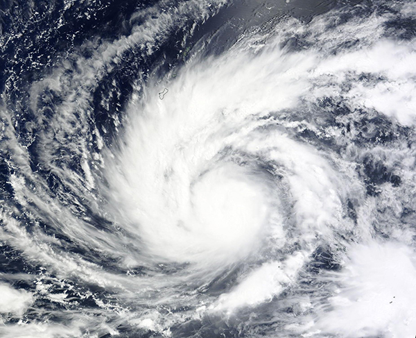
Typhoon Mawar formed over the North Pacific Ocean south of the Chuuk Islands on May 20, 2023. Since that time, the typhoon has been strengthening as it takes aim at the island of Guam. The Moderate Resolution Imaging Spectroradiometer (MODIS) on board NASA’s Terra satellite acquired a true-color image of the dangerous storm on May 22 as it was beginning a cycle of rapid intensification.
At 11:00 p.m. EST on May 22 (0300 UTC on May 23), the Joint Typhoon Warning Center (JTWC) advised that Typhoon Mawar was located about 219 miles (352 km) southeast of Andersen Air Force Base, Guam and was tracking northward at 8 mph (12.9 km/h). At that time, maximum sustained winds were 132 mph (212 km/h), which is the equivalent of a Category 4 storm on the Saffir-Simpson Hurricane Wind Scale. Gusts were estimated at 161 mph (259 km/h).
Typhoon Mawar has been undergoing rapid intensification since about 11:00 a.m. EDT (0300 UTC) on May 22, and at 11:00 p.m. EDT that evening (0300 UTC May 23), the JTWC stated that it was showing signs of further rapid intensification. The outer bands of the northwest quadrant of the storm had reached Guam, Rota, and the Northern Mariana Islands. Andersen Air Force Base had reported wind gusts up to 29 mph (46.7 km/h).
With Mawar moving over very warm waters and low wind shear, conditions are favorable for increased strengthening. The storm is predicted to cross Guam in the evening of May 23 as a strong Category 4 storm, with maximum sustained winds of about 145 mph (231.2 km/h) and gusts of 172 mph (276.8 km/h). After passing over Guam, Typhoon Mawar is expected to continue to strengthen, reaching peak maximum wind speed of about 150 mph (241 km/h) before it begins to weaken.
The National Weather Service has predicted a storm surge of four to six feet (1.2 to 1.8 meters), with the potential to reach 8 feet (2.4 meters) in the northern eyewall. Between May 23 through May 24, torrential rains of 8 to 15 inches (20 to 38 cm) are anticipated with high surf of 15-25 feet (4.6 to 6 meters).
Image Facts
Satellite:
Terra
Date Acquired: 5/22/2023
Resolutions:
1km (368.6 KB), 500m (1.1 MB), 250m (3.3 MB)
Bands Used: 1,4,3
Image Credit:
MODIS Land Rapid Response Team, NASA GSFC
