
Images


May 24, 2023 - Mountains in the Clouds
 Tweet
Tweet
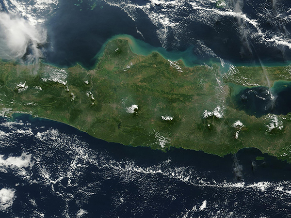
Indonesia is a highly volcanic archipelago stretching between the Pacific Ocean and the Indian Ocean in Southeast Asia. Java, an island in Indonesia’s Greater Sunda Islands, covers about 48,036 square miles (124,413 sq km) and is said to be the most heavily populated island in the world. Aside from people, Java is also densely populated by volcanoes, packing 112 volcanoes in its roughly North Carolina-sized footprint, 35 of which are active. Many are also quite tall, with Mount Semeru, at 12,060 feet (3,676 meters), taking the title of highest.
On May 22, 2023, the Moderate Resolution Imaging Spectroradiometer (MODIS) on board NASA’s Terra satellite acquired a true-color image of a portion of Java. Tall volcanic peaks rise high off a background of gorgeous green plains, each surrounded by cloud. This is especially noticeable along the mountain range that runs east-west along Java’s spine. Mount Semeru sports a clearly-defined semi-circle of cloud around its peak and is the second volcano from the right edge of the image.
The clouds are the result of a meteorological phenomenon called “valley wind.” During the day, the Sun warms the air in the valleys and by afternoon causes it to rise up the slopes of the mountains. As the warm, moist air rises, it cools and condenses into clouds over the volcanoes, or around their highest peaks.
Sea breezes could have contributed to the cloud growth, too. As the land warms during the day, the temperature difference between the land and sea surfaces causes winds to blow onshore. Moist sea breezes combine with valley winds and move up toward the mountaintops, adding to the ease of cloud formation.
Image Facts
Satellite:
Terra
Date Acquired: 5/22/2023
Resolutions:
1km (266.3 KB), 500m (780.4 KB), 250m (2 MB)
Bands Used: 1,4,3
Image Credit:
MODIS Land Rapid Response Team, NASA GSFC
