
Images


June 9, 2023 - Typhoon Guchol
 Tweet
Tweet
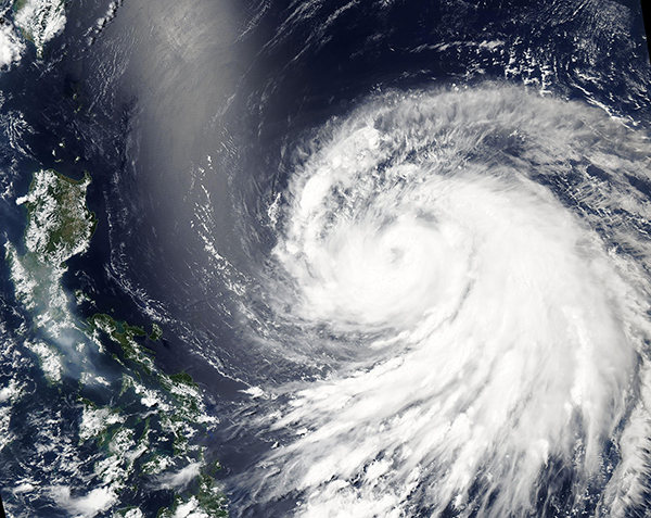
On June 8, 2023, the Moderate Resolution Imaging Spectroradiometer (MODIS) on NASA’s Aqua satellite acquired a true-color image of Typhoon Guchol (Chedeng) as it strengthened over the Philippine Sea. Near the time this image was captured, Typhoon Guchol was a large storm carrying maximum sustained winds of about 90 mph (145 m/h) (Category 1 on the Saffir-Simpson Hurricane Wind Scale).
Since its formation north of Palau on June 6, Guchol had been traveling westward, appearing to be taking aim at the Philippines. However, as the typhoon’s asymmetric shape illustrates, Guchol has run into difficult conditions between the storm and the Philippines. The adverse conditions sheared the western side of the storm, but also has shifted Guchol’s track towards the northeast. The shiny silver streak visible west of the storm is not associated with either the typhoon or wind shear, and it has no effect on weather conditions. It is an optical phenomenon called “sun glint” which occurs when the rays of the sun reflect off the water and directly back to the sensor.
At 11:00 pm EDT on June 8 (0300 UTC June 9), the Joint Typhoon Warning Center (JTWC) advised that Typhoon Guchol was carrying maximum sustained winds of 92 mph (148 km/h) and was located about 663 miles (1,067 km) south-southeast of Kadena Air Base, Okinawa, Japan and was traveling north-northwestward. The storm was still strengthening, but peak winds are expected to reach 98 mph (158 km/h) on June 9 before winds begin to weaken. Typhoon Guchol is expected to continue to travel northwestward, avoiding landfall on either the Philippines or Japan.
Image Facts
Satellite:
Aqua
Date Acquired: 6/8/2023
Resolutions:
1km (2.2 MB), 500m (1.7 MB),
Bands Used: 1,4,3
Image Credit:
MODIS Land Rapid Response Team, NASA GSFC
