
Images


June 15, 2023 - Dasht-e Lut, Iran
 Tweet
Tweet
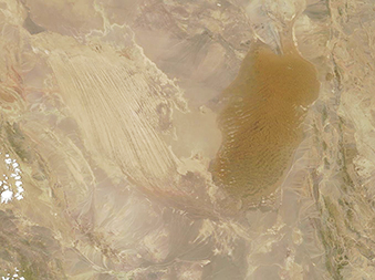
The arid expanse of southeastern Iran contains a rich variety of spectacular desert landforms, and the Dasht-e Lut (Lut Desert) is one of the most breathtaking. In the Persian language, the word “Lut” is used to describe extremely dry, bare land that is devoid of vegetation—an apt description of this hyper-arid and searingly hot region. The Moderate Resolution Imaging Spectroradiometer (MODIS) on board NASA’s Terra satellite acquired a true-color image of the rich colors and contours of the Dasht-e Lut on June 14, 2023.
The formations found in the Dasht-e Lut are so unique that it was inscribed as a UNESCO World Heritage Site in 2016. One striking feature is a field of yardangs—massive and dramatic folds that stretch across the desert, with ridges and corridors oriented parallel to the dominant prevailing winds. These sit in the western side of Dasht-e Lut and have been essentially “sand blasted” into existence from sand-filled, relentless winds whip across the desert every year between June and October.
In the east, the Dasht-e Lut is filled with a huge sand sea (erg), which appears in this image as a tan area filled with long rippling lines. These actively moving dunes, which are slowly blown by the wind, can reach heights of 475 meters (1,558 feet). Not only are these among the largest dunes in the world, but they also take a variety of forms: linear, compound crescentic, star, and funnel shaped. Where a few plants survive in the slightly moist edges of the dune field, the sand piles into nebkhas, which are basically hummock-like dunes that form around vegetation.
Image Facts
Satellite:
Terra
Date Acquired: 6/14/2023
Resolutions:
1km (92.8 KB), 500m (249.8 KB), 250m (522.3 KB)
Bands Used: 1,4,3
Image Credit:
MODIS Land Rapid Response Team, NASA GSFC
